
Boyd County, Kentucky facts for kids
Quick facts for kids
Boyd County
|
|
|---|---|
|
County
|
|

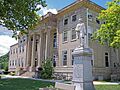
The Boyd County Courthouse in Catlettsburg, with a statue of John Milton Elliott
|
|
| Motto(s):
Unity and Progress
|
|

Location within the U.S. state of Kentucky
|
|
 Kentucky's location within the U.S. |
|
| Country | |
| State | |
| Founded | 1860 |
| Named for | Linn Boyd |
| Seat | Catlettsburg |
| Largest city | Ashland |
| Area | |
| • Total | 162 sq mi (420 km2) |
| • Land | 160 sq mi (400 km2) |
| • Water | 2.2 sq mi (6 km2) 1.3%% |
| Population
(2020)
|
|
| • Total | 48,261 |
| • Estimate
(2023)
|
47,826 |
| • Density | 297.9/sq mi (115.0/km2) |
| Time zone | UTC−5 (Eastern) |
| • Summer (DST) | UTC−4 (EDT) |
| Congressional districts | 4th, 5th |
Boyd County is a county located in the state of Kentucky. It's in the northeastern part of Kentucky. The county is close to the Ohio River and Big Sandy River. It is also part of the mountainous Appalachia region.
In 2020, about 48,261 people lived here. The main town, or county seat, is Catlettsburg. The biggest city in Boyd County is Ashland. Boyd County was created in 1860. It covers about 160 square miles (414 square kilometers). This area is part of the larger Huntington-Ashland metropolitan area.
Contents
History of Boyd County
Boyd County was the 107th county formed in Kentucky. It was created in 1860. Parts of Greenup, Carter, and Lawrence Counties were used to form it.
The county was named after Linn Boyd. He was a politician from Paducah. Linn Boyd served as a U.S. congressman. He was also the speaker of the United States House of Representatives. He passed away in 1859, shortly after being elected lieutenant governor of Kentucky.
Early Inhabitants and Settlers
Evidence shows that Native Americans lived in Boyd County a very long time ago. Archeologists found earthen mounds with human skeletons and items. In 1973, a special discovery was made. It was a serpent-shaped mound made of rocks. This mound is about 900 feet (274 meters) long. It was built around 2000 BC. It runs along a ridge near the Big Sandy River.
One of the first European settlers was Charles Smith from Virginia. He was a soldier in the French and Indian War. In 1774, he built a cabin near Chadwicks Creek. After he died, his land went to Alexander Catlett in 1797. The town of Catlettsburg is named after him.
The Poage family arrived in 1799. They started a settlement called Poage's Landing. This place later became the city of Ashland.
The first courthouse was built in 1861. A new one replaced it in 1912.
Industry and Growth
The Poage family built the first steam-powered iron furnace in 1832. This was the earliest industry in what is now Boyd County. Seven charcoal-fueled iron furnaces operated in the county.
In 1854, the Kentucky Iron, Coal and Manufacturing Company was formed. This company planned the town of Ashland. They bought a lot of land with coal, timber, and ore. They also helped bring the railroad to Ashland. The railroad was a big reason why Ashland grew to be the largest city in the county.
The Ashland furnace was sold to American Rolling Mill Company in 1921. This company became Armco Steel Corporation. In 1963, Armco built the Amanda furnace. It was one of the largest blast furnaces in the world. Today, this industry is known as AK Steel. It is still a major employer in the area.
Ashland Oil, Inc. was once the biggest company in Kentucky. It started in 1924 near Catlettsburg. The company was founded by Paul G. Blazer. They were famous for their Valvoline Oil products. Ashland Oil moved its headquarters in 1999. The original oil refinery in Catlettsburg is still working today. It is now owned by Marathon Petroleum Corporation.
Calgon Carbon built a large plant in 1961. This plant became the world's biggest producer of granular activated carbon. They make over 100 million pounds of this material every year.
Geography of Boyd County
Boyd County covers a total area of about 162 square miles (420 square kilometers). About 2.2 square miles (5.7 square kilometers) of this area is water.
Neighboring Counties
Boyd County shares borders with these counties:
- Greenup County (to the northwest)
- Lawrence County, Ohio (to the northeast)
- Wayne County, West Virginia (to the east)
- Lawrence County (to the south)
- Carter County (to the west)
Boyd County is unique because it borders two counties named Lawrence County. One is in Kentucky, and the other is in Ohio.
Infrastructure and Services

The Federal Bureau of Prisons runs the Federal Correctional Institution, Ashland. This prison is located in Summit. Summit is an unincorporated part of Boyd County. It is about 5 miles (8 kilometers) southwest of Ashland.
Kentucky State Police Post 14 is also in Summit. It serves Boyd, Carter, Greenup, and Lawrence Counties.
Education in Boyd County
Colleges and Universities
Ashland Community and Technical College is in Ashland. It is one of 16 two-year colleges in Kentucky. Morehead State University also has a campus in Ashland.
Public School Districts
Boyd County has several public school districts:
- Boyd County Public School District serves Catlettsburg and other county areas. It also serves parts of Ashland and Westwood.
- Ashland Independent School District serves most of Ashland.
- Fairview Independent School District serves most of Westwood. It also serves a part of Ashland.
Private Schools
- Holy Family School offers education from kindergarten to 12th grade.
- Rose Hill Christian also offers K-12 education.
Other Schools
- Ramey-Estep High School
Communities in Boyd County
Cities
- Ashland
- Catlettsburg (the county seat)
Census-designated places (CDPs)
Unincorporated Communities
Images for kids
-
The Boyd County Courthouse in Catlettsburg, with a statue of John Milton Elliott
See also
In Spanish: Condado de Boyd (Kentucky) para niños
