
Williamson, West Virginia facts for kids
Quick facts for kids
Williamson, West Virginia
|
|
|---|---|

Williamson, West Virginia; view looking down East 2nd Ave.
|
|

Location of Williamson in Mingo County, West Virginia
|
|
| Country | United States |
| State | West Virginia |
| County | Mingo |
| Area | |
| • Total | 3.27 sq mi (8.48 km2) |
| • Land | 3.27 sq mi (8.48 km2) |
| • Water | 0.00 sq mi (0.00 km2) |
| Elevation | 653 ft (199 m) |
| Population
(2020)
|
|
| • Total | 3,042 |
| • Density | 817.10/sq mi (315.52/km2) |
| Time zone | UTC-5 (Eastern (EST)) |
| • Summer (DST) | UTC-4 (EDT) |
| ZIP code |
25661
|
| Area code(s) | 304 |
| FIPS code | 54-87508 |
| GNIS feature ID | 1549185 |
Williamson is a city in West Virginia, a state in the United States. It is the main city, or county seat, of Mingo County. The city is located right next to the Tug Fork River. In 2020, about 3,042 people lived there.
Williamson is the biggest city in Mingo County. It is also home to Southern West Virginia Community and Technical College. The Tug Fork River acts as a border, separating Williamson from South Williamson, Kentucky in the nearby state of Kentucky.
A large rail yard was built in Williamson by the old Norfolk and Western Railroad. This rail yard helped move coal from the many coal mines in the area. The city is protected by a big floodwall. This wall was finished in 1991 by the U.S. Army Corps of Engineers. It was built to protect the city from floods, like the big ones that happened in 1977 and 1984. The floodwall has special gates that can be closed to stop floodwaters. These gates have only been used twice, once in 2002 and again in 2003.
The city's economy mainly relies on coal mining, transportation, healthcare, and local shops.
Contents
History of Williamson
Williamson became an official city in 1892. Many historians believe the city was named after Wallace J. Williamson. He owned the land where the city now stands. He also made a lot of money from real estate in the area. Wallace J. Williamson started the city's first bank and its first hotel.
Some people think the city was named after Wallace's father, Benjamin F. Williamson. Benjamin F. Williamson owned most of the land in the region before he shared it with his sons.
Williamson grew very quickly once the railroad came to town. In 1900, only 688 people lived there. By 1920, the population jumped to 6,819. It reached 9,410 people by 1930.
Williamson's Geography
The city of Williamson covers about 3.26 square miles (8.48 square kilometers) of land. There is no water area within the city limits.
Climate in Williamson
Williamson has a climate with hot, humid summers. The winters are generally mild to cool. This type of weather is called a humid subtropical climate.
| Climate data for Williamson, West Virginia (1991–2020 normals, extremes 1993–present) | |||||||||||||
|---|---|---|---|---|---|---|---|---|---|---|---|---|---|
| Month | Jan | Feb | Mar | Apr | May | Jun | Jul | Aug | Sep | Oct | Nov | Dec | Year |
| Record high °F (°C) | 80 (27) |
85 (29) |
90 (32) |
95 (35) |
98 (37) |
104 (40) |
104 (40) |
103 (39) |
99 (37) |
93 (34) |
88 (31) |
80 (27) |
104 (40) |
| Mean daily maximum °F (°C) | 46.5 (8.1) |
50.7 (10.4) |
59.7 (15.4) |
71.7 (22.1) |
78.6 (25.9) |
85.3 (29.6) |
88.6 (31.4) |
87.6 (30.9) |
82.2 (27.9) |
71.5 (21.9) |
61.0 (16.1) |
50.2 (10.1) |
69.5 (20.8) |
| Daily mean °F (°C) | 36.1 (2.3) |
39.8 (4.3) |
47.1 (8.4) |
57.6 (14.2) |
66.3 (19.1) |
73.9 (23.3) |
77.5 (25.3) |
76.6 (24.8) |
70.6 (21.4) |
59.1 (15.1) |
47.9 (8.8) |
40.2 (4.6) |
57.7 (14.3) |
| Mean daily minimum °F (°C) | 25.8 (−3.4) |
29.0 (−1.7) |
34.5 (1.4) |
43.5 (6.4) |
53.9 (12.2) |
62.5 (16.9) |
66.5 (19.2) |
65.6 (18.7) |
59.0 (15.0) |
46.6 (8.1) |
34.9 (1.6) |
30.1 (−1.1) |
46.0 (7.8) |
| Record low °F (°C) | −16 (−27) |
−13 (−25) |
6 (−14) |
25 (−4) |
34 (1) |
44 (7) |
45 (7) |
40 (4) |
40 (4) |
27 (−3) |
14 (−10) |
1 (−17) |
−16 (−27) |
| Average precipitation inches (mm) | 3.37 (86) |
3.37 (86) |
4.68 (119) |
4.02 (102) |
4.34 (110) |
5.38 (137) |
5.84 (148) |
3.90 (99) |
3.13 (80) |
3.16 (80) |
2.99 (76) |
4.12 (105) |
48.30 (1,227) |
| Average snowfall inches (cm) | 4.4 (11) |
3.0 (7.6) |
3.1 (7.9) |
0.1 (0.25) |
0.0 (0.0) |
0.0 (0.0) |
0.0 (0.0) |
0.0 (0.0) |
0.0 (0.0) |
0.0 (0.0) |
0.1 (0.25) |
2.4 (6.1) |
13.1 (33) |
| Average precipitation days (≥ 0.01 in) | 12.7 | 11.1 | 13.2 | 12.0 | 13.4 | 12.6 | 12.1 | 9.6 | 8.8 | 9.6 | 10.6 | 12.2 | 137.9 |
| Average snowy days (≥ 0.1 in) | 2.4 | 2.3 | 1.3 | 0.1 | 0.0 | 0.0 | 0.0 | 0.0 | 0.0 | 0.0 | 0.1 | 1.1 | 7.3 |
| Source: NOAA | |||||||||||||
Population of Williamson
| Historical population | |||
|---|---|---|---|
| Census | Pop. | %± | |
| 1900 | 688 | — | |
| 1910 | 3,561 | 417.6% | |
| 1920 | 6,819 | 91.5% | |
| 1930 | 9,410 | 38.0% | |
| 1940 | 8,366 | −11.1% | |
| 1950 | 8,624 | 3.1% | |
| 1960 | 6,746 | −21.8% | |
| 1970 | 5,831 | −13.6% | |
| 1980 | 5,219 | −10.5% | |
| 1990 | 4,154 | −20.4% | |
| 2000 | 3,414 | −17.8% | |
| 2010 | 3,191 | −6.5% | |
| 2020 | 3,042 | −4.7% | |
| U.S. Decennial Census | |||
The population of Williamson has changed over the years. It grew a lot in the early 1900s. In 2010, there were 3,191 people living in the city. About 87.3% of the people were White, and 9.4% were African American.
There were 1,524 households in 2010. About 22% of these households had children under 18 living with them. The average age of people in the city was 47.1 years old.
Arts and Culture in Williamson
The Coal House
The Coal House is a unique building in Williamson. Its walls are made from 65 tons of bituminous coal. This coal came from the nearby Winifrede Seam. The Coal House was built in 1933. It is now the main office for the Tug Valley Chamber of Commerce. The building is listed on the National Register of Historic Places. In 2010, a fire damaged the inside of the Coal House. However, it has since been fixed and looks like it did before, keeping its historical charm.
Williamson Field House
The Williamson Field House is a large building that can hold 6,000 people. It used to be the home court for the Williamson High School boys' basketball team.
Hatfield–McCoy Trails and Marathon
The Hatfield–McCoy Trails are a popular network of trails for ATVs. These trails go through the mountains around Williamson. There are many places to start riding the trails near the city. One of these trails, the Buffalo Trail, has a connection point in Williamson on W 4th Ave.
Every June, Williamson hosts the Hatfield–McCoy Marathon. Up to 500 runners from all over the United States and other countries come to participate. The race starts in South Williamson, Kentucky, and finishes in downtown Williamson. It ends during the annual Hatfield–McCoy Reunion Festival.
Media in Williamson
- WXCC-FM (a radio station)
- The Williamson Daily News (a local newspaper)
Transportation in Williamson
Major Highways
 U.S. Route 52
 U.S. Route 119

Notable People from Williamson
- H. Truman Chafin: A state senator from West Virginia.
- Robert H. Foglesong: A general in the U.S. Air Force.
Images for kids
-
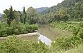
The Tug Fork River at Williamson.
-
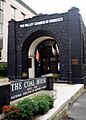
The Coal House in Williamson.
-
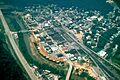
An aerial view of Williamson during the building of its floodwall, which was finished in 1991. The Tug Fork River is the border between West Virginia and Kentucky. The highway on the left (US-119) is in Kentucky.


See also
 In Spanish: Williamson (Virginia Occidental) para niños
