Calhoun County, West Virginia facts for kids
Quick facts for kids
Calhoun County
|
||
|---|---|---|

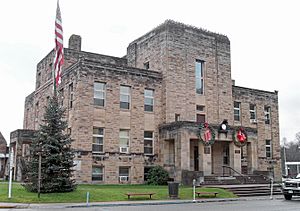
The Calhoun County Courthouse in Grantsville
|
||
|
||

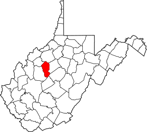
Location within the U.S. state of West Virginia
|
||
 West Virginia's location within the U.S. |
||
| Country | ||
| State | ||
| Founded | March 5, 1856 | |
| Named for | John C. Calhoun | |
| Seat | Grantsville | |
| Largest town | Grantsville | |
| Area | ||
| • Total | 281 sq mi (730 km2) | |
| • Land | 279 sq mi (720 km2) | |
| • Water | 1.4 sq mi (4 km2) 0.5%% | |
| Population
(2020)
|
||
| • Total | 6,229 | |
| • Estimate
(2021)
|
6,176 |
|
| • Density | 22.17/sq mi (8.559/km2) | |
| Time zone | UTC−5 (Eastern) | |
| • Summer (DST) | UTC−4 (EDT) | |
| Congressional district | 1st | |
Calhoun County is a special place in the state of West Virginia, USA. It's one of the many counties that make up the state.
In 2020, about 6,229 people lived here. This makes it the third-smallest county in West Virginia when you look at how many people live there. The main town, or 'county seat,' is Grantsville. Calhoun County was created in 1856. It was named after a famous politician from South Carolina called John C. Calhoun.
Contents
Exploring Calhoun County's Geography
Calhoun County covers a total area of about 281 square miles (728 square kilometers). Most of this area is land, about 279 square miles (723 square kilometers). A small part, about 1.4 square miles (3.6 square kilometers), is water.
Main Roads to Know
These are the most important roads that help people travel through Calhoun County:
Neighboring Counties
Calhoun County shares its borders with several other counties. These are like its neighbors:
- Ritchie County (to the north)
- Gilmer County (to the east)
- Braxton County (to the southeast)
- Clay County (to the south)
- Roane County (to the west)
- Wirt County (to the northwest)
People of Calhoun County
The number of people living in Calhoun County has changed over many years. Here's a look at the population from different times:
| Historical population | |||
|---|---|---|---|
| Census | Pop. | %± | |
| 1860 | 2,502 | — | |
| 1870 | 2,939 | 17.5% | |
| 1880 | 6,072 | 106.6% | |
| 1890 | 8,155 | 34.3% | |
| 1900 | 10,266 | 25.9% | |
| 1910 | 11,258 | 9.7% | |
| 1920 | 10,268 | −8.8% | |
| 1930 | 10,866 | 5.8% | |
| 1940 | 12,455 | 14.6% | |
| 1950 | 10,259 | −17.6% | |
| 1960 | 7,948 | −22.5% | |
| 1970 | 7,046 | −11.3% | |
| 1980 | 8,250 | 17.1% | |
| 1990 | 7,885 | −4.4% | |
| 2000 | 7,582 | −3.8% | |
| 2010 | 7,627 | 0.6% | |
| 2020 | 6,229 | −18.3% | |
| 2021 (est.) | 6,176 | −19.0% | |
| U.S. Decennial Census 1790–1960 1900–1990 1990–2000 2010–2020 |
|||
A Look at 2010
In 2010, there were 7,627 people living in Calhoun County. Most people were white (98.4%). A small number were American Indian, Black, Asian, or from other backgrounds. About 0.7% of the people were of Hispanic or Latino origin.
Families lived in 3,268 homes. About 26.5% of these homes had children under 18 living there. The average age of people in the county was about 45 years old.
Fun Things to See and Do
Calhoun County has some cool places to visit, especially if you love the outdoors!
Parks for Play
There are four public parks in Calhoun County:
- The Upper West Fork Park in Chloe, located on West Virginia Route 16.
- The West Fork Park in Arnoldsburg, found on U.S. Route 33.
- Mt. Zion Park, also on West Virginia Route 16.
- Calhoun County Park, which is another park on West Virginia Route 16.
Local Festivals
Calhoun County is known for its yearly events:
- The [West Virginia Wood Festival] is a popular event.
- The West Virginia Molasses Festival happens every September.
Other Interesting Spots
Calhoun County used to have one of the last drive-in movie theaters in the country, but it is now closed. The Calhoun County Library has one of the biggest collections of family history records in West Virginia. It also has a special "West Virginia Room" filled with books about the state and by authors from West Virginia.
Communities in Calhoun County
Calhoun County has one main town and many smaller communities.
The Main Town
- Grantsville (This is the county seat, meaning it's the center of the county's government.)
Local Districts
The county is divided into five areas for local government:
- District 1
- District 2
- District 3
- District 4
- District 5
Smaller Communities
Many smaller communities are spread throughout Calhoun County. These are places where people live but are not officially towns.
- Adam
- Altizer
- Annamoriah
- Arnoldsburg
- Ayers
- Beech
- Big Springs
- Bigbend
- Cabot Station
- Chloe
- Cremo
- Dodrill
- Douglas
- Euclid
- Five Forks
- Freed
- Hathaway
- Hattie
- Henrietta
- Hur
- Joker
- Leatherbark
- Liberty Hill
- Millstone
- Milo
- Minnora
- Mount Zion
- Mudfork
- Nicut
- Nobe
- Oka
- Orma
- Pink
- Pleasant Hill
- Purdy
- Rhoda
- Richardson
- Russet
- Sand Ridge
- Stinson
- Sycamore
- White Pine
See also
 In Spanish: Condado de Calhoun (Virginia Occidental) para niños
 | Selma Burke |
 | Pauline Powell Burns |
 | Frederick J. Brown |
 | Robert Blackburn |


