
Point Pleasant, West Virginia facts for kids
Quick facts for kids
Point Pleasant, West Virginia
|
||
|---|---|---|

Point Pleasant (foreground) at the confluence of the Kanawha and Ohio Rivers. Gallipolis, Ohio is in the background right while Henderson, West Virginia is on the left.
|
||
|
||

Location of Point Pleasant in Mason County, West Virginia.
|
||
| Country | United States | |
| State | West Virginia | |
| County | Mason | |
| Area | ||
| • Total | 3.09 sq mi (8.02 km2) | |
| • Land | 2.42 sq mi (6.26 km2) | |
| • Water | 0.68 sq mi (1.76 km2) | |
| Elevation | 568 ft (173 m) | |
| Population
(2020)
|
||
| • Total | 4,101 | |
| • Estimate
(2021)
|
4,031 | |
| • Density | 1,681.29/sq mi (649.10/km2) | |
| Time zone | UTC-5 (Eastern (EST)) | |
| • Summer (DST) | UTC-4 (EDT) | |
| ZIP code |
25550
|
|
| Area code(s) | 304 | |
| FIPS code | 54-64708 | |
| GNIS feature ID | 1555381 | |
| Website | www.ptpleasantwv.org | |


Point Pleasant is a city in West Virginia, United States. It is the main city of Mason County. The city is located where the Ohio and Kanawha Rivers meet. In 2020, about 4,101 people lived there. Point Pleasant is famous for the legend of the Mothman. This is a creature that people say they have seen in the area. It has become a big part of West Virginia's local stories.
Contents
History of Point Pleasant
Long ago, a village of the Shawnee people was in this area. It was called "Chinoudaista" or "Chinodahichetha." This was before 1749.
French Explorers in 1749

In 1749, a French explorer named Pierre Joseph Céloron de Blainville visited the area. He claimed the Ohio Valley for France. He buried a special lead plaque where the Ohio and Kanawha Rivers meet. This plaque said that France now owned the land.
The plaque's message was in French. It said that in 1749, during the time of King Louis XV, Céloron buried the plaque. He did this to show that France was taking back the land. This land included the Ohio River and all the rivers that flow into it.
Céloron's trip did not go as planned. The local Native American tribes wanted to stay friends with the British. British people living there also refused to leave. This disagreement led to fighting between the French and the British. This fighting became the French and Indian War in 1754. This war caused France to lose most of its lands in North America.
Even so, Céloron's trip was important for geography. It helped create the first map of the Ohio Valley. A Jesuit named Joseph Pierre de Bonnecamps made this map.
In 1770, George Washington visited this area. He said the land was full of buffalo and other wild animals. He also saw many birds like swans, geese, and ducks.
The Battle of Point Pleasant (1774)
A big battle happened here on October 10, 1774. It was called the Battle of Point Pleasant. Over a thousand Virginia soldiers, led by Colonel Andrew Lewis, fought against Native American warriors. These warriors were from the Shawnee and Mingo tribes. Their leader was Chief Cornstalk. The Virginia soldiers won the battle.
Some people in Point Pleasant call this the "First Battle of the American Revolutionary War." In 1908, the U.S. Senate agreed to build a monument there to remember it. However, most historians believe it was part of Lord Dunmore's War (1774). It was not part of the American Revolution (1775–1783).
-
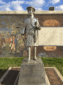
Statue of Lord Dunmore at Point Pleasant.
-
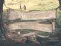
A mural with a quote about Dunmore's War.


Early Settlement of the Area
After the battle, Colonel Lewis set up a camp called "Camp Point Pleasant." The town that grew there took the same name. It is thought that white settlers may have moved to Point Pleasant as early as 1774. Around that time, a fort called Fort Blair was built. Before this, it was too dangerous to settle there because of fighting with Native Americans.
In 1776, a new fort was built where Fort Blair used to be. It was named Fort Randolph. This fort is known as the place where Chief Cornstalk was killed in 1777. The fort was attacked the next year but held strong. It was left empty in 1779.
George Washington's trip in 1770 was to check on land given to soldiers. These lands were given by Governor Dinwiddie in 1754. They were for officers and soldiers who fought in the French and Indian War. The land was divided among many people, including Andrew Lewis and George Washington himself.
Fort Randolph was rebuilt in 1785. This was because fighting started again between the United States and Native Americans. But the new fort was not used much and was soon left empty again. Point Pleasant officially became a town in 1794.
Point Pleasant in the 1800s
Mason County was created in 1804. Point Pleasant became the county seat, which means it was the main town for the county's government. A historian named Virgil A. Lewis said that Point Pleasant did not grow much for many years. There was no church for over 50 years. Some people believed the town was cursed because Chief Cornstalk was killed there.
In 1810, a visitor described Point Pleasant. They said it was nicely located where the Great Kanawha River meets the Ohio River. It had about 15 or 20 families. There was a courthouse and a jail. The town was not growing much because of problems with land ownership. However, it was a busy place for people traveling down the Ohio River from other parts of Virginia.
Point Pleasant officially became a town in 1833.
During the American Civil War, Mason County's representative voted against leaving the Union. Mason County sent over 1,000 men to fight for the Union army. Only 61 men from the county joined the Confederate Army. In March 1863, there was a small fight in Point Pleasant. Soldiers attacked the Mason County Courthouse, thinking weapons were stored there. Bullet holes were in the walls until a new courthouse was built in 1954.
Point Pleasant in the 1900s
Point Pleasant is sadly known for the collapse of the Silver Bridge in 1967. This accident killed 46 people.
On October 10, 1974, Point Pleasant celebrated the 200th anniversary of the Battle of Point Pleasant. A copy of Fort Randolph was built in 1973-74 for the celebration. The original fort was where the town now stands. So, the new fort was built about a mile away at Krodel Park.
Historic Places in Point Pleasant
Several places in Point Pleasant are on the National Register of Historic Places. These include the Eastham House, the Lewis-Capehart-Roseberry House, and the Point Pleasant Battleground. The main part of the city and nearby homes are also part of the Point Pleasant Historic District.
Geography and Climate
Point Pleasant covers about 3.10 square miles (8.02 square kilometers). About 2.40 square miles (6.26 square kilometers) is land, and 0.70 square miles (1.76 square kilometers) is water.
The city is home to Tu-Endie-Wei State Park and Krodel Park.
What is the Climate Like?
Point Pleasant has a humid subtropical climate. This means it has warm, humid summers and mild winters. Rain is spread out evenly throughout the year.
| Climate data for Point Pleasant, West Virginia | |||||||||||||
|---|---|---|---|---|---|---|---|---|---|---|---|---|---|
| Month | Jan | Feb | Mar | Apr | May | Jun | Jul | Aug | Sep | Oct | Nov | Dec | Year |
| Mean daily maximum °F (°C) | 45 (7) |
46 (8) |
58 (14) |
69 (21) |
78 (26) |
86 (30) |
89 (32) |
88 (31) |
83 (28) |
71 (22) |
57 (14) |
46 (8) |
68 (20) |
| Mean daily minimum °F (°C) | 25 (−4) |
25 (−4) |
33 (1) |
42 (6) |
51 (11) |
60 (16) |
64 (18) |
63 (17) |
56 (13) |
44 (7) |
34 (1) |
27 (−3) |
44 (7) |
| Average precipitation inches (mm) | 3.7 (94) |
3.2 (81) |
4.1 (100) |
3.5 (89) |
4 (100) |
4.3 (110) |
4.5 (110) |
3.6 (91) |
2.5 (64) |
2.5 (64) |
3 (76) |
3.4 (86) |
42.4 (1,080) |
| Source: Weatherbase | |||||||||||||
Population of Point Pleasant
| Historical population | |||
|---|---|---|---|
| Census | Pop. | %± | |
| 1870 | 773 | — | |
| 1880 | 1,036 | 34.0% | |
| 1890 | 1,853 | 78.9% | |
| 1900 | 1,934 | 4.4% | |
| 1910 | 2,045 | 5.7% | |
| 1920 | 3,059 | 49.6% | |
| 1930 | 3,301 | 7.9% | |
| 1940 | 3,538 | 7.2% | |
| 1950 | 4,596 | 29.9% | |
| 1960 | 5,785 | 25.9% | |
| 1970 | 6,122 | 5.8% | |
| 1980 | 5,682 | −7.2% | |
| 1990 | 4,996 | −12.1% | |
| 2000 | 4,637 | −7.2% | |
| 2010 | 4,350 | −6.2% | |
| 2020 | 4,101 | −5.7% | |
| 2021 (est.) | 4,031 | −7.3% | |
| U.S. Decennial Census | |||
What Was the Population in 2010?
In 2010, there were 4,350 people living in Point Pleasant. There were 2,014 households. Most people (95.9%) were White. About 1.3% were African American.
About 25.7% of households had children under 18. The average age in the city was 44 years old. About 21.5% of residents were under 18. More women lived in the city (55.1%) than men (44.9%).
Folklore and Legends
What is the Mothman Legend?
.jpg)
Many people who are interested in paranormal stories visit Point Pleasant. They come to look for the Mothman. This creature is said to warn people about bad things that are about to happen. It supposedly lives near an old TNT factory from World War II.
A book called The Mothman Prophecies was written about the creature in 1975. A movie based on the book came out in 2002. Another movie about the legend was also released later.
Point Pleasant has a Mothman Museum. Every year, the town holds a Mothman Festival. This festival includes tours, shows, movies, and music. It celebrates the Mothman, which is one of the city's biggest tourist attractions. There is also a 12-foot-tall metal statue of the creature in Point Pleasant.
Famous People from Point Pleasant
- Mark Twain's grandparents, Samuel B. Clemens and Pamela, lived in Point Pleasant early on.
- John McCausland was a Confederate General. He lived his last years near Point Pleasant and is buried nearby.
- Karl Probst was born in Point Pleasant. He was an engineer who designed the Jeep in 1940.
- The Shawnee Chief Cornstalk was held prisoner and later killed at Fort Randolph in 1777.
- Lee Anna Starr (1853–1937) was a Methodist church leader and fought for women's right to vote. She was born in Point Pleasant.
- Ray Stevens was a professional wrestler. He was added to the WWE Hall of Fame in 2021.
Images for kids
-
Statue of Lord Dunmore at Point Pleasant.
-
A mural with a quote about Dunmore's War.
See also
 In Spanish: Point Pleasant (Virginia Occidental) para niños
