
Henderson, West Virginia facts for kids
Quick facts for kids
Henderson, West Virginia
|
|
|---|---|
|
Unincorporated Town
|
|

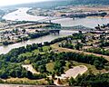
Henderson (left) at the confluence of the Kanawha and Ohio Rivers
|
|

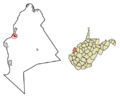
Location of Henderson in Mason County, West Virginia.
|
|
| Country | United States |
| State | West Virginia |
| County | Mason |
| Incorporated (town) | 1893 |
| Dissolved | 2022 |
| Area | |
| • Total | 0.46 sq mi (1.21 km2) |
| • Land | 0.42 sq mi (1.08 km2) |
| • Water | 0.05 sq mi (0.12 km2) |
| Elevation | 564 ft (172 m) |
| Population
(2020)
|
|
| • Total | 231 |
| • Estimate
(2021)
|
228 |
| • Density | 619.62/sq mi (239.00/km2) |
| Time zone | UTC-5 (Eastern (EST)) |
| • Summer (DST) | UTC-4 (EDT) |
| ZIP code |
25106
|
| Area code(s) | 304 |
| FIPS code | 54-36436 |
| GNIS feature ID | 1554681 |
Henderson is a small community in Mason County, West Virginia. It used to be an official town but is now an unincorporated community. This means it no longer has its own local government.
Henderson is located where two big rivers meet: the Ohio and the Kanawha. In 2020, about 231 people lived there. The town was officially created in 1893. It was named after Samuel Bruce Henderson, who owned the land at that time. Henderson stopped being an official town in August 2022.
Contents
History of Henderson
A special place called the General John McCausland Memorial Farm is located near Henderson. This farm is important because it is listed on the National Register of Historic Places. It was added to the list in 2003.
Geography and Location
Henderson is found at specific coordinates: 38.833035 degrees North and -82.137216 degrees West. These numbers help pinpoint its exact spot on a map.
The community covers a total area of about 0.47 square miles (1.21 square kilometers). Most of this area, about 0.42 square miles (1.08 square kilometers), is land. The rest, about 0.05 square miles (0.12 square kilometers), is water.
What is the Climate Like?
The weather in Henderson is usually warm. It gets rain fairly often throughout the year. According to a system that classifies climates, Henderson has a Humid subtropical climate. This type of climate is often called "Cfa" on climate maps. It means the area has hot, humid summers and mild winters.
| Climate data for Henderson, West Virginia | |||||||||||||
|---|---|---|---|---|---|---|---|---|---|---|---|---|---|
| Month | Jan | Feb | Mar | Apr | May | Jun | Jul | Aug | Sep | Oct | Nov | Dec | Year |
| Mean daily maximum °C (°F) | 6 (43) |
8 (47) |
14 (57) |
20 (68) |
25 (77) |
29 (85) |
31 (88) |
31 (87) |
27 (81) |
21 (70) |
14 (57) |
8 (46) |
19 (67) |
| Mean daily minimum °C (°F) | −5 (23) |
−4 (25) |
0 (32) |
5 (41) |
11 (51) |
16 (60) |
18 (64) |
17 (62) |
13 (55) |
6 (43) |
1 (34) |
−3 (26) |
6 (43) |
| Average precipitation mm (inches) | 79 (3.1) |
76 (3) |
99 (3.9) |
89 (3.5) |
100 (4.1) |
94 (3.7) |
110 (4.3) |
97 (3.8) |
79 (3.1) |
64 (2.5) |
74 (2.9) |
79 (3.1) |
1,040 (40.8) |
| Source: Weatherbase | |||||||||||||
Population Changes Over Time
The number of people living in Henderson has changed quite a bit over the years. Here's a look at the population from 1900 to 2020:
| Historical population | |||
|---|---|---|---|
| Census | Pop. | %± | |
| 1900 | 304 | — | |
| 1910 | 286 | −5.9% | |
| 1920 | 320 | 11.9% | |
| 1930 | 330 | 3.1% | |
| 1940 | 398 | 20.6% | |
| 1950 | 483 | 21.4% | |
| 1960 | 601 | 24.4% | |
| 1970 | 496 | −17.5% | |
| 1980 | 604 | 21.8% | |
| 1990 | 549 | −9.1% | |
| 2000 | 325 | −40.8% | |
| 2010 | 271 | −16.6% | |
| 2020 | 231 | −14.8% | |
| 2021 (est.) | 228 | −15.9% | |
| U.S. Decennial Census | |||
Who Lives in Henderson? (2010 Census)
In 2010, there were 271 people living in Henderson. These people lived in 114 different homes, and 72 of these were families.
Most of the people in Henderson were White (about 94.8%). A smaller number were African American (1.5%), Native American (1.1%), or Asian (1.8%). About 0.7% of the people were from two or more racial backgrounds. Less than 1% of the population was Hispanic or Latino.
About 31.6% of the homes had children under 18 living there. Many homes (38.6%) were married couples living together. Some homes had a female head of household without a husband (18.4%), or a male head of household without a wife (6.1%). About 33.3% of all homes had only one person living in them. About 8.8% of homes had someone 65 years or older living alone.
The average age of people in Henderson was 38.4 years old. About 24.7% of residents were under 18. About 14.8% were 65 years or older. The community had slightly more females (53.5%) than males (46.5%).
Images for kids
-
Henderson (left) at the confluence of the Kanawha and Ohio Rivers
-
Location of Henderson in Mason County, West Virginia.
See also
 In Spanish: Henderson (Virginia Occidental) para niños
