Winfield, West Virginia facts for kids
Quick facts for kids
Winfield, West Virginia
|
|
|---|---|

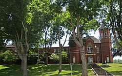
Putnam County Courthouse
|
|

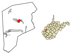
Location of Winfield in Putnam County, West Virginia.
|
|
| Country | United States |
| State | West Virginia |
| County | Putnam |
| Government | |
| • Type | Local Government |
| Area | |
| • Total | 2.43 sq mi (6.29 km2) |
| • Land | 2.41 sq mi (6.24 km2) |
| • Water | 0.02 sq mi (0.05 km2) |
| Elevation | 600 ft (183 m) |
| Population
(2020)
|
|
| • Total | 2,397 |
| • Estimate
(2021)
|
2,390 |
| • Density | 976.74/sq mi (377.15/km2) |
| Time zone | UTC-5 (Eastern (EST)) |
| • Summer (DST) | UTC-4 (EDT) |
| ZIP code |
25213
|
| Area code(s) | 304 |
| FIPS code | 54-87988 |
| GNIS feature ID | 1556008 |
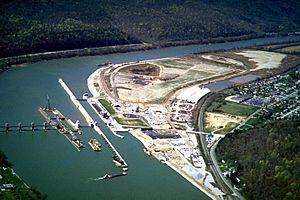
Winfield is a city in West Virginia, United States. It is the county seat of Putnam County, West Virginia, which means it's where the main government offices for the county are located. The city sits right along the Kanawha River.
In 2020, about 2,397 people lived in Winfield. It is also part of a larger area called the Huntington–Ashland metropolitan area.
Contents
History of Winfield
Winfield started on a piece of land about 400 acres big. This land belonged to a person named Charles Brown.
How Winfield Began
- In 1818, Charles Brown started a ferry service across the river. A ferry is like a boat that carries people and vehicles from one side of a river to the other.
- The very first meeting for the county government, called the county court, happened in Winfield. It took place at the home of Talleyrand P. Brown on May 22, 1848.
- The town officially became a city on February 21, 1868. It was named after Winfield Scott, who was a very important general in the United States Army during the Mexican–American War.
Historic Places in Winfield
Several important buildings and structures in Winfield are recognized for their history. In 2011, these places were added to the National Register of Historic Places:
- The James W. Hoge House
- The Putnam County Courthouse
- The Winfield Toll Bridge
Geography and Location
Winfield is located in West Virginia, right on the Kanawha River. Its exact location is 38°32′4″N 81°53′32″W / 38.53444°N 81.89222°W.
Land and Water Area
The United States Census Bureau says that Winfield covers a total area of about 2.43 square miles (6.29 square kilometers).
- Most of this area, about 2.41 square miles (6.24 square kilometers), is land.
- A small part, about 0.02 square miles (0.05 square kilometers), is water.

Population and People
Winfield has grown over the years. Here's a look at how its population has changed:
| Historical population | |||
|---|---|---|---|
| Census | Pop. | %± | |
| 1880 | 305 | — | |
| 1890 | 302 | −1.0% | |
| 1900 | 338 | 11.9% | |
| 1910 | 291 | −13.9% | |
| 1920 | 253 | −13.1% | |
| 1930 | 294 | 16.2% | |
| 1940 | 318 | 8.2% | |
| 1950 | 346 | 8.8% | |
| 1960 | 318 | −8.1% | |
| 1970 | 328 | 3.1% | |
| 1980 | 329 | 0.3% | |
| 1990 | 1,164 | 253.8% | |
| 2000 | 1,858 | 59.6% | |
| 2010 | 2,301 | 23.8% | |
| 2020 | 2,397 | 4.2% | |
| 2021 (est.) | 2,390 | 3.9% | |
| U.S. Decennial Census | |||
Who Lives in Winfield?
Based on the census from 2010, there were 2,301 people living in Winfield. These people made up 920 households and 660 families.
- Most people in Winfield are White (95.2%).
- There are also smaller groups of African American (1.2%), Native American (0.3%), and Asian (0.7%) residents.
- About 1.1% of the population identified as Hispanic or Latino.
Households and Families
- About 35.8% of households had children under 18 living with them.
- More than half (56.0%) were married couples living together.
- The average household had about 2.50 people, and the average family had about 2.96 people.
Age of Residents
The average age of people in Winfield was 40.2 years old.
- 26% of residents were under 18 years old.
- 11.3% were 65 years old or older.
- The population was almost evenly split between males (48.2%) and females (51.8%).
Education in Winfield
The Putnam County Schools system is in charge of the public schools in the Winfield area. Students in Winfield attend these schools:
- Winfield High School
- Winfield Middle School
- Winfield Elementary School
Notable People from Winfield
Some well-known people have come from Winfield:
- Michael Barber: A former player in the NFL (National Football League) and a member of the College Football Hall of Fame.
- Jim Lett: A former player in Major League Baseball.
See also
 In Spanish: Winfield (Virginia Occidental) para niños
 | Bessie Coleman |
 | Spann Watson |
 | Jill E. Brown |
 | Sherman W. White |

