Cairo, West Virginia facts for kids
Quick facts for kids
Cairo, West Virginia
|
|
|---|---|

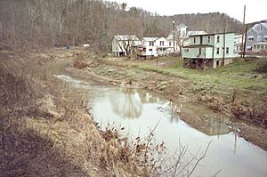
The North Fork of the Hughes River at Cairo
|
|

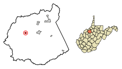
Location of Cairo in Ritchie County, West Virginia.
|
|
| Country | United States |
| State | West Virginia |
| County | Ritchie |
| Area | |
| • Total | 0.49 sq mi (1.26 km2) |
| • Land | 0.47 sq mi (1.22 km2) |
| • Water | 0.01 sq mi (0.04 km2) |
| Elevation | 653 ft (199 m) |
| Population
(2020)
|
|
| • Total | 174 |
| • Estimate
(2021)
|
172 |
| • Density | 538.14/sq mi (207.65/km2) |
| Time zone | UTC-5 (Eastern (EST)) |
| • Summer (DST) | UTC-4 (EDT) |
| ZIP code |
26337
|
| Area code(s) | 304 |
| FIPS code | 54-12124 |
| GNIS feature ID | 1536852 |
Cairo (pronounced KAIR-oh) is a small town in Ritchie County, West Virginia, USA. It's located right by the North Fork of the Hughes River. A popular path called the North Bend Rail Trail also runs through the town. In 2020, about 174 people lived there.
Contents
History of Cairo
The first settlers in Cairo were from Scotland. They were Presbyterians, a type of Christian faith. They named the town after the city of Cairo, Egypt. They chose this name because the area had plenty of water and good land for farming, just like the original Cairo.
Cairo officially became a town in 1895. The North Bend Rail Trail, which is a path for walking and biking, goes right through the town.
The old Bank of Cairo building is now the Cairo Town Hall. This building is important because it was added to the National Register of Historic Places in 1996. This means it's a special place that helps tell the story of the town.
Geography and Location
Cairo is located in West Virginia at specific coordinates: 39.208264 degrees North and 81.156600 degrees West.
The United States Census Bureau says the town covers a total area of about 0.48 square miles (1.26 square kilometers). Most of this area, about 0.47 square miles (1.22 square kilometers), is land. A small part, about 0.01 square miles (0.04 square kilometers), is water.
Climate in Cairo
The weather in Cairo has hot and humid summers. The winters are usually mild to cool. This type of weather is called a humid subtropical climate. On climate maps, you might see it labeled as "Cfa."
Population Information
| Historical population | |||
|---|---|---|---|
| Census | Pop. | %± | |
| 1880 | 75 | — | |
| 1900 | 653 | — | |
| 1910 | 668 | 2.3% | |
| 1920 | 662 | −0.9% | |
| 1930 | 607 | −8.3% | |
| 1940 | 532 | −12.4% | |
| 1950 | 500 | −6.0% | |
| 1960 | 418 | −16.4% | |
| 1970 | 412 | −1.4% | |
| 1980 | 428 | 3.9% | |
| 1990 | 290 | −32.2% | |
| 2000 | 263 | −9.3% | |
| 2010 | 281 | 6.8% | |
| 2020 | 174 | −38.1% | |
| 2021 (est.) | 172 | −38.8% | |
| U.S. Decennial Census | |||
The population of Cairo has changed over the years. In 1880, only 75 people lived there. The population grew quite a bit by 1900, reaching 653 people. Since then, the number of people living in Cairo has slowly decreased. In 2020, the population was 174.
2010 Census Details
According to the 2010 census, there were 281 people living in Cairo. These people lived in 118 households, and 71 of these were families.
- The town had about 598 people per square mile.
- All the people living in Cairo at that time were White.
- The average age of people in Cairo was about 40.6 years old.
- About 23.5% of the residents were under 18 years old.
- About 14.6% of the residents were 65 years or older.
- Slightly more than half of the residents (52.0%) were male, and 48.0% were female.
See also
 In Spanish: Cairo (Virginia Occidental) para niños
 | Audre Lorde |
 | John Berry Meachum |
 | Ferdinand Lee Barnett |

