
Crooked Tree, Ohio facts for kids
Quick facts for kids
Crooked Tree, Ohio
|
|
|---|---|

Mary Reed Memorial Methodist Church
|
|

Crooked Tree, Ohio
Location in Ohio

Crooked Tree, Ohio
Location in the United States
|
|
| Country | United States |
| State | Ohio |
| County | Noble |
| Elevation | 1,066 ft (325 m) |
| Time zone | UTC-5 (Eastern (EST)) |
| • Summer (DST) | UTC-4 (EDT) |
| Area code(s) | 740 |
| GNIS feature ID | 1061009 |
Crooked Tree is a small, quiet community in Noble County, Ohio, in the United States. It's called an unincorporated community because it doesn't have its own local government like a city or town. Instead, it's part of Jackson Township. You can find Crooked Tree about 2 miles (3.2 km) southwest of Dexter City, right along Ohio State Route 339.
What's the Story of Crooked Tree?
Crooked Tree has an interesting past! It wasn't always called Crooked Tree. When it was first planned out in 1854, its name was Jacksonville.
The community got its current name because there was a very crooked tree near where the town was first set up. Imagine a tree so twisty it became famous!
A post office opened in Crooked Tree in 1858. This was important for sending and receiving mail. The post office served the community for many years, closing down in 1904.
Images for kids
-
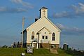
The Mary Reed Memorial Methodist Church in Crooked Tree.
