Zane's Trace facts for kids
{{Not to be confused with Zane Trace High School}}

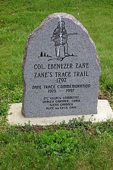
Zane's Trace was a very important road built a long time ago in the Northwest Territory of the United States. This area is now the state of Ohio. Colonel Ebenezer Zane led the building of this road. Many parts of the Trace followed old trails used by Native American tribes.
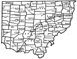
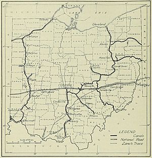
The road was built between 1796 and 1797. It stretched from Wheeling, Virginia (which is now Wheeling, West Virginia), all the way to Maysville, Kentucky. It went through the southeastern part of what would become Ohio. The Trace was over 230 miles (370 km) long. Several rivers interrupted the path, meaning travelers had to cross them.
Contents
Building Zane's Trace
After fighting in the American Revolutionary War, Colonel Zane went to Washington, D.C. in 1796. He asked the government for money to build a road. He wanted to help people move into the Northwest Territory. This road would also make travel to Kentucky much faster.
Colonel Zane would benefit from building the road. He owned land in Wheeling, where the road started. He also planned to buy land along the new route. The government agreed to help pay for the project in May 1796.
Who Helped Build It?
Colonel Zane had help overseeing the building of the Trace. His brother, Jonathan Zane, and his son-in-law, John McIntire, assisted him. A Native American guide named Tomepomehala also helped. Colonel Zane used existing Native American trails for some parts of the road.
For example, he used the Mingo Trail near Fairview, Ohio, and Zanesville, Ohio. He also used the Moxahala Trail between Zanesville and Chillicothe, Ohio. Chillicothe was the only town already there before the Trace was built. The Trace went through forests and hills. It was not easy for wagons to travel on it at first.
Making the Road Better
Ohio became a state in 1803. In 1804, the state government used a special tax to improve the entire Trace. Workers cleared out tree stumps and made the road wider.
Later, between 1825 and 1830, the part of Zane's Trace from Wheeling to Zanesville was rebuilt. This section became part of the new National Road.
Crossing Rivers and Streams
Travelers first crossed rivers and streams along the Trace by walking through shallow parts (called fords) or by using ferries. Colonel Zane ran a ferry across the Ohio River at Wheeling. A bridge was not built there until 1837.
Ferries also crossed Wills Creek near Cambridge, Ohio. William McCulloch and Henry Crooks ran a ferry across the Muskingum River at Zanesville. A bridge was built over the Muskingum River in 1813.
A bridge was built over the Hocking River near Lancaster, Ohio, as early as 1809. Benjamin Urmston ran the ferry across the Scioto River at Chillicothe. Ferries also crossed the Ohio River to Maysville, Kentucky. The town of Aberdeen, Ohio, was founded in 1816 on the Ohio side of the river. A bridge connecting Aberdeen and Maysville was not built until 1931.
Colonel Zane's Land
When Colonel Zane asked Congress for money, he also asked for something else. He wanted to buy special pieces of land where the Trace crossed three major rivers. These rivers were the Muskingum River, the Hocking River, and the Scioto River. Congress said yes to his request.
General Rufus Putnam, a government surveyor, measured these land areas. Colonel Zane bought all of them.
New Towns Along the Trace
Colonel Zane gave the land at the Muskingum River to his brother Jonathan Zane and his son-in-law, John McIntire, in 1800. McIntire had already planned a town there in 1799 called Westbourne. The postmaster changed the town's name to Zanesville in 1801.
Colonel Zane divided his land along the Hocking River into smaller pieces. He asked his sons, Noah Zane and John Zane, to sell these pieces. A town was planned here in 1800. It was named New Lancaster because a resident, Emmanuel Carpenter, Sr., wanted to honor his old home in Lancaster, Pennsylvania. The town was renamed Lancaster in 1805 to avoid confusion with another New Lancaster in Pennsylvania.
Colonel Zane's land on the Scioto River was not as easy to develop. The town of Chillicothe was already settled on the west side of the Scioto River. Also, land west of the Scioto River was saved for soldiers who fought in the Revolutionary War. Colonel Zane sold his land on the east side of the Scioto River in 1804.
|
 | Georgia Louise Harris Brown |
 | Julian Abele |
 | Norma Merrick Sklarek |
 | William Sidney Pittman |


