Maysville, Kentucky facts for kids
Quick facts for kids
Maysville, Kentucky
|
||
|---|---|---|
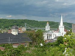
Maysville skyline showing the Mason County courthouse and the Simon Kenton Memorial Bridge over the Ohio River
|
||
|
||
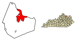
Location in Mason County, Kentucky
|
||
| Country | United States | |
| State | Kentucky | |
| County | Mason | |
| Area | ||
| • Total | 21.35 sq mi (55.30 km2) | |
| • Land | 18.97 sq mi (49.14 km2) | |
| • Water | 2.38 sq mi (6.16 km2) | |
| Elevation | 827 ft (252 m) | |
| Population
(2020)
|
||
| • Total | 8,873 | |
| • Estimate
(2022)
|
8,742 | |
| • Density | 467.64/sq mi (180.56/km2) | |
| Time zone | UTC−5 (Eastern (EST)) | |
| • Summer (DST) | UTC−4 (EDT) | |
| ZIP Codes |
41056, 41096
|
|
| Area code(s) | 606 | |
| FIPS code | 21-51024 | |
| GNIS feature ID | 2405043 | |
Maysville is a city in Mason County, Kentucky, United States. It is the main city of Mason County. In 2020, about 8,873 people lived there.
Maysville is located on the Ohio River, about 66 miles (106 km) northeast of Lexington. It is the most important city in the Maysville area. Two bridges cross the Ohio River from Maysville to Aberdeen, Ohio: the Simon Kenton Memorial Bridge (built in 1931) and the William H. Harsha Bridge (built in 2001).
This city is historically important for how Kentucky was settled. Famous frontiersmen like Simon Kenton and Daniel Boone helped start the city. Later, Maysville became a key port on the Ohio River. It was a major place for sending out goods like bourbon whiskey, hemp, and tobacco. Maysville was also known for making wrought iron items. These ironworks were sent downriver to decorate buildings in cities like Cincinnati, Ohio, and New Orleans, Louisiana.
Maysville was an important stop on the Underground Railroad. This was a secret network that helped people escape from slavery to freedom. The free state of Ohio was just across the river. The author Harriet Beecher Stowe visited the area in 1833. She saw a slave auction in front of the courthouse in Washington, which is now part of Maysville. She later wrote about this scene in her famous book, Uncle Tom's Cabin. This book was published in 1852 and helped many people understand the cruelty of slavery.
Contents
History of Maysville
How Maysville Began
Long ago, buffalo used to cross the Ohio River here. They made a wide path into Kentucky to find salt licks. For thousands of years, different groups of indigenous peoples lived in this area. They hunted buffalo and other animals. In the 1600s, the powerful Iroquois Confederacy from New York took control of the Ohio Valley as their hunting grounds.
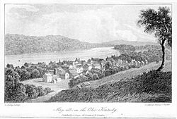
In the 1700s and early 1800s, European-American settlers traveled down the Ohio River. They found a natural harbor at Limestone Creek. The buffalo path was also a trail used by Native Americans for centuries. It led into the bluegrass region, all the way to Lexington, Kentucky.
Frontiersman Simon Kenton first settled here in 1775. But he left for a while to fight in the American Revolution. He came back in 1784 and built a blockhouse (a small fort) where Maysville is now. He also started Kenton's Station about 3 miles (5 km) inland. Kenton would meet new settlers at Limestone, the landing place, and guide them to his station.
In 1786, the village near Kenton's Station became the town of Washington. By this time, John May owned the land at Limestone. Daniel Boone also set up a trading post and a tavern there. In 1787, the small settlement was officially named Maysville. However, people still called it "Limestone" for many years.
Growing as a River Port
In 1788, Mason County was formed, and Washington became its county seat. Maysville was still mostly a place with warehouses and docks, and not many homes. After the Northwest Indian War ended in 1795, it was safer from Native American attacks. Maysville then began to grow.
Zane's Trace, a road from Wheeling, Virginia, to the Ohio River across from Maysville, was finished in 1797. This helped more people and goods cross the river by ferry. By 1807, Maysville was one of Kentucky's two main ports. It was still mostly a place where goods and people passed through, with only about sixty homes.
In 1811, the first steamboat came down the Ohio River from Pittsburgh, Pennsylvania. It passed Maysville on its way to New Orleans. With steamboats, Maysville's population and size grew very quickly.
The Maysville Road Story
The road southwest from Maysville followed the old buffalo and Native American trail to Lexington. It was called both the Maysville Road and the Limestone Road. Local counties kept the road in shape using local workers. The road was often rough and hard to use, especially in certain seasons.
In 1829, the Kentucky government approved a company to build a modern road. This road would go from Maysville through Washington, Paris, and Lexington. It would be a turnpike, meaning users would pay fees to help maintain it. The plan also allowed the U.S. government to buy shares in the company.
Henry Clay, a powerful politician from Kentucky, supported this road. He said it would be part of a longer road to New Orleans, Louisiana, and should get federal money.
In 1830, Congress passed a bill to let the federal government buy shares. But President Andrew Jackson stopped the bill. Jackson was a rival of Clay. He said the road only helped the local area, not the whole country. This event, called the Maysville Road veto, showed Jackson's ideas about how the federal government should spend money.
Congress tried to overturn Jackson's veto, but they failed. The turnpike was finished in 1835 with money from local groups and private investors. It was the first macadamized road (a type of paved road) in Kentucky. Today, this road is U.S. Route 68.
Becoming the County Seat
By the 1830s, Maysville had about 3,000 people. It was Kentucky's second most important business city, after Louisville. Washington, the county seat, became less important after a fire in 1825 and several serious cholera outbreaks.
There was a big debate about moving the county government from Washington to Maysville. It was a close vote, but the move passed in 1848. Maysville gave its city hall, built in 1846, to the county to use as a courthouse. Today, much of Washington is a historic district. It is listed on the National Register of Historic Places.
In 1850, the Maysville & Lexington Railroad started running. But it failed within ten years. Other companies kept the train connection going until 1921. Today, the old routes are owned by CSX Transportation.
Famous Landmarks in Maysville
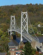
Simon Kenton Memorial Bridge
The Simon Kenton Memorial Bridge is a suspension bridge built in 1931. It crosses the Ohio River and connects Maysville with Aberdeen, Ohio. When it first opened, people had to pay a toll to cross. But in 1945, the tolls were removed. There were big celebrations, including a parade in downtown Maysville!
The main part of the bridge is 1,060 feet (323 meters) long. The whole bridge is 1,991 feet (607 meters) long. In 2001, the bridge was closed for repairs after the William H. Harsha Bridge was finished. It reopened in 2002 after a $5.8 million renovation. This work replaced the bridge's deck and gave it a fresh coat of gray paint.
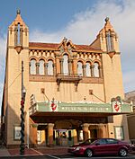
Russell Theatre
The Russell Theatre is on Third Street in Maysville. It was where the first movie of singer Rosemary Clooney, The Stars Are Singing, was shown in 1953. The Russell Theatre is an amazing "atmospheric theatre." It used to have a large rainbow that would light up before and after each movie.
The theater is now being restored. The goal is to bring the Russell back to life as a place for movies and films. They plan to show classic movies, documentaries, art films, and other movies you might not find at regular cinemas.
Maysville Murals: A Walk Through History
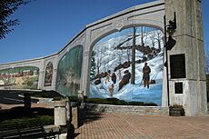
In 1998, artists started painting historical murals on the downtown floodwall. Over the next ten years, Robert Dafford and his team painted ten murals. These murals show different parts of Maysville's history.
- 17th Century River Valley Hunting Grounds: This mural shows Native Americans hunting bison on the buffalo trace.
- 18th Century Limestone Landing: This mural shows the first European-American settlers arriving at what was then called Limestone Landing.
- Marquis de Lafayette: This mural shows the visit of the Marquis de Lafayette in 1825. The city rolled out a red carpet for him!
- 1850s Sutton's Landing: This mural shows the Maysville riverfront before the American Civil War. It features classic steamboats on the Ohio River.
- Underground Railroad 1850s: This mural shows the Underground Railroad route in the area. You can see the John Rankin House in Ripley, Ohio, across the river.
- 20th Century Maysville Riverfront: This mural shows how the waterfront changed over time. Steamboats were replaced by trains and barge traffic.
- Market Street: This mural shows a main street in downtown Maysville in the early 1900s, with a bandstand in the middle.
- Germantown Fair: This fair has been held since 1854. The mural shows a wooden grandstand and livestock shows.
- Tobacco Barn: Tobacco was a big part of the local farming. This mural shows the tobacco plant from the field to harvest and storage.
- Rosemary Clooney: The last mural, painted in 2007, honors the life of singer Rosemary Clooney. It shows her friendship with Blanche Chambers, the premiere of her movie The Stars are Singing, and her singing career.
People and Population
| Historical population | |||
|---|---|---|---|
| Census | Pop. | %± | |
| 1800 | 137 | — | |
| 1810 | 335 | 144.5% | |
| 1830 | 2,040 | — | |
| 1840 | 2,741 | 34.4% | |
| 1850 | 3,840 | 40.1% | |
| 1860 | 3,499 | −8.9% | |
| 1870 | 4,705 | 34.5% | |
| 1880 | 5,220 | 10.9% | |
| 1890 | 5,358 | 2.6% | |
| 1900 | 6,423 | 19.9% | |
| 1910 | 6,141 | −4.4% | |
| 1920 | 6,107 | −0.6% | |
| 1930 | 6,557 | 7.4% | |
| 1940 | 6,572 | 0.2% | |
| 1950 | 8,632 | 31.3% | |
| 1960 | 8,484 | −1.7% | |
| 1970 | 7,411 | −12.6% | |
| 1980 | 7,983 | 7.7% | |
| 1990 | 7,169 | −10.2% | |
| 2000 | 8,993 | 25.4% | |
| 2010 | 9,011 | 0.2% | |
| 2020 | 8,873 | −1.5% | |
| 2022 (est.) | 8,742 | −3.0% | |
| U.S. Decennial Census | |||
In 2000, there were 7,323 people living in Maysville. There were 3,856 households and 2,406 families. The population density was about 451.6 people per square mile.
About 86% of the people were White, and 11.54% were African American. About 22.7% of the population was under 18 years old. The average age was 40 years. The median income for a household was $27,813.
Geography and Climate
Where is Maysville Located?
Maysville is on the Ohio River, where Limestone Creek flows into it. The city is built on a narrow flat area by the river and on the steep hills rising from it. This makes the city look like an Italian hill town. The city now includes the former town of Washington, which became part of Maysville in 1990.
Maysville covers about 21.35 square miles (55.30 km2). Most of this is land, with about 2.38 square miles (6.16 km2) being water. Maysville is at Ohio River mile marker 408.7. It is about 100 miles (160 km) downriver from Huntington, West Virginia, and 62 miles (100 km) upriver from Cincinnati, Ohio.
Maysville's Weather
Maysville has a mix of a humid subtropical and a hot summer continental climate. This means it has warm, humid summers and cool winters.
The city gets about 46 inches (117 cm) of rain or snow each year. The average yearly temperature is about 54.4°F (12.4°C). In January, the coolest lows average around 22.2°F (-5.4°C). In July, the highs average around 87°F (30.6°C).
| Climate data for Maysville, Kentucky (Maysville Wastewater Treatment Plant) (1991–2020 normals, extremes 1896–present) | |||||||||||||
|---|---|---|---|---|---|---|---|---|---|---|---|---|---|
| Month | Jan | Feb | Mar | Apr | May | Jun | Jul | Aug | Sep | Oct | Nov | Dec | Year |
| Record high °F (°C) | 80 (27) |
79 (26) |
89 (32) |
94 (34) |
100 (38) |
105 (41) |
108 (42) |
105 (41) |
103 (39) |
95 (35) |
84 (29) |
78 (26) |
108 (42) |
| Mean maximum °F (°C) | 64.0 (17.8) |
67.4 (19.7) |
75.0 (23.9) |
82.4 (28.0) |
87.4 (30.8) |
92.6 (33.7) |
94.6 (34.8) |
93.8 (34.3) |
92.0 (33.3) |
84.0 (28.9) |
73.8 (23.2) |
65.3 (18.5) |
96.0 (35.6) |
| Mean daily maximum °F (°C) | 41.2 (5.1) |
45.1 (7.3) |
54.6 (12.6) |
66.8 (19.3) |
75.4 (24.1) |
83.4 (28.6) |
86.8 (30.4) |
86.0 (30.0) |
80.7 (27.1) |
68.8 (20.4) |
55.9 (13.3) |
45.3 (7.4) |
65.8 (18.8) |
| Daily mean °F (°C) | 32.0 (0.0) |
34.8 (1.6) |
43.0 (6.1) |
53.7 (12.1) |
63.4 (17.4) |
72.0 (22.2) |
75.9 (24.4) |
74.8 (23.8) |
68.7 (20.4) |
56.9 (13.8) |
44.8 (7.1) |
36.5 (2.5) |
54.7 (12.6) |
| Mean daily minimum °F (°C) | 22.8 (−5.1) |
24.4 (−4.2) |
31.3 (−0.4) |
40.7 (4.8) |
51.4 (10.8) |
60.6 (15.9) |
65.1 (18.4) |
63.6 (17.6) |
56.7 (13.7) |
44.9 (7.2) |
33.8 (1.0) |
27.7 (−2.4) |
43.6 (6.4) |
| Mean minimum °F (°C) | 4.3 (−15.4) |
8.0 (−13.3) |
17.9 (−7.8) |
26.2 (−3.2) |
38.0 (3.3) |
48.7 (9.3) |
56.0 (13.3) |
54.4 (12.4) |
43.9 (6.6) |
32.3 (0.2) |
20.6 (−6.3) |
12.9 (−10.6) |
1.0 (−17.2) |
| Record low °F (°C) | −25 (−32) |
−22 (−30) |
0 (−18) |
11 (−12) |
27 (−3) |
37 (3) |
46 (8) |
39 (4) |
29 (−2) |
15 (−9) |
−1 (−18) |
−20 (−29) |
−25 (−32) |
| Average precipitation inches (mm) | 3.64 (92) |
3.40 (86) |
4.74 (120) |
4.66 (118) |
5.05 (128) |
4.35 (110) |
5.04 (128) |
3.36 (85) |
3.52 (89) |
3.27 (83) |
3.19 (81) |
4.10 (104) |
48.32 (1,227) |
| Average precipitation days (≥ 0.01 in) | 12.4 | 10.6 | 12.3 | 12.9 | 14.0 | 11.5 | 9.8 | 8.4 | 8.0 | 8.8 | 10.5 | 12.1 | 131.3 |
| Source: NOAA | |||||||||||||
Education in Maysville
Mason County Schools runs the public schools in Maysville.
Here are some of the schools:
- Mason County High School
- Mason County Middle School
- Mason County Intermediate School
- Straub Elementary School
There is also a private school:
- Saint Patrick School
In 1990, the Maysville Independent School District joined the Mason County school district. Maysville also has a lending library, the Mason County Public Library.
Media and Entertainment
The Ledger Independent is the local newspaper in Maysville. It is published five days a week. WFTM-AM and WFTM-FM are the main local radio stations. The AM station plays CBS Sports Radio, and the FM station plays adult contemporary music.
The annual Rosemary Clooney Music Festival was started by the singer in 1999. It helps raise money to restore the Russell Theatre. Many famous performers have been at the festival, including Debby Boone, Rita Coolidge, Michael Feinstein, Roberta Flack, Alison Krauss, The Pointer Sisters, Michael Bolton, and Linda Ronstadt.
Getting Around Maysville
Train Travel
Amtrak, the national passenger train system, serves Maysville. The Cardinal train stops here three times a week.
Bus Service
Maysville City Transit offers bus service throughout the city. There is one main bus route that runs daily, every hour from 6:00 AM to 6:00 PM. The city has been running this bus system since 1960.
Major Highways
Several important highways serve Maysville:
- U.S. Route 68: This road connects downtown Maysville with Aberdeen, Ohio, by crossing the Simon Kenton Memorial Bridge.
- U.S. Route 62: This road passes just west of Maysville. It links Kentucky and Ohio using the William H. Harsha Bridge.
- US 62 and 68 also provide a direct route from Maysville to Lexington and the Bluegrass Region.
Other highways in Maysville include:
- Kentucky Route 8: This road follows the Ohio River west of Maysville towards the Cincinnati area.
- Kentucky Route 9
- Kentucky Route 10
Routes 9 and 10 run together along the south edge of Maysville. This road is called the AA Highway. The AA Highway connects the Kentucky suburbs of Cincinnati (about 50 miles west of Maysville) with Vanceburg, Ashland, and Interstate 64 near Grayson to the southeast.
- Kentucky Route 11: This north-south highway comes into Maysville from the south, from Flemingsburg and Mt. Sterling.
Maysville is one of the few towns where highways numbered 8, 9, 10, and 11 all meet!
Notable People from Maysville
Many interesting people have come from Maysville:
- Luther Atwood: A chemist in the oil industry.
- Ted Berry: The first African-American mayor of Cincinnati.
- Thornton Blackburn: A former slave whose court case in Canada helped establish that Canada would not return slaves to their masters. This made Canada a safe end point for the Underground Railroad.
- Nick Clooney: A journalist and TV host. He is Rosemary Clooney's brother and George Clooney's father.
- Rosemary Clooney: A very popular singer and actress.
- John J. Collins: A Roman Catholic bishop.
- John S. Darrough: A Civil War soldier who received the Medal of Honor.
- Alexander Doniphan: A general and lawyer known for saving the life of Joseph Smith, who founded the Latter Day Saint movement.
- Edward Gallenstein: A long-serving president of the National Wood Carvers Association.
- Alison Lundergan Grimes: A former Secretary of State of Kentucky.
- J. Fred Helf: A composer.
- Heather French Henry: Miss America 2000.
- Francis T. Hord: A former Indiana Attorney General.
- Oscar B. Hord: A former Indiana Attorney General.
- Albert Sidney Johnston: A Confederate general and a leading general in the Texas War of Independence.
- Chris Lofton: A professional and college basketball player.
- Jerry Lundergan: A member of the Kentucky House of Representatives and former chairman of the Kentucky Democratic Party.
- Ed McClanahan: A writer.
- George McCulloch: A congressman from Pennsylvania.
- Darius Miller: A professional basketball player and NCAA Div. 1 National Champion.
- William "Bull" Nelson: A U.S. Army general.
- Josephine R. Nichols: A lecturer and temperance reformer.
- Barbara Paul: A novelist.
- Elijah Phister: A congressman from Kentucky.
- Stanley Forman Reed: A U.S. Supreme Court justice.
- Nelson Stacy: A race car driver who was an ARCA Champion and won many NASCAR races.
- Mary Lee Tate: A painter and teacher.
- Dave Tomlin: A professional baseball player.
- William H. Wadsworth: A congressman from Kentucky.
- Walter Warder: An Illinois state legislator and lawyer.
- Augustus E. Willson: A former governor of Kentucky.
- Brigadier General Charles Young: A U.S. Army officer and the first African-American officer to become a colonel.
See also
 In Spanish: Maysville (Kentucky) para niños
 | Emma Amos |
 | Edward Mitchell Bannister |
 | Larry D. Alexander |
 | Ernie Barnes |


