Vincennes Trace facts for kids
The Vincennes Trace was a very old path that ran through parts of what are now Kentucky, Indiana, and Illinois in the United States. It was first made by millions of bison (also called buffalo) as they moved across the land.
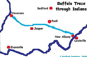
This path crossed the Ohio River near the Falls of the Ohio. From there, it went northwest to the Wabash River, close to a town now called Vincennes. Then it continued into Illinois. This buffalo trail was often 12 to 20 feet wide in some places. Native Americans knew and used it for a very long time. Later, European traders and American settlers also used it. It became an important land route for people traveling west into Indiana and Illinois. Many people think it was the most important path leading to the Illinois country.
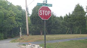
The Trace was known by several names, like Buffalo Trace, Louisville Trace, Clarksville Trace, and Old Indian Road. Over the years, it was improved. Parts of it were even paved and developed with roadsides. Today, U.S. Route 150 between Vincennes, Indiana, and Louisville, Kentucky, follows some of this old path. Sections of the improved Trace are now part of a special road called a National Scenic Byway in southern Indiana.
How the Trace Was Made
The Vincennes Trace was created by millions of bison. These animals were very common in the area, from the Great Lakes all the way down to Tennessee. The Trace was part of a much larger buffalo migration route. This route started in places like Big Bone Lick State Park in Kentucky. It went through areas south of modern-day Louisville. Then it crossed the Ohio River into Indiana. From there, it continued northwest to Vincennes. Finally, it crossed the Wabash River into Illinois.
Native Americans in the area knew this trail well. They had used it for hundreds of years. Later, European traders and white settlers also discovered it. They crossed the Ohio River at the Falls and followed the Trace overland. This path helped them travel to the western territories. It was seen as the most important early trail leading to the Illinois country.
In Indiana, the main path of the Trace split into smaller trails. These trails came together north of Jasper. This area had many large ponds or mud holes where buffalo would roll around. Because so many buffalo used the Trace, the path was very worn down. In some spots, it was 12 to 20 feet wide. Other trails also met near a big salt lick, likely close to today's French Lick, Indiana. The Trace crossed the White River at several points. These crossings were near towns like Petersburg and Portersville, Indiana. After a major crossing at the Wabash River, the Trace split again. Some trails went west across Illinois to the Mississippi River. Others went north to what would become Chicago. In Chicago, a part of the Trace is now called Vincennes Avenue. After improvements, some parts became State Street.
Early Settlements and Travel
The Trace across southern Indiana was very important for early settlements. Two main areas of early settlement in the Indiana Territory grew along it. These were Vincennes in the west and Clark's Grant in the south. In the early 1700s, French explorers set up trading posts in the Illinois Country. They traveled down the Mississippi River and into its smaller rivers. In 1732, François-Marie Bissot, Sieur de Vincennes started a trading post near where the Trace crossed the Wabash River. This post grew into the town of Vincennes.
After the American Revolutionary War, the U.S. government gave land to soldiers. This was payment for their service. Land was given in New York, Ohio, and Indiana. George Rogers Clark and his soldiers received land in Indiana for their military actions against the British. This area became known as Clark's Grant. George Rogers Clark himself used the Trace to return to the Louisville area after his military campaign.
During the Revolutionary War, the Trace became a very busy route. This also made it a target for Native American war parties. George Rogers Clark wrote about an early attack on traders in 1779. This happened after his militia took control of Vincennes. He led his forces against Native Americans in a battle near the White River. Richard "Dickie" Clark, the younger brother of General George Rogers Clark, disappeared while traveling the Trace in 1784. He had left Clarksville to go to Vincennes alone. His horse was found, but he was never seen again. People thought he might have been killed or drowned.
Improving the Trace
Many explorers, soldiers, and settlers wrote about using the Trace. In 1785 and 1786, explorer John Filson traveled by river to Vincennes. He then returned to the Falls of the Ohio using the Trace. His overland trip took nine days. General Josiah Harmar, a military commander, also kept a log when he marched his soldiers back from Vincennes in 1786. After the Treaty of Greenville in 1795, many settlers moved into the western territories. Many of them wrote journals about their journeys along the Trace.
In 1799, U.S. postmaster Joseph Habersham set up a mail route along the Trace. It went from Louisville through Vincennes to Kaskaskia, Illinois on the Mississippi River. This mail route started on March 22, 1800, and ran every four weeks. The next year, it was extended to Cahokia, Illinois. Both Kaskaskia and Cahokia were old French settlements.
In 1802, William Henry Harrison, who was the governor of the Indiana Territory, suggested improving the Trace. He wanted it to be a road good enough for wagons. He also wanted inns built every thirty to forty miles for travelers. By 1804, the Trace was so well known that Harrison used it as a boundary in a treaty with Native Americans. The Vincennes treaty of 1804 gave the U.S. government land in Indiana. This land was south of the Trace to the Ohio River, and it included the Trace itself. William Rector was hired to survey this land in 1805. His survey notes are an important record of the Buffalo Trace's exact route. These notes and maps showed 43 miles of the old Trace road in southern Indiana.
The Buffalo Trace was the main way to travel between the Louisville area and Vincennes. About two-thirds of settlers going from Louisville into Indiana used this path. Rangers were hired to protect travelers on the road. By 1812, they were doing this on horseback. During the War of 1812, Governor Harrison assigned 150 men to patrol the Trace. Their job was to protect the people and the road between Vincennes and Louisville.
After Indiana became a state in 1816, the Trace remained the main road across southern Indiana. The state government decided to pave a road from New Albany to Vincennes. This new road followed the Trace's route very closely. It was later extended to Paoli, Indiana. The state leased the road to a private company to avoid financial problems. This paved road was called the "New Albany-Paoli Turnpike." The first stagecoach service in Indiana started in 1820 along the Trace. This route went from New Albany to Vincennes. It served towns like Greenville, Galena, and Floyds Knobs in Floyd County, Indiana.
Over time, the Trace had many names. These included Lan-an-zo-ki-mi-wi (an Indian name meaning "bison trail" or "buffalo road"), the "Old Indian Road," the "Clarksville Trace," "Harrison's Road," the "Kentucky Road," the "Vincennes Trace," and the "Louisville Trace."
The Trace Today
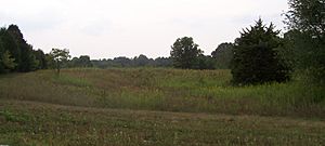
Today, U.S. Route 150 from Vincennes to New Albany follows the path of the old Trace. You can still see a large part of the original Trace south of French Lick in Orange County, Indiana. This section is along the Springs Valley Trail System. In 2009, a part of U.S. Route 150 and the Buffalo Trace was named part of the Indiana Historic Pathways. This is a National Scenic Byway that crosses southern Indiana. Driving U.S. Route 150 along the Buffalo Trace covers a distance of 112 miles (180 km).
Some parts of the Trace are now protected. These include sections in the Hoosier National Forest and a small area within Buffalo Trace Park. This park is maintained by Harrison County, Indiana. Many parts of the original Trace have been covered by towns and highways. However, old survey notes, maps, and other documents help archaeologists find more sections. They use modern tools like GIS (Geographic Information Systems) and GNSS (Global Navigation Satellite Systems) to help them.

 | Janet Taylor Pickett |
 | Synthia Saint James |
 | Howardena Pindell |
 | Faith Ringgold |


