St. Clairsville, Ohio facts for kids
Quick facts for kids
St. Clairsville, Ohio
|
|
|---|---|

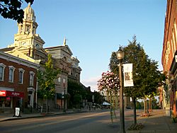
Downtown St. Clairsville
|
|
| Nickname(s):
Paradise On The Hilltop
|
|

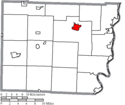
Location of St. Clairsville in Belmont County
|
|
| Country | United States |
| State | Ohio |
| County | Belmont |
| Area | |
| • Total | 2.44 sq mi (6.32 km2) |
| • Land | 2.42 sq mi (6.27 km2) |
| • Water | 0.02 sq mi (0.05 km2) |
| Elevation | 1,224 ft (373 m) |
| Population
(2020)
|
|
| • Total | 5,096 |
| • Density | 2,104.05/sq mi (812.24/km2) |
| Time zone | UTC-5 (Eastern (EST)) |
| • Summer (DST) | UTC-4 (EDT) |
| ZIP code |
43950
|
| FIPS code | 39-69526 |
| GNIS feature ID | 2396482 |
| Website | http://www.stclairsville.com/ |
St. Clairsville, also known as Saint Clairsville, is a city in Ohio, United States. It is the main city of Belmont County. In 2020, about 5,096 people lived there. The city is part of the larger Wheeling metropolitan area.
Contents
History of St. Clairsville
The area that is now St. Clairsville was first called Newellstown. It was started in the late 1790s by David Newell. The town's name soon changed to St. Clairsville. This was to honor Arthur St. Clair. He was a Major-General in the Revolutionary War. He also served as the Governor of the Northwest Territory.
By 1833, St. Clairsville was a busy place. It had a brick courthouse and a jail. There were five churches and many stores. The town also had several doctors and lawyers. In the 1960s, a TV show called "On the Road" with Charles Kuralt visited St. Clairsville.
Geography and Location
St. Clairsville covers about 2.44 square miles (6.32 square kilometers). Most of this area is land. Only a small part, about 0.02 square miles (0.05 square kilometers), is water.
The official seal of Belmont County has 13 stars. These stars show that Belmont County was the 13th area to become part of the US Northwest Territory.
Population and People
| Historical population | |||
|---|---|---|---|
| Census | Pop. | %± | |
| 1810 | 431 | — | |
| 1820 | 641 | 48.7% | |
| 1830 | 789 | 23.1% | |
| 1840 | 829 | 5.1% | |
| 1850 | 1,025 | 23.6% | |
| 1860 | 999 | −2.5% | |
| 1870 | 1,056 | 5.7% | |
| 1880 | 1,128 | 6.8% | |
| 1890 | 1,191 | 5.6% | |
| 1900 | 1,210 | 1.6% | |
| 1910 | 1,393 | 15.1% | |
| 1920 | 1,561 | 12.1% | |
| 1930 | 2,440 | 56.3% | |
| 1940 | 2,797 | 14.6% | |
| 1950 | 3,040 | 8.7% | |
| 1960 | 3,865 | 27.1% | |
| 1970 | 4,754 | 23.0% | |
| 1980 | 5,452 | 14.7% | |
| 1990 | 5,162 | −5.3% | |
| 2000 | 5,057 | −2.0% | |
| 2010 | 5,184 | 2.5% | |
| 2020 | 5,096 | −1.7% | |
| 2021 (est.) | 5,048 | −2.6% | |
| Sources: | |||
St. Clairsville Population in 2010
In 2010, there were 5,184 people living in St. Clairsville. These people lived in 2,386 households. About 1,407 of these were families. The city had about 2,142 people per square mile.
Most of the people in the city were White (94.7%). About 2.8% were African American. About 1.0% were Asian. A small number were Native American or from other backgrounds. About 0.7% of the people were Hispanic or Latino.
About 22.2% of households had children under 18. Many households (46.4%) were married couples. About 37.3% of households were individuals living alone. About 20.4% of these were people aged 65 or older. The average age in the city was 49.7 years.
Attractions and Economy
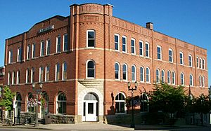
The city owns the Clarendon Hotel. This old hotel was built in 1890. It is located along the National Road, which is a special scenic road. The city plans to fix up the hotel.
Murray Energy, a large energy company, has its main office in St. Clairsville.
Arts and Culture
The main place for shopping is the Ohio Valley Mall. This mall first opened in 1978.
St. Clairsville also has a popular bicycle path. It is about 2.5 miles (4 kilometers) long. The path goes from the Saginaw Mine entrance to the Junior Sports complex. Along the path, you can find a gazebo, nature trails, and two tunnels. There is also an old railroad bridge. This bike path is special because it is the only one in Ohio with a rail tunnel.
Education in St. Clairsville
St. Clairsville has its own school system. Students from pre-kindergarten to twelfth grade attend these schools. They go to St. Clairsville High School, Middle School, and Elementary School. The school mascot is the Red Devil. This name comes from local coal miners. They would get covered in red dust from a mine area called Hell's Kitchen.
There is also St. Mary's School in the city. It teaches students from pre-kindergarten to eighth grade. Their mascot is the Knights. St. Mary's School is a Roman Catholic school.
For higher education, St. Clairsville has Belmont College. It also has the Ohio University Eastern Campus.
Transportation
St. Clairsville is located along two major roads. These are Interstate 70 and U.S. Route 40. Route 40 runs close to the historic National Road. The town is also served by Ohio State Route 9. The western end of Interstate 470 is also nearby.
St. Clairsville has a private airport called Alderman Airport. For general aviation, the closest airport is Wheeling Ohio County Airport. The nearest large airport for commercial flights is Pittsburgh International Airport.
Famous People from St. Clairsville
Many notable people have come from St. Clairsville:
- Sylvester Antolak – A brave soldier who received the Medal of Honor.
- Alice A. W. Cadwallader – A person known for helping others and supporting temperance.
- James E. Carnes – A former Ohio State Senator.
- Thomas Eckert – Served as the Assistant Secretary of War from 1865 to 1869.
- John Jacob Lentz – The founder of the American Insurance Union and a former member of Congress.
- Benjamin Lundy – A Quaker leader who worked against slavery.
- Edmund A. Sargus, Jr. – A U.S. Federal Judge.
- Jeremy Sowers – A starting pitcher for the Cleveland Indians baseball team.
- Tim Spencer – An Ohio State running back and coach. He also played for the San Diego Chargers.
- Charlie Wilson – A former U.S. Representative from Ohio's 6th Congressional District.
See also
 In Spanish: St. Clairsville (Ohio) para niños
 | Lonnie Johnson |
 | Granville Woods |
 | Lewis Howard Latimer |
 | James West |


