
Yorkville, Ohio facts for kids
Quick facts for kids
Yorkville, Ohio
|
|
|---|---|
|
Village
|
|

Business district
|
|

Location of Yorkville, Ohio
|
|

Location of Yorkville in Belmont County
|
|
| Country | United States |
| State | Ohio |
| Counties | Belmont, Jefferson |
| Townships | Warren, Pease |
| Area | |
| • Total | 0.60 sq mi (1.55 km2) |
| • Land | 0.59 sq mi (1.53 km2) |
| • Water | 0.01 sq mi (0.02 km2) |
| Elevation | 676 ft (206 m) |
| Population
(2020)
|
|
| • Total | 968 |
| • Density | 1,635.14/sq mi (630.90/km2) |
| Time zone | UTC-5 (Eastern (EST)) |
| • Summer (DST) | UTC-4 (EDT) |
| ZIP code |
43971
|
| Area code(s) | 740 |
| FIPS code | 39-87178 |
| GNIS feature ID | 2399754 |
Yorkville is a small town in Ohio, a state in the United States. It's special because it's located in two different counties: Belmont County and Jefferson County. In 2020, about 968 people lived there. Yorkville is also part of two larger city areas, called Metropolitan Statistical Areas. One part is near Wheeling, and the other is near Weirton and Steubenville.
Contents
History of Yorkville
A post office was opened in Yorkville in 1867. This means people could send and receive mail there. Yorkville started as a mining community. This means many people who lived there worked in mines, digging for things like coal.
Geography of Yorkville
Yorkville is located right next to the Ohio River. This is a very large and important river in the United States.
The United States Census Bureau is a group that collects information about places. They say that Yorkville is about 0.60 square miles (1.55 square kilometers) in total area. Almost all of this area is land.
Population and People in Yorkville
This section shows how the number of people living in Yorkville has changed over many years.
| Historical population | |||
|---|---|---|---|
| Census | Pop. | %± | |
| 1920 | 1,754 | — | |
| 1930 | 1,963 | 11.9% | |
| 1940 | 1,961 | −0.1% | |
| 1950 | 1,854 | −5.5% | |
| 1960 | 1,801 | −2.9% | |
| 1970 | 1,656 | −8.1% | |
| 1980 | 1,447 | −12.6% | |
| 1990 | 1,246 | −13.9% | |
| 2000 | 1,230 | −1.3% | |
| 2010 | 1,079 | −12.3% | |
| 2020 | 968 | −10.3% | |
| U.S. Decennial Census | |||
Yorkville's Population in 2010
In 2010, there were 1,079 people living in Yorkville. These people lived in 498 different homes. About 291 of these homes were families.
Most of the people in Yorkville were White (98.1%). A smaller number were African American (1.4%). Very few people were Native American (0.1%) or from two or more different backgrounds (0.4%).
The average age of people in Yorkville was 46.4 years old.
- About 17% of the people were under 18 years old.
- About 8.6% were between 18 and 24 years old.
- About 22.6% were between 25 and 44 years old.
- About 29.8% were between 45 and 64 years old.
- About 22.1% were 65 years old or older.
There were slightly more females (52.5%) than males (47.5%) in the village.
Education in Yorkville
Children in Yorkville go to public schools that are part of the Buckeye Local School District. This school district helps make sure students get a good education.
Climate and Weather in Yorkville
The weather in Yorkville usually has warm temperatures and rain spread out throughout the year. According to a system called the Köppen Climate Classification, Yorkville has a "Humid subtropical climate." This means it often has warm, humid summers and mild winters.
| Climate data for Yorkville, Ohio | |||||||||||||
|---|---|---|---|---|---|---|---|---|---|---|---|---|---|
| Month | Jan | Feb | Mar | Apr | May | Jun | Jul | Aug | Sep | Oct | Nov | Dec | Year |
| Mean daily maximum °C (°F) | 3 (37) |
4 (40) |
9 (49) |
17 (62) |
22 (71) |
26 (79) |
28 (83) |
28 (82) |
24 (76) |
18 (64) |
12 (53) |
5 (41) |
16 (61) |
| Daily mean °C (°F) | −1 (30) |
0 (32) |
4 (40) |
11 (51) |
16 (60) |
21 (69) |
23 (74) |
23 (73) |
19 (66) |
12 (54) |
7 (44) |
1 (34) |
11 (52) |
| Mean daily minimum °C (°F) | −6 (22) |
−4 (24) |
−1 (30) |
4 (40) |
10 (50) |
16 (60) |
18 (64) |
17 (63) |
13 (56) |
7 (45) |
2 (35) |
−3 (27) |
6 (43) |
| Average precipitation mm (inches) | 61 (2.4) |
61 (2.4) |
89 (3.5) |
89 (3.5) |
100 (4) |
91 (3.6) |
100 (4.1) |
94 (3.7) |
79 (3.1) |
64 (2.5) |
76 (3) |
71 (2.8) |
980 (38.5) |
| Source: Weatherbase | |||||||||||||
Images for kids
-
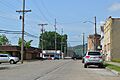
A view of the business district in Yorkville.
-
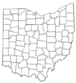
A map showing where Yorkville is located in Ohio.
-
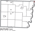
A map highlighting Yorkville's location within Belmont County.
See also
 In Spanish: Yorkville (Ohio) para niños
