Carrollton, Ohio facts for kids
Quick facts for kids
Carrollton, Ohio
|
|
|---|---|
|
Village
|
|

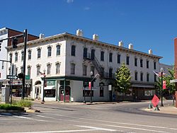
The Van Horn Building in downtown Carrollton
|
|

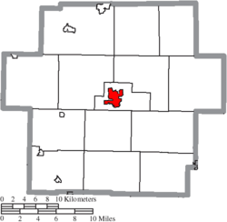
Location of Carrollton in Carroll County
|
|
| Country | United States |
| State | Ohio |
| County | Carroll |
| Township | Center |
| Area | |
| • Total | 2.75 sq mi (7.13 km2) |
| • Land | 2.75 sq mi (7.13 km2) |
| • Water | 0.00 sq mi (0.00 km2) |
| Elevation | 1,168 ft (356 m) |
| Population
(2020)
|
|
| • Total | 3,087 |
| • Estimate
(2023)
|
3,095 |
| • Density | 1,121.73/sq mi (433.10/km2) |
| Time zone | UTC-5 (Eastern (EST)) |
| • Summer (DST) | UTC-4 (EDT) |
| ZIP code |
44615
|
| Area code(s) | 330 |
| FIPS code | 39-12280 |
| GNIS feature ID | 2397564 |
| School District | Carrollton Exempted Village |
| Website | http://www.villageofcarrollton.com |
Carrollton is a small town, called a village, in Ohio, United States. It's the main town, or county seat, of Carroll County, Ohio. In 2020, about 3,087 people lived here. Carrollton is part of the larger Canton–Massillon metropolitan area.
Contents
History of Carrollton
Carrollton was first started on October 4, 1815. It was called "Centreville" back then. This name was chosen because it was located at an important crossroads. These roads connected towns like Steubenville to Canton and New Lisbon to New Philadelphia.
The village became the main town for the new Carroll County. So, its name was changed on February 24, 1834. The name "Carrollton" comes from Charles Carroll of Carrollton. He was the very last person to sign the Declaration of Independence who was still alive.
Many members of the famous Fighting McCooks family lived in Carrollton. This family was well-known during the American Civil War. Their home, the Daniel McCook House, is now a National Historic Place. This means it's an important historical site.
Geography of Carrollton
Carrollton covers a total area of about 2.75 square miles (7.13 square kilometers). All of this area is land.
The village is located where several important roads meet. These include State Route 39 and State Route 43. Other state roads, State Route 9 and State Route 332, also go through the village.
A part of the Wheeling and Lake Erie Railway also runs through Carrollton. This railway line ends at the Carroll County Industrial Park.
Population and People
| Historical population | |||
|---|---|---|---|
| Census | Pop. | %± | |
| 1860 | 721 | — | |
| 1870 | 813 | 12.8% | |
| 1880 | 1,136 | 39.7% | |
| 1890 | 1,228 | 8.1% | |
| 1900 | 1,271 | 3.5% | |
| 1910 | 1,730 | 36.1% | |
| 1920 | 2,192 | 26.7% | |
| 1930 | 2,286 | 4.3% | |
| 1940 | 2,548 | 11.5% | |
| 1950 | 2,658 | 4.3% | |
| 1960 | 2,786 | 4.8% | |
| 1970 | 2,817 | 1.1% | |
| 1980 | 3,065 | 8.8% | |
| 1990 | 3,042 | −0.8% | |
| 2000 | 3,190 | 4.9% | |
| 2010 | 3,241 | 1.6% | |
| 2020 | 3,087 | −4.8% | |
| 2023 (est.) | 3,095 | −4.5% | |
| Sources: | |||
In 2010, there were 3,241 people living in Carrollton. There were 1,347 households, which are groups of people living together. The average number of people in each household was about 2.26.
The average age of people in the village was 42.2 years old. About 22.3% of the residents were under 18 years old. Also, 22.2% of the people were 65 years old or older.
Education in Carrollton
Students in Carrollton attend schools that are part of the Carrollton Exempted Village School District. The schools serving the village are:
- Carrollton Elementary School – This school is for students in grades K-5. It is located at 252 Third St NE.
- Bell-Herron Middle School – This school serves students in grades 6-8. It is also located at 252 Third St NE.
- Carrollton High School – This high school is for older students. It is located at 205 Scio Rd. SW.
Carrollton also has a public library. It is a branch of the Carroll County District Library.
Notable People from Carrollton
Many interesting people have come from Carrollton:
- William Crozier – He was an expert in artillery and an inventor.
- Ephraim R. Eckley – He was a U.S. Representative and a brigadier general in the Civil War.
- George Hemming – He was a professional Baseball player in the 1800s.
- Kirk Lowdermilk – He played American football as an offensive lineman for Ohio State University and the Minnesota Vikings.
- Eddie and Sam Maple – These brothers were famous thoroughbred horse racing jockeys.
- Benjamin F. Potts – He served as the governor of the Montana territory.
See also
 In Spanish: Carrollton (Ohio) para niños
 | Misty Copeland |
 | Raven Wilkinson |
 | Debra Austin |
 | Aesha Ash |


