
Lake Chad facts for kids
Quick facts for kids Lake Chad |
|
|---|---|
 |
|
| Location | Sahelian zone at the conjunction of Chad, Cameroon, Nigeria, and Niger |
| Primary inflows | Chari River, Yobe River, Ngadda River |
| Primary outflows | Bahr el-Ghazal |
| Basin countries | Chad, Cameroon, Nigeria, Niger |
| Surface area | 2,000 km2 (770 sq mi) |
| Max. depth | 2 m (6.6 ft) |
| Islands | Bogomerom Archipelago |
| Settlements |
|
| Official name: Lac Tchad | |
| Designated: | 17 June 2001 |
| Reference #: | 1072 |
| Official name: Partie tchadienne du lac Tchad | |
| Designated: | 14 August 2001 |
| Reference #: | 1134 |
| Official name: Lake Chad Wetlands in Nigeria | |
| Designated: | 30 April 2008 |
| Reference #: | 1749 |
| Official name: Partie Camerounaise du Lac Tchad | |
| Designated: | 2 February 2010 |
| Reference #: | 1903 |
Lake Chad is a large freshwater lake in Africa. It is located where four countries meet: Nigeria, Niger, Chad, and Cameroon. This lake is a very important wetland area in West-Central Africa.
In the 1800s, Lake Chad was much bigger, covering about 28,000 square kilometers. However, since the 1970s, the lake has shrunk a lot. This is mainly because of climate change and people using too much water from the rivers that feed it. Today, its size changes between 2,000 and 5,000 square kilometers.
Contents
Lake Chad's Ancient Past

The area where Lake Chad sits was formed by a dip in the Earth's surface. Long, long ago, during a time called the Quaternary period (which started about 2.6 million years ago), Lake Chad was actually a huge sea!
Scientists call this ancient, giant lake "Mega-lake Chad." At its biggest, it covered about 340,400 square kilometers. It was about 160 meters deep. When it was this full, its water flowed into the Atlantic Ocean.
People started living around Lake Chad as early as 500 BC. Important discoveries from this time include the Sao civilization. Ancient Roman records mention expeditions reaching the lake around 50 AD and 83 AD. They even called it "Hippo and Rhino Lake."
During the Middle Ages, kingdoms grew around Lake Chad. Later, in the 1500s, Arab people settled there. Today, Fulani herders and Hausa farmers still live around the lake.
European Explorers and Colonization
In the 1800s, Europeans became very interested in Africa. Many explorers visited Lake Chad.
- Gustav Nachtigal from Prussia visited and made friends with the rulers of the Bornu Empire.
- Hanns Vischer from Switzerland took many photos of the lake.
- Boyd Alexander from Britain explored the area to understand how the Niger River, Lake Chad, and the Nile River were connected.
By the early 1900s, Britain, France, and Germany had taken control of the Lake Chad area.
Understanding Lake Chad's Geography

The Lake Chad area is like a big bowl in the Earth's surface. It has different parts, including a southern and northern deep area, and a central raised area.
Lake Chad itself is split into two main parts by a shallow area called the Great Barrier. The southern part is a bit deeper than the northern part. When the water level in the south gets high enough, it flows into the north.
The southern part of the lake has open water and areas covered by tall reeds. In the east, sand dunes that are not fully underwater form many small islands. The lake is quite shallow, with an average depth of about 0.5 to 2 meters in the south and 0 to 1.8 meters in the north.
Lake Chad's Climate and Water Levels
The weather around Lake Chad is affected by both land and sea air. In summer, moist air from the sea brings rain. Later in the year, dry air from the land takes over.
The lake area gets about 330 mm of rain each year. The south bank gets more rain (about 560 mm) than the north bank (about 250 mm).
Temperatures are highest in April, sometimes reaching 40°C. The lowest water levels are usually in June and July, and the highest are in November and December. Water temperatures in the lake range from 19°C to 32°C.
How Lake Chad's Water Works

The Lake Chad basin covers about 1 million square kilometers. The main rivers that flow into the lake are the Chari River, Engada River, and Yobe River. The Chari and Logone rivers provide 95% of the lake's water.
Lake Chad stays fresh, not salty, because its water slowly seeps underground. This water travels to the Bodélé Depression, which is about 400 kilometers to the northeast. This process carries away most of the salt. The southwest part of the lake is freshwater, while the northeast is only slightly salty.
The amount of water in Lake Chad changes a lot. It depends on how much rain falls and how much water evaporates. Because it's a shallow lake, even small changes in weather can greatly affect its size.
The lake has shrunk a lot due to dry weather, too much grazing by animals, and people taking water for farming. Global weather patterns like the Atlantic multidecadal oscillation and El Niño–Southern Oscillation also affect rainfall in the region. From the 1960s to the 1980s, the lake's water level dropped by 3 meters compared to earlier averages.
In 1870, Lake Chad was about 28,000 square kilometers. It briefly shrank around 1900 but grew again by the mid-1900s. A big drought hit the area in the late 1960s, causing severe damage in 1972 and 1984. During this time, Lake Chad became much smaller, shrinking to between 2,000 and 5,000 square kilometers.
The lake's area continued to shrink, reaching only 1,756 square kilometers in February 1994. Since then, its size has been more stable, with a slight increase. For example, in July 2015, it was about 2,231 square kilometers.
Lake Chad's Amazing Wildlife

Parts of the Lake Chad area are protected, like the Chad Basin National Park in Nigeria. There are also large wetland areas recognized internationally for their importance.
Many types of plants grow around the lake. In the south, you can find plants like cyperus papyrus. Reeds grow in the saltier northern parts. Floating plants sometimes cover large areas of the water. As water levels have dropped, more permanent plant life has grown. The surrounding forests have changed, now featuring trees like acacias, baobabs, and palms.
Hundreds of bird species live around Lake Chad, either all year or seasonally. These include birds like the northern shoveler, Egyptian goose, and marabou stork. It's a key winter home for many European ducks and wading birds. Over a million ruff birds have been seen on the lake at one time!
In the past, large mammals like red-fronted gazelle, dama gazelle, patas monkey, striped hyena, cheetah, and caracal lived here. African elephants, otters, hippopotamuses, sitatungas, and kobs were found in the wetlands. Sadly, most of these large mammals have been hunted and are now gone. Instead, there are many cattle.
The Lake Chad Basin is home to 179 types of fish. Many of these are also found in the Niger and Nile River Basins. About 84 fish species live in the lake itself. This makes it a very important place for fishing for people in Nigeria, Niger, Chad, and Cameroon. When floods arrive, fish migrate to feed and breed in the rich floodplains.
Life and Development Around Lake Chad


People living near the lake grow crops like sorghum, maize, finger millet, beans, and vegetables. They also collect products from the forest, such as gum arabic, honey, and firewood. However, as forests shrink, these products become harder to find.
Raising animals is also very important. Cattle are the main livestock, but people also raise poultry, goats, sheep, camels, horses, and donkeys. The droughts in the 1970s and 1980s greatly harmed the livestock industry.
Fishing has always been a key way for people to earn a living around the lake. It almost stopped during droughts but started again in the mid-1990s. Most fish are dried, pickled, or smoked to preserve them. A natural mineral called natron is also dug up from the lake's northeast side. It has been traded for a long time, especially in Nigeria.
More than 30 million people live in the Lake Chad Basin. Over 70 different ethnic groups live around the lake, mostly on the south bank. They depend on Lake Chad for water to irrigate their farms, raise animals, and drink.
Since the droughts of the 1970s, new land has appeared at the bottom of the lake. Farmers have started using this land to grow crops like maize, cowpea, rice, and sorghum. However, growing crops that need a lot of water, like rice, has led to problems like salty soil and too many nutrients in the water.
Since 1970, countries in the southern part of the basin have built many dams and projects on the rivers that feed Lake Chad. This has greatly reduced the amount of water flowing into the lake. For example, from 1970 to 1990, the Chari and Logone rivers brought only 55% of the water they did in earlier years. This has harmed fish populations, as their migration patterns are disrupted.
The countries around the lake are also facing extreme poverty. There are growing conflicts between countries and groups of people competing for water and land.
To help manage the lake, Cameroon, Niger, Nigeria, and Chad created the Lake Chad Basin Commission in 1964. The Central African Republic and Libya later joined. This group works to manage Lake Chad's water, protect its environment, and promote peace and development in the region.
There is a plan to bring more water to Lake Chad. It involves building a 2,400-kilometer canal to move water from the Congo River Basin to the Chari River Basin each year. This project would also use dams to generate electricity.
Images for kids
-
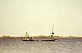
Kanuri tribal fishermen in the 1970s
-
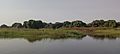
Shore of Lake Chad
-
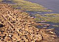
A town on the shores of Lake Chad

.jpg)

See also
 In Spanish: Lago Chad para niños
- Sahel, region in Africa
- Lake Ptolemy, former lake in Sudan
- Aral Sea, lake that has largely dried up
- African humid period, former African climate period
- Sudd, vast swamp in South Sudan
- Inner Niger Delta, an inland delta in Mali
