
Niger facts for kids
Quick facts for kids
Republic of the Niger
République du Niger (French)
|
|
|---|---|
 Coat of arms
|
|
|
Motto:
|
|
|
Anthem: L'Honneur de la Patrie (French)
"The Honour of the Fatherland" |
|
.svg)
Location of Niger (dark green)
|
|
| Capital and largest city
|
Niamey 13°30′49″N 2°06′32″E / 13.51361°N 2.10889°E |
| Official languages | French |
| National languages |
|
| Ethnic groups
(2021)
|
|
| Religion
(2012)
|
|
| Demonym(s) | Nigerien |
| Government | Unitary republic under a military junta |
| Abdourahamane Tchiani | |
|
• CNSP Vice President
|
Salifou Modi |
| Ali Lamine Zeine | |
| Legislature | National Council for the Safeguard of the Homeland |
| Independence
from France
|
|
|
• Republic proclaimed
|
18 December 1958 |
|
• Declared
|
3 August 1960 |
| 26 July 2023 | |
| Area | |
|
• Total
|
1,267,000 km2 (489,000 sq mi) (21st) |
|
• Water (%)
|
0.02 |
| Population | |
|
• 2024 estimate
|
26,342,784 (56th) |
|
• Density
|
12.1/km2 (31.3/sq mi) |
| GDP (PPP) | 2023 estimate |
|
• Total
|
|
|
• Per capita
|
|
| GDP (nominal) | 2023 estimate |
|
• Total
|
|
|
• Per capita
|
|
| Gini (2021) | ▼ 32.9 medium |
| HDI (2022) | low · 189th |
| Currency | West African CFA franc (XOF) |
| Time zone | UTC+1 (WAT) |
| Driving side | right |
| Calling code | +227 |
| ISO 3166 code | NE |
| Internet TLD | .ne |

Niger is a country in western Africa. Its capital city is Niamey. The official language is French. Niger is surrounded by other countries. To the north are Algeria and Libya. To the east is Chad. To the south are Nigeria and Benin. To the west are Burkina Faso and Mali. Niger is a landlocked country, which means it has no coastline or access to the sea. The country gets its name from the Niger River.
Long ago, parts of what is now Niger were controlled by the Mali Empire and the Songhai Empire. Later, France took control of the land. Niger has a population of over 26 million people. Its area is about 1,267,000 square kilometres. A large part of Niger is covered by the Sahara desert.
France colonized Niger during the Scramble for Africa. It became a separate colony in 1922. Niger gained its independence in 1960. Since then, the country has had periods of military rule. Currently, a group called the National Council for the Safeguard of the Homeland is in charge. Niger is considered one of the world's poorest countries.
Contents
Exploring Niger's Geography

Niger is a landlocked country in West Africa. It sits between the Sahara desert and the Sub-Saharan regions. Niger shares borders with seven other countries. These include Nigeria and Benin to the south. To the west are Burkina Faso and Mali. Algeria and Libya are to the north. Chad is to the east.
Niger is located between 11° and 24°N latitude and 0° and 16°E longitude. Its total area is about 1,267,000 square kilometers. Only 300 square kilometers of this is water. This makes Niger the 21st largest country in the world. It is less than twice the size of France.
The country's total border length is about 5,697 kilometers. The longest border is with Nigeria, at 1,497 kilometers. The shortest border is with Benin, at 266 kilometers.
The lowest point in Niger is the Niger River, which is 200 meters above sea level. The highest point is Mont Idoukal-n-Taghès. This mountain is in the Aïr Mountains and stands at 2,022 meters high.
Niger's land is mostly flat desert plains and sand dunes. In the south, you can find flat to rolling savanna. The northern parts have hills.
Niger's Climate

The climate in Niger is mostly hot and dry, especially in the desert areas. This dry climate can lead to more frequent fires in some regions. In the southern parts of the country, near the Niger River, the climate becomes tropical.
Amazing Wildlife and Nature

Niger is home to many different types of natural environments. These include savannas, woodlands, and desert areas.
The northern parts of Niger are covered by deserts and semi-deserts. Here, you might find animals like addax antelopes, scimitar-horned oryx, and gazelles. In the mountains, there are Barbary sheep. The Aïr and Ténéré National Nature Reserve was created to protect these animals.
The southern parts of Niger have natural savannas. The W National Park is a very important area for wildlife in West Africa. It is part of a larger protected area called the WAP Complex. This park is home to the West African lion and one of the last groups of Northwest African cheetahs.
Other animals you can find in Niger include elephants, buffaloes, roan antelopes, kob antelopes, and warthogs. The West African giraffe lives further north. It is one of the last places where this type of giraffe can be found.
Niger faces some environmental challenges. These include farming practices that harm the land. There is also illegal hunting and bush fires. People are also building on the flood plains of the Niger River. Dams built on the Niger River in nearby countries can reduce water flow. This affects the environment in Niger. There are also not enough people to protect wildlife in the parks.
To help the environment, people in Niger practice something called Farmer-managed natural regeneration. This helps to grow more food and trees. It also makes the land stronger against extreme weather.
How Niger is Governed
.jpg)
Niger's current system of government was set up in 2010. It is a semi-presidential system. This means there is a president who is elected by the people for five years. The president then chooses a prime minister. Both the president and prime minister share the job of leading the country. However, since July 2023, the country has been led by a military group.
Major Cities and Towns
|
Largest cities or towns in Niger
According to the 2012 Census |
||
|---|---|---|
| Rank | Name | Pop. |
| 1 | Niamey | 978,029 |
| 2 | Maradi | 267,249 |
| 3 | Zinder | 235,605 |
| 4 | Tahoua | 117,826 |
| 5 | Agadez | 110,497 |
| 6 | Arlit | 78,651 |
| 7 | Birni-N'Konni | 63,169 |
| 8 | Dosso | 58,671 |
| 9 | Gaya | 45,465 |
| 10 | Tessaoua | 43,409 |
Niger's Economy

Niger's economy relies on growing crops for food, raising livestock, and mining. The country has some of the world's largest deposits of uranium. However, Niger faces challenges like droughts and the desert expanding. Its population is also growing quickly. A decrease in the global demand for uranium has also affected the economy.
People and Society
Niger's Population

Niger's population has grown very fast. In 1960, there were 1.7 million people. Now, the population is over 26 million. The population growth rate is one of the highest in the world. This rapid growth is a concern for the government and international organizations.
Different Ethnic Groups
Niger is home to many different ethnic groups, just like most West African countries. The main groups are:
- Hausa (53.0%)
- Zarma-Songhai (21.2%)
- Tuareg (10.4%)
- Fula (9.9%)
- Kanuri Manga (4.4%)
- Other smaller groups make up the rest.
Languages Spoken in Niger
French is the official language of Niger. It was inherited from the time when France ruled the country. Most people who have gone to school speak French as a second language. It is used for government and business. Niger is a member of the Organisation internationale de la Francophonie, which promotes French language and culture.
Niger also has ten official national languages. These include Arabic, Buduma, Fulfulde, Gourmanchéma, Hausa, Kanuri, Zarma & Songhai, Tamasheq, Tassawaq, and Tebu. Each of these languages is mainly spoken by its associated ethnic group.
Niger's Rich Culture


Niger's culture is very diverse. This is because it was formed from different cultural areas by French colonial rule in the 20th century. Before colonialism, there were four main cultural areas:
- The Zarma lived in the Niger River valley in the southwest.
- The northern part of Hausaland was along the southern border with Nigeria.
- The Lake Chad basin and Kaouar in the east had Kanuri farmers and Toubou herders.
- The Tuareg nomads lived in the Aïr Mountains and the Sahara desert in the north.
Each of these groups, along with smaller ones like the Wodaabe Fula, brought their own traditions to Niger. Governments have tried to create a shared national culture. However, this has been slow because each community has its own history. Also, groups like the Hausa, Tuareg, and Kanuri are part of larger groups that live across borders in other countries.
For a long time, the capital city Niamey and the Zarma people had a lot of influence in politics. Meanwhile, many Hausa people living near the Nigerian border often felt more connected to Hausaland in Nigeria than to Niamey.
Landmarks

- The Agadez Grand Mosque: A Towering Mud-Brick Marvel
One of the most striking landmarks in Niger is the Agadez Grand Mosque. Located in the historic city of Agadez, this mosque is truly special because it's built almost entirely out of mud bricks! This incredible minaret stands about 27 meters (around 89 feet) tall. That's as tall as a nine-story building! The original mosque was built way back in 1515, over 500 years ago! It was later rebuilt in a similar style in 1844. It's a fantastic example of traditional Sahelian architecture, which uses local materials like mud, wood, and straw. It shows how people in this region have built amazing structures for centuries, perfectly suited to their environment. The city of Agadez itself, including the mosque, is a UNESCO World Heritage site, meaning it's recognized as having outstanding universal value to humanity.
- Air and Ténéré Natural Reserves: A Desert Masterpiece
The Air and Ténéré Natural Reserves are one of the largest protected areas in Africa, covering a massive 7.7 million hectares (about 19 million acres). That's bigger than many countries!
This vast area combines two different landscapes: the Air Mountains and the Ténéré Desert. One of the most fascinating things about these reserves is the ancient rock art found there. People who lived in this area thousands of years ago carved and painted pictures on rocks, showing animals like giraffes, elephants, and even people. It's like a giant outdoor art gallery from the past! Like Agadez, this entire area is a UNESCO World Heritage site, recognized for its incredible natural beauty, unique geology, and important archaeological sites.
- W National Park: Where Wildlife Roams Free
W National Park is a large wildlife reserve that is shared by three countries: Niger, Burkina Faso, and Benin. It gets its name from the "W" shape that the Niger River makes as it flows through the park. The part of the park in Niger is in the southwest of the country. This park is a very important home for many large mammals in West Africa. You can find African elephants, West African giraffes, hippos, buffalo, antelopes like roan and hartebeest, and even predators like lions and cheetahs. It's also a paradise for birdwatchers, with hundreds of different bird species.
W National Park is crucial for protecting these animals and their habitats. It's part of a larger protected area called the W-Arly-Pendjari Complex, which is also a UNESCO World Heritage site. This means it's a globally important place for biodiversity.
- Zinder Old Town (Birni): A Glimpse into the Past

Step back in time when you visit the Old Town of Zinder, also known as Birni. Zinder was once a very important trading city and even served as the capital of Niger for a while.
Birni is the historic heart of Zinder, filled with traditional houses, narrow streets, and a rich history. A key landmark here is the Sultan's Palace, which has been the home of the local traditional ruler for centuries. It's a beautiful example of traditional Hausa architecture, with decorated walls and courtyards.
Zinder was a major stop on the trans-Saharan trade routes, where goods like salt, gold, and kola nuts were exchanged. This history has shaped its culture and architecture.
The buildings in Birni are often made of mud and have unique designs, reflecting the local Hausa culture. Walking through its streets feels like exploring a living museum.
- The Niger River: The Lifeline of West Africa
Not all landmarks are buildings or mountains; some are natural wonders that are essential for life. The Niger River is one such landmark, and it's incredibly important to Niger and many other West African countries.
The Niger River is the third-longest river in Africa, stretching about 4,180 kilometers (2,600 miles). It has a very unusual path, forming a giant "boomerang" shape. It starts in Guinea, flows northeast into the Sahara Desert, then makes a sharp turn southeast, eventually emptying into the Atlantic Ocean in Nigeria.
For Niger, a country that is mostly desert, the river is a true lifeline. It provides water for drinking, farming, and fishing. Many towns and cities, including the capital city of Niamey, are located along its banks.
The river has been used for transportation for thousands of years, with boats carrying people and goods. The river and its surrounding wetlands are home to a variety of wildlife, including hippos, crocodiles, and many types of fish and birds.
- Koure Giraffe Reserve: Home of the Gentle Giants
Just a short drive from Niger's capital, Niamey, you can find a very special place dedicated to protecting one of Africa's most iconic animals: the giraffe!
The Koure Giraffe Reserve is a protected area specifically established to conserve the last remaining population of West African giraffes (also known as Giraffa camelopardalis peralta).
These giraffes are special because they have lighter, more distinct patches compared to other giraffe species. They are also one of the most endangered giraffe subspecies in the world.
Thanks to conservation efforts by the government and local communities, the number of these giraffes has grown significantly over the years, from just a few dozen in the 1990s to several hundred today.
It's a wonderful place to see these magnificent animals in their natural habitat, learning about their lives and the importance of protecting them.
Festivals and Cultural Events
Guérewol Festival
The Guérewol festival is a special Wodaabe cultural event. It happens every year in places like Abalak or In-Gall. During this festival, young Wodaabe men dress up in fancy clothes and paint their faces. They dance and sing in lines to impress young women who are looking for a partner. The Guérewol festival is famous around the world. It has been shown in magazines like National Geographic.
Cure Salée Festival
"La Cure salée" (which means "Salt Cure") is an annual festival for Tuareg and Wodaabe nomads. It takes place in In-Gall and celebrates the end of the rainy season. For three days, the festival features a parade of Tuareg camel riders. There are also camel and horse races, songs, dances, and storytelling.
Education in Niger

The ability to read and write, known as the literacy rate, is very low in Niger. In 2005, it was estimated that only about 28.7% of adults could read and write. This was 42.9% for males and 15.1% for females. Primary education in Niger is required for six years. However, not many children, especially girls, attend school regularly. Children often have to work instead of going to school. This is especially true during planting or harvest times. Some children also attend religious schools called madrasas.
Related pages
Images for kids
-
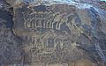
Rock engraving showing herds of giraffe, ibex, and other animals in the southern Sahara near Tiguidit, Niger
-
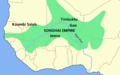
Map of the Songhai Empire, overlaid over modern boundaries
-
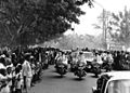
President Hamani Diori and visiting German President Heinrich Lübke greet crowds on a state visit to Niamey, 1969. Diori's single party rule was characterised by "good" relations with the West and a preoccupation with foreign affairs.
-
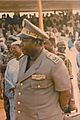
Ali Saibou, President 1987–93, helped oversee the transition from military to civilian rule
-
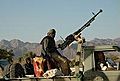
A Tuareg rebel fighter in northern Niger during the Second Tuareg Rebellion, 2008
-
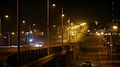
Niamey at night
-
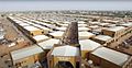
Dolé Market
-
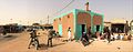
Small mosque in Filingue


See also
 In Spanish: Níger para niños
