
Aïr Mountains facts for kids
Quick facts for kids Aïr Mountains |
|
|---|---|
| Aïr Massif, Ayr | |

The Timia Valley, in the Aïr Mountains
|
|
| Highest point | |
| Peak | Mont Idoukal-n-Taghès |
| Elevation | 2,022 m (6,634 ft) |
| Dimensions | |
| Area | 84,000 km2 (32,000 sq mi) |
| Naming | |
| Native name | Error {{native name}}: an IETF language tag as parameter {{{1}}} is required (help) |
| Geography | |

Location in Niger
|
|
| Country | |
| State/Province | Agadez Region |
| Range coordinates | 18°16.6′N 8°0′E / 18.2767°N 8.000°E |
The Aïr Mountains are a large group of mountains in northern Niger, found in the middle of the Sahara desert. They are also known as the Aïr Massif. These mountains rise high above the desert, reaching over 1,800 meters (5,900 feet) in some places. They cover a huge area of about 84,000 square kilometers (32,000 square miles).
Even though they are in the desert, the Aïr Mountains have a special climate. This climate is similar to the Sahel region, which is usually found much further south. This allows many different kinds of plants and animals to live here. It also supports communities of people who farm and raise animals. The area is also famous for its amazing rock formations and ancient sites.
Contents
How the Aïr Mountains Formed

The Aïr Mountains are made of very old rocks. These rocks formed over millions of years, from the Precambrian era to more recent times. They are mostly made of a dark-colored rock called granite. This is unusual because most granite is light-colored. In the Sahara Desert, these dark mountains stand out against the sand.
The area has high plateaus, mountain ranges, and wide, sandy valleys. There are also dry riverbeds called wadis. These wadis once had rivers flowing through them. Today, some of these valleys still have underground water. This water creates oases and helps plants grow throughout the year.
The Aïr Mountains have nine almost round-shaped mountain groups. These groups rise from a rocky plateau. Sand dunes and plains of the Ténéré Desert surround them to the east. The highest point is Mont Idoukal-n-Taghès, which is 2,022 meters (6,634 feet) tall. Other important peaks include Mont Tamgak and Mont Greboun.
The mountains also have signs of past volcano activity. There are old volcanic craters and lava flows. One of the largest systems of circular rock formations in the world is found here. Near Izouzaoenehe, you can find the Blue Mountains, which are made of marble.
Weather and Water in Aïr

The Aïr Mountains are quite high, usually between 500 and 900 meters (1,600 to 3,000 feet) above sea level. Because of this height, they get more rain than the surrounding desert. They receive about 50 to 160 millimeters (2 to 6 inches) of rain each year. This makes the Aïr a greener area, especially after the rainy season in August and September.
The climate here is called Sahel climate. This is the same type of climate found in regions much further south. Most of the mountains are bare, meaning they don't have much plant life. However, the dry river valleys, called "Kori" by the local Hausa people, collect rainwater. This water forms pools called gueltas, like the one near the town of Timia. These oases provide food for animals and allow some farming.
The high Bagzane plateau in the central Aïr gets enough rain for a lot of farming. But many other parts of the region have no plants at all. These areas, with their volcanic rocks and rocky fields, look like they belong on another planet.
Plants of the Aïr Mountains
Over 430 different types of plants have been found in the Aïr Mountains. The Aïr Mountains connect the plants of the Sahara with those of the Sahel. Also, because the mountains are so tall, they create special conditions. These conditions allow plants from the Sudanian and Mediterranean regions to grow here too.
Scientists have studied the plants in the Aïr for many years. Common trees include the Vachellia tortilis and Balanites aegyptiaca. Near the temporary rivers (koris), you can find Vachellia nilotica, Faidherbia albida, and the Hyphaene thebaica palm. Date palm trees are also grown here.
Long periods of dry weather and very little rain make it hard for plants to grow in the Aïr. Also, many grazing animals eat the young trees. This means not enough new trees are growing. However, scientists have found that young trees grow better when they are protected by large clumps of a grass called Panicum turgidum. This discovery could help local people plant more trees.
Some rare plants, like a type of olive tree called Olea europaea subsp. laperrinei, have been found in the higher parts of the mountains. These small groups of olive trees are the southernmost place where this species grows.
Studies on the highest peak, Mont Idoukal-n-Taghès, found plants never seen in Niger before. These include tropical plants that don't like dry conditions. Some ferns were also found for the first time in the Aïr. This shows that the mountains have a unique climate that helps many different kinds of plants grow. Because these plants are so isolated in the desert, they are very important to protect.
People of the Aïr Region
The town of Agadez is the main center of the Aïr region. It is in the heart of the Tuareg country. For a long time, many Tuareg people in Aïr lived a nomadic life. They moved around with their camels and goats. They used the milk, meat, and skins from these animals to make food and crafts.
People who lived in settled oases were often farmers. They grew date palms in places like Timia, Aouderas, and Tabelot. Traditionally, they traded their farm products for clothes or salt. The salt was brought by camel caravans, called Azalai, from distant oases like Bilma and Fachi to the east.
Aïr's Ancient History

The Aïr Mountains are famous for their rock art. This art dates back from 6000 BCE to about 1000 CE. During a time when Africa was much wetter, the region was a green area with grasslands. The rock art shows pictures of cattle and large animals, proving this. But around 3000 BC, the area started to become a desert. This caused the Tuareg to move into the region from further north.
Later art shows scenes of war, with horses and chariots. One very famous carving is the "Dabous Giraffes". These are five-meter-high carvings discovered in 1999. Most of the cave art in the region is carved into stone. Early carvings were made with sharp rocks. After about 1200 BC, people might have used metal tools.
Recent History of Aïr
When Arab groups moved south in the 700s and 800s, there were Hausa people in the southern Aïr. Different Tuareg groups have controlled the area since at least the 1100s. In the early 1400s, Agadez was an important outpost of the Songhai Empire. In the 1500s, the area became part of the Tuareg Sultanate of Agadez. This lasted until the French arrived in the late 1800s.
The arrival of the French caused problems for the Tuareg groups. There was fighting among them and resistance against the French. In the 1880s, raids by other groups increased. In 1917, a Tuareg leader named Ag Mohammed Wau Teguidda Kaocen led a rebellion against the French. Many towns were destroyed during this conflict. After the French took back Agadez, they punished the region severely. Many places that used to have a lot of people became empty.
In the mid-1900s, farming and raising animals became more common. But severe dry periods in the 1970s and 1980s stopped this growth. As the towns of Agadez and Arlit grew, the smaller towns in the Aïr shrank.
From 1990 to 1995, there was another rebellion. The government's harsh actions caused many villages in the Aïr to lose their people. Peace returned in the mid-1990s. The uranium mines near Arlit also brought new growth to the region. Many small towns earned money from tourism.
However, in 2004, a locust invasion destroyed many gardens. This led to food shortages and contributed to the Second Tuareg Rebellion from 2007 to 2009. Unrest continues in the region, which has stopped the tourism industry from growing.
Images for kids
-
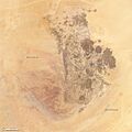
Annotated view, showing the Talak to the west and the Tenere desert to the east of the Air Mountains.
-
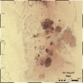
A closer look at the Aïr Mountains.
-
A map showing the height of the land in the Aïr Mountains.
-

A detailed map of the northern part of the Aïr Mountains.
-
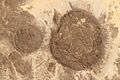
Circular granite massifs (dark areas) in the Aïr Mountains. A volcanic crater is visible at the bottom left.


See also
 In Spanish: Montañas de Air para niños
- Aïr and Ténéré National Nature Reserve
- Ténéré
- World Heritage Sites in Danger
