
Burkina Faso facts for kids
Quick facts for kids
Burkina Faso
|
|
|---|---|
 Coat of arms
|
|
|
Anthem: Ditanyè
|
|
.svg)
Show globe 
Show map of Africa |
|
| Capital and largest city
|
Ouagadougou 12°22′N 1°32′W / 12.367°N 1.533°W |
| Official languages |
|
| Working languages | |
| Ethnic groups
(2010 est.)
|
|
| Demonym(s) |
|
| Government | Unitary republic under a military junta |
|
• Interim President and MPSR President
|
Ibrahim Traoré |
| Apollinaire Joachim Kyélem de Tambèla | |
| Legislature | Transitional Legislative Assembly |
| History | |
|
• Republic of Upper Volta proclaimed
|
11 December 1958 |
|
• Independence from France
|
5 August 1960 |
|
• 1966 Upper Voltan coup d'état
|
3 January 1966 |
|
• 2014 Burkina Faso uprising
|
28 October – 3 November 2014 |
|
• Jan 2022 Burkina Faso coup d'état
|
23–24 January 2022 |
|
• Sep 2022 Burkina Faso coup d'état
|
30 September 2022 |
| Area | |
|
• Total
|
274,223 km2 (105,878 sq mi) (74th) |
|
• Water (%)
|
0.146% |
| Population | |
|
• 2023 estimate
|
22,489,126 (58th) |
|
• Density
|
64/km2 (165.8/sq mi) |
| GDP (PPP) | 2023 estimate |
|
• Total
|
|
|
• Per capita
|
|
| GDP (nominal) | 2023 estimate |
|
• Total
|
|
|
• Per capita
|
|
| Gini (2021) | medium |
| HDI (2022) | low · 185th |
| Currency | West African CFA franc (XOF) |
| Time zone | UTC+00:00 |
| Date format | dd/mm/yyyy |
| Driving side | right |
| Calling code | +226 |
| ISO 3166 code | BF |
| Internet TLD | .bf |

Burkina Faso is a landlocked country in West Africa, which means it is surrounded by other countries and has no coast. It is bordered by Mali, Niger, Benin, Togo, Ghana, and the Ivory Coast. The country has a population of over 20 million people.
Its capital and largest city is Ouagadougou. The people of Burkina Faso are known as Burkinabè. The country was once called the Republic of Upper Volta. In 1984, President Thomas Sankara changed its name to Burkina Faso, which means "Land of Honest Men."
The largest ethnic group is the Mossi people. They settled in the area long ago and created powerful kingdoms. In the late 1800s, France colonized the area. Burkina Faso gained full independence in 1960. Since then, the country has faced many challenges, including government changes and droughts.
In recent years, Burkina Faso has dealt with violence from armed groups, which has caused many people to leave their homes. The country is led by a military government that took power in 2022.
Burkina Faso is a developing country with a strong culture. It is rich in natural resources like gold, manganese, and copper. The country is known for its traditional art and music.
Contents
What does the name "Burkina Faso" mean?
The country used to be called the Republic of Upper Volta because of its location on the Volta River.
On August 4, 1984, President Thomas Sankara gave the country its new name: "Burkina Faso." The name comes from two of the country's major languages. "Burkina" is from the Mossi language and means "upright" or "honest," showing the pride of the people. "Faso" is from the Dioula language and means "fatherland." Together, the name means "land of the honest people."
History
Early Kingdoms

The first people in this area were hunter-gatherers who lived there as early as 14,000 BCE. People started farming around 3600 BCE. By 1200 BCE, people in the region had learned to work with iron to make tools and weapons.
Between the 8th and 15th centuries, different groups of people, including the Mossi, moved into the area. The Mossi created several powerful kingdoms, like Ouagadougou and Yatenga. These kingdoms were known for their skilled cavalry. They often raided nearby territories, including the famous city of Timbuktu.
French Colony to Independence

In the 1890s, during the Scramble for Africa, France began to take control of the region. By 1898, most of what is now Burkina Faso was a French protectorate. The French made it part of their large colony called French West Africa.
Life under French rule was difficult for the local people. They were not treated as equals, and many were forced to work on projects like building roads or growing cotton for export. Many men from the area were also made to fight for France in World War I.
In 1919, the colony was officially named French Upper Volta. After World War II, people across Africa began to demand freedom. On December 11, 1958, Upper Volta became a self-governing republic within the French Community. It gained full independence from France on August 5, 1960.
Modern Burkina Faso

After independence, the country experienced many changes in government. One of its most famous leaders was Thomas Sankara, who became president in 1983. He started programs to improve education, plant trees to stop the desert from spreading, and build roads and railways. He was also known for promoting women's rights.
Sankara was killed in 1987 in a coup led by Blaise Compaoré, who then ruled for 27 years. In 2014, large protests forced Compaoré to leave office. Since then, the country has had several more changes in leadership. In 2022, the military took control of the government.
Government and Politics

Burkina Faso is currently governed by a military leadership. Before 2022, the country had a constitution and a government with a president and a parliament called the National Assembly. The president was elected for a five-year term.
The government is divided into 13 regions, which are further split into 45 provinces and 301 smaller departments. This system helps manage the country at a local level.
Geography and Climate

Burkina Faso is a mostly flat country. The landscape is a wide, gently rolling plain with a few hills. In the southwest, there is a sandstone mountain range where the country's highest point, Ténakourou, is located.
The country gets its former name, Upper Volta, from three rivers that cross it: the Black Volta, the White Volta, and the Red Volta. Water can be scarce, especially in the northern part of the country.
Climate

Burkina Faso has a tropical climate with two main seasons: a rainy season and a dry season.
- The rainy season lasts from about May to September.
- The dry season features a hot, dry wind from the Sahara Desert called the harmattan.
The country has three climate zones. The north is the driest, part of the Sahel region bordering the Sahara. The south is the wettest and coolest zone, with more rainfall each year.
Wildlife

Burkina Faso is home to many wild animals. It has one of the largest elephant populations in West Africa. You can also find lions, leopards, cheetahs, and African wild dogs.
The country has four national parks to protect its animals and plants. The most famous is the W National Park, which it shares with Benin and Niger.
Economy
.svg)
Most people in Burkina Faso work in agriculture. They raise animals like cattle and grow crops such as sorghum, millet, corn, peanuts, rice, and cotton.
The country's biggest export is gold. Burkina Faso is one of the largest gold producers in Africa. It also has other natural resources like manganese, zinc, and copper.
The official currency is the West African CFA franc, which is used by several other countries in West Africa.
People and Culture
Burkina Faso has a population of over 20 million people from many different ethnic groups. The largest group is the Mossi people, who make up about half of the population. They are known for their rich history and traditions.
Languages
Many languages are spoken in Burkina Faso. The official language is French, used in government and schools. However, most people speak one of the 60 local languages. The most common is the Mooré language, spoken by about half the population. Other widely spoken languages include Fula and Dioula.
Religion

The main religion in Burkina Faso is Islam, practiced by about 64% of the people. About 26% of the population is Christian, mostly Roman Catholic. Around 9% follow traditional African beliefs, which often involve honoring ancestors and nature spirits.
Education

Education is divided into primary, secondary, and higher education. Going to school can be expensive for many families. The government has worked to make school more affordable, especially for girls, to help more children get an education.
The country has several universities, including the University of Ouagadougou. However, Burkina Faso still has one of the lowest literacy rates in the world, meaning many adults cannot read or write.
Cuisine

The food in Burkina Faso is similar to other West African countries. Main staple foods include sorghum, millet, rice, and corn. These are often served with sauces made from peanuts, okra, or vegetables. Chicken and fish are common sources of protein.
A popular drink is Banji, or palm wine, which is made from the sap of palm trees. Another is Zoom-kom, a non-alcoholic drink made from grain and water.
Arts and Festivals

Burkina Faso has a vibrant arts scene. It is famous for its traditional masks, which are used in dances and ceremonies. The country also hosts several major cultural events:
- FESPACO (Panafrican Film and Television Festival of Ouagadougou) is the largest African film festival, held every two years.
- SIAO (International Art and Craft Fair) is a huge fair for African handicrafts, also held every two years.
- FESTIMA is a festival in the town of Dédougou that celebrates traditional masks.
Sports

Football (soccer) is the most popular sport. The national team is nicknamed "Les Etalons," which means "The Stallions." In 2013, the team made it to the final of the Africa Cup of Nations.
At the 2020 Summer Olympics, athlete Hugues Fabrice Zango won a bronze medal in the men's triple jump. It was the first-ever Olympic medal for Burkina Faso.
Images for kids
-
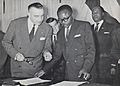
Maurice Yaméogo, the first President of Upper Volta, examines documents for the country's independence in 1960.
-

The cavalry of the Mossi Kingdoms were experts at raiding deep into enemy territory.
-
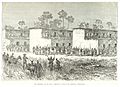
Armed men prevent French explorer Louis-Gustave Binger from entering the city of Sia in 1892.
-

The capital, Ouagadougou, in 1930.
-
Damage caused by floods in Dourtenga in 2007.
-
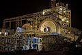
Processing facilities at the Essakane Gold Mine.
-

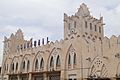
The Grand marché (main market) in Koudougou, Burkina Faso.
-
The railway station in Bobo Dioulasso was built during the colonial era.
-

A Burkinabè Tuareg man in Ouagadougou.
-

Malika Ouattara is a famous slam poet in Burkina Faso.
-

Painted gourds made by an artisan in Ouagadougou.
-
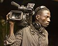
A cameraman in Ouagadougou, Burkina Faso in 2010.


.jpg)


.jpg)


See also
 In Spanish: Burkina Faso para niños
