Timbuktu facts for kids
Quick facts for kids
Timbuktu
Tumbutu (Koyra Chiini Songhay)
Tin Bukt (Tamashek) Himba
|
|
|---|---|
|
City
|
|
| Names transcription(s) | |
| • Tamashek | ⵜⵏⵀⵗⵜ تِينْ بُكْتْ |
| • Koyra Chiini | تُمْبُتُ |
|
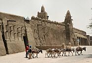
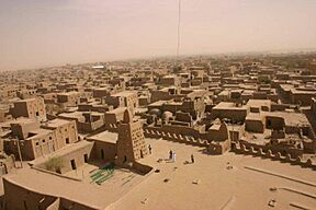
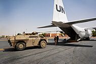
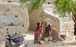
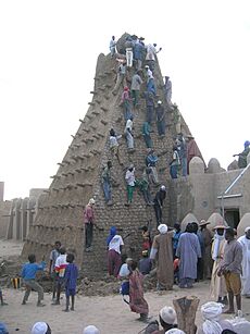
Left to right: Djinguereber Mosque, Sankore Madrasah, Aerial view of Timbuktu, The market of Timbuktu, Fennek in Timbuktu airport.
|
|
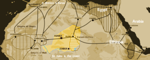
Map showing main trans-Saharan caravan routes c. 1400. Also shown are the Ghana Empire (until the 13th century) and 13th – 15th century Mali Empire, with the western route running from Djenné via Timbuktu to Sijilmassa. Present day Niger in yellow.
|
|
| Country | |
| Region | Tombouctou Region |
| Cercle | Timbuktu Cercle |
| Settled | 5th century BCE |
| Area | |
| • Land | 21 km2 (8 sq mi) |
| Elevation | 261 m (856 ft) |
| Population
(2009)
|
|
| • Total | 54,453 |
| Climate | BWh |
| UNESCO World Heritage Site | |
| Criteria | Cultural: ii, iv, v |
| Inscription | 1988 (12th Session) |
| Endangered | 1990–2005; 2012–present |
Timbuktu is an ancient city in Mali, a country in West Africa. It is located about 20 kilometers (12 miles) north of the Niger River. Timbuktu is the capital of the Tombouctou Region and had a population of 54,453 people in 2009.
Long ago, people lived in this area even before the city became famous. Timbuktu started as a place where people stayed only during certain seasons. It became a permanent settlement in the early 1100s. The city grew very rich because of its location on important trade routes. Traders exchanged salt, gold, and ivory here.
Timbuktu became a major Islamic city and a center for learning. Many scholars and traders came to live there. It became part of the Mali Empire in the early 1300s. Later, the Tuareg people ruled for a short time. Then, the powerful Songhai Empire took control in 1468.
In 1591, an army from Morocco defeated the Songhai. They made Timbuktu their capital. A new ruling group, the Arma people, took over. Timbuktu was famous for its many Islamic scholars and a huge trade in books. It was a major learning center in Africa, especially with the Sankore Madrasah, an Islamic university.
Famous writers like Leo Africanus wrote about the city. Their stories made Europeans think Timbuktu was a mysterious and very rich place. After its golden age, the city slowly declined. Different groups ruled until the French took over Mali in 1893. Mali became an independent country in 1960.
Recently, Timbuktu has faced problems from extremist groups. Some cultural sites were destroyed. But local people and international groups are working hard to protect its history. The city's population has also decreased because of these issues.
Contents
- What's in a Name?
- Early Settlements in Timbuktu
- Timbuktu's Rich History
- Timbuktu's Geography
- Timbuktu's Economy
- Timbuktu in Old Stories
- Arts and Culture in Timbuktu
- Education and Learning
- Languages Spoken in Timbuktu
- Getting Around Timbuktu
- Famous People from Timbuktu
- Sister Cities
- Images for kids
- See also
What's in a Name?
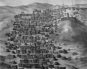
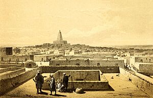
The name Timbuktu has been spelled in many ways over the years. Some old spellings include Tenbuch and Thambet. Today, the French often spell it 'Tombouctou'. In English, 'Timbuktu' is now widely used.
The exact meaning of the name Timbuktu is still debated. Here are a few ideas:
- Songhay origin: Some believe the name comes from two Songhay words. One idea is tin (wall) and butu (Wall of Butu). Another idea is that Tùmbutu means "hole" or "womb" in the Songhay language. This might refer to the city being built in a hollow area.
- Berber origin: Some historians think the name is Berber. It could come from tin (place of) and bouctou (a small dune). So, Timbuktu might mean "place covered by small dunes."
- Named after a person: A 17th-century writer, Abd al-Sadi, said the city was named after a slave woman called Timbuktu. She looked after the belongings of the Tuareg people. Her name meant "the one having a lump" in their language.
- Hidden place: Another idea is that the name comes from a word meaning "to be distant" or "hidden." This could refer to the city's location in a slight dip in the land.
Scientists have not found very old remains in the city. This makes it hard to know for sure who founded the city and where its name came from.
Early Settlements in Timbuktu
Scientists have found signs of older settlements near Timbuktu. These date back to the Iron Age, even before the city was officially founded. Digging in Timbuktu itself is hard because thick layers of sand cover old remains.
However, archaeologists have found pottery pieces on the surface in nearby areas. In 1984, researchers found several Iron Age sites. These were along an old river system east of the modern city.
Between 2008 and 2010, archaeologists dug up a site southeast of Timbuktu. They found that people first lived there around 500 BC. This settlement grew during the first thousand years AD. It then ended around the late 10th or early 11th century AD.
Timbuktu's Rich History
Timbuktu is known as a faraway, mysterious place. But it was once a very powerful trading city. It was also a major center for learning in the medieval world. Timbuktu has had many rulers. Its golden age was under the Mali Empire in the 13th and 14th centuries.
The famous Malian ruler, Mansa Musa, brought great fame to Timbuktu. He started a university for Islamic learning there. This university taught many subjects, not just Islamic studies. Students learned history, law, science, and especially medicine. Mansa Musa also made Timbuktu known to the rest of the medieval world. His journey to Mecca inspired Arab travelers to visit North Africa. Europeans did not reach the city until much later. The long and difficult journey made the city seem even more mysterious.
Timbuktu became wealthy from local gold and salt mining. It also profited from the trans-Saharan slave trade. Gold was very valuable in the Mediterranean region. Salt was popular south of the city. But Timbuktu's best asset was its location. The city is close to the Niger River, which provides good land for farming. It is also near the Sahara Desert, offering easy trade routes. Timbuktu was a meeting point for North, West, and Central Africa. Because of this, it became a mix of many cultures.
The Mali Empire started to decline in the mid-1400s. The Songhai Empire then rose to power. Timbuktu was briefly ruled by the Tuaregs before the Songhai took over. The city generally thrived even with these changes. But then, the Moroccans invaded the Songhai Empire in 1590. They occupied Timbuktu in 1591 after the Battle of Tondibi.
In 1593, many university teachers were killed or sent away. This was because they were seen as disloyal to the new rulers. Trade also declined because new sea routes across the Atlantic became available. This caused Timbuktu to lose its importance. It was not until the 1890s that Timbuktu became part of the French colony of Mali. In 1960, it became part of the independent nation of Mali.
Today, Timbuktu's population is much smaller than its peak of 100,000 people in the medieval period. The city has faced a lot of poverty for many years. It now relies on government help to survive.
Recent Challenges in Timbuktu
On August 8, 2023, Timbuktu was completely blocked off by an armed group. This made poverty worse and led to food shortages. About 33,000 people left the city and nearby areas. Around 1,000 people fled to Mauritania. This blockade began after the United Nations mission in Mali left the country.
Timbuktu's Geography

Timbuktu is on the southern edge of the Sahara desert. It is about 15 kilometers (9 miles) north of the main channel of the River Niger. Sand dunes surround the town, and the streets are covered in sand.
The port of Kabara is 8 kilometers (5 miles) south of Timbuktu. It is connected to a part of the river by a 3-kilometer (2-mile) canal. This canal used to be filled with sand. But in 2007, it was cleared as part of a project.
The Niger River floods every year. This happens because of heavy rain in the areas where the Niger and Bani rivers start. These rains are heaviest in August. But the floodwater takes time to travel down the river. In Timbuktu, the flood lasts longer and usually reaches its highest point in late December.
In the past, the flooded area was much larger. In years with heavy rain, floodwater would reach the western parts of Timbuktu itself. A small waterway west of the town was shown on old maps. Between 1917 and 1921, the French dug a narrow canal. This connected Timbuktu with Kabara. Over the years, this canal filled with sand. But in 2007, it was dug out again. Now, when the Niger River floods, Timbuktu is connected to Kabara again.
Kabara can only be used as a port from December to January. This is when the river is fully flooded. When water levels are lower, boats dock at Korioumé. Korioumé is linked to Timbuktu by an 18-kilometer (11-mile) paved road.
Timbuktu's Climate
Timbuktu has a hot desert climate. The weather is very hot and dry for most of the year. Most of the city's rain falls between June and September. This is due to a weather system called the Intertropical Convergence Zone.
Temperatures change a lot between day and night in the dry season. The hottest months are April, May, and June. Average daily high temperatures are over 40°C (104°F). The coolest months are December, January, and February. But even then, average high temperatures do not drop below 30°C (86°F).
During winter, a dry, dusty wind blows from the Sahara. This wind picks up dust particles. It can limit visibility, creating a "Harmattan Haze." When the dust settles, sand builds up in the city. This leads to desertification, where the desert slowly takes over.
| Climate data for Timbuktu (1950–2000, extremes 1897–present) | |||||||||||||
|---|---|---|---|---|---|---|---|---|---|---|---|---|---|
| Month | Jan | Feb | Mar | Apr | May | Jun | Jul | Aug | Sep | Oct | Nov | Dec | Year |
| Record high °C (°F) | 41.6 (106.9) |
43.5 (110.3) |
46.1 (115.0) |
48.9 (120.0) |
49.0 (120.2) |
49.0 (120.2) |
46.0 (114.8) |
46.5 (115.7) |
45.0 (113.0) |
48.0 (118.4) |
42.5 (108.5) |
40.0 (104.0) |
49.0 (120.2) |
| Mean daily maximum °C (°F) | 30.0 (86.0) |
33.2 (91.8) |
36.6 (97.9) |
40.0 (104.0) |
42.2 (108.0) |
41.6 (106.9) |
38.5 (101.3) |
36.5 (97.7) |
38.3 (100.9) |
39.1 (102.4) |
35.2 (95.4) |
30.4 (86.7) |
36.8 (98.2) |
| Daily mean °C (°F) | 21.5 (70.7) |
24.2 (75.6) |
27.6 (81.7) |
31.3 (88.3) |
34.1 (93.4) |
34.5 (94.1) |
32.2 (90.0) |
30.7 (87.3) |
31.6 (88.9) |
30.9 (87.6) |
26.5 (79.7) |
22.0 (71.6) |
28.9 (84.0) |
| Mean daily minimum °C (°F) | 13.0 (55.4) |
15.2 (59.4) |
18.5 (65.3) |
22.5 (72.5) |
26.0 (78.8) |
27.3 (81.1) |
25.8 (78.4) |
24.8 (76.6) |
24.8 (76.6) |
22.7 (72.9) |
17.7 (63.9) |
13.5 (56.3) |
21.0 (69.8) |
| Record low °C (°F) | 1.7 (35.1) |
7.5 (45.5) |
7.0 (44.6) |
8.0 (46.4) |
18.5 (65.3) |
17.4 (63.3) |
18.0 (64.4) |
20.0 (68.0) |
18.9 (66.0) |
13.0 (55.4) |
11.0 (51.8) |
3.5 (38.3) |
1.7 (35.1) |
| Average rainfall mm (inches) | 0.6 (0.02) |
0.1 (0.00) |
0.1 (0.00) |
1.0 (0.04) |
4.0 (0.16) |
16.4 (0.65) |
53.5 (2.11) |
73.6 (2.90) |
29.4 (1.16) |
3.8 (0.15) |
0.1 (0.00) |
0.2 (0.01) |
182.8 (7.20) |
| Average rainy days (≥ 0.1 mm) | 0.1 | 0.1 | 0.1 | 0.6 | 0.9 | 3.2 | 6.6 | 8.1 | 4.7 | 0.8 | 0.0 | 0.1 | 25.3 |
| Source 1: World Meteorological Organization, NOAA (sun 1961–1990) | |||||||||||||
| Source 2: Meteo Climat (record highs and lows) | |||||||||||||
Timbuktu's Economy
Salt Trade
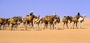
Timbuktu's wealth came from its location. It was at the southern end of a major trade route across the Sahara Desert. Today, the main goods transported are slabs of rock salt. These come from the Taoudenni mining center, 664 kilometers (413 miles) north of Timbuktu.
Until the mid-1900s, large salt caravans called azalai carried the salt. These caravans had thousands of camels. They took three weeks to travel one way. They brought food to the miners and returned with salt. Each camel carried four or five 30-kilogram (66-pound) salt slabs.
Desert nomads largely controlled this salt trade. Now, trucks usually transport the salt from Taoudenni. From Timbuktu, the salt is sent by boat to other towns in Mali.
Between the 12th and 14th centuries, Timbuktu's population grew a lot. Many people came for trade, safety, or to study. By 1300, the population reached 10,000. It kept growing to about 50,000 in the 1500s.
Farming in Timbuktu
There isn't enough rain in Timbuktu for farming without irrigation. So, crops are watered using water from the Niger River. The main crop grown is rice.
Traditionally, a type of rice called African floating rice was grown. This rice grows in areas near the river that flood every year. Seeds are planted at the start of the rainy season. When the floodwater arrives, the plants are already 30 to 40 centimeters (12 to 16 inches) tall.
The plants can grow up to 3 meters (10 feet) tall as the water rises. The rice is harvested by canoe in December. This method is risky and doesn't produce much rice. But it doesn't need much money to start. A good harvest depends on the rain and the flood height. Farmers can control the floodwater a little by building small mud walls.
Today, most rice is grown in three large irrigated areas south of the town. Water is pumped from the river using special screws. About 2,100 families work together in these areas. They grow rice on small plots. Almost all the rice they grow is eaten by their own families. Farmers are being encouraged to try new farming methods to get more rice.
Tourism in Timbuktu
Most tourists visit Timbuktu between November and February. This is when the weather is cooler. In the 1980s, there were a few small hotels for tourists. Over the years, more tourists came. By 2006, there were seven hotels and guest houses.
The town earned money from a tourist tax. It also benefited from selling handicrafts and hiring local guides.
Timbuktu in Old Stories
Stories about Timbuktu's amazing wealth made Europeans want to explore the west coast of Africa. Two famous accounts are by Leo Africanus and Shabeni.
Leo Africanus's Story
One of the most famous stories about Timbuktu was written by Leo Africanus. He was born in Granada in 1485. His family was among the many Muslims who had to leave Spain in 1492. They settled in Morocco, where he studied. He traveled with his uncle on trips across North Africa, and during these travels, he visited Timbuktu.
Later, pirates captured him. He was given to Pope Leo X, who freed him. The Pope asked him to write a detailed book about Africa in Italian. His book taught Europeans most of what they knew about Africa for centuries.
When Leo Africanus described Timbuktu, the Songhai Empire was at its strongest. He wrote:
The rich king of Tombuto has many gold plates and scepters. Some weigh 1300 pounds. ... He always has 3000 horsemen ... (and) many doctors, judges, priests, and other learned men. The king pays for them generously.
Leo Africanus also said there was plenty of local grain, cattle, milk, and butter. But there were no gardens or fruit trees around the city. He also mentioned how rare salt was in Timbuktu:
These descriptions made European explorers very interested. Africanus also described simpler things, like houses made of chalk with thatched roofs. But these details were mostly ignored.
Shabeni's Account
About 250 years after Leo Africanus, Timbuktu had many different rulers. In the late 1700s, a 14-year-old boy named Shabeni visited Timbuktu with his father. He was from Tetuan, Morocco.
Shabeni stayed in Timbuktu for three years. Then he moved to another city. Two years later, he returned to Timbuktu and lived there for seven more years. Even after its golden age, Timbuktu's population was twice as large as it is today.
When Shabeni was 27, he was a successful merchant. He traveled to Mecca and became a hajji (someone who has completed the pilgrimage). Later, he was captured by a ship sailing under a Russian flag. He was taken to Belgium but was eventually freed. He then ended up in England, where his story was written down.
Shabeni described the city's size in the late 1700s. He also said the area around Timbuktu used to have forests, unlike the dry desert it is today.
Arts and Culture in Timbuktu
Timbuktu is located where the Sahara trade routes meet the Niger River. It was founded in 1100 by the Tuareg people. This cultural center has important buildings, including three great mosques: Djinguere Ber, Sankore, and Sidi Yahya.
The Famous Mosques
The Djinguere Ber Mosque was built in 1328. It was supported by Mansa Musa, the rich ruler of the Mali Empire. This mosque showed how wealthy the city was during its golden age. Mansa Musa's famous trip to Mecca, where he gave away lots of gold, helped build the mosque. It also made Timbuktu known as a center of Islamic culture and learning. Over time, the Djinguere Ber mosque has been repaired and expanded. This shows how building styles and religious practices changed in the region.
The Sankore Mosque was built between 1325 and 1463. It was very important for learning and education in Timbuktu. As the city grew as an Islamic learning center, the Sankore Mosque became famous. Scholars and students from all over the Muslim world came here. Its libraries held thousands of manuscripts. These books covered topics from religion to astronomy. This made Timbuktu known for sharing ideas and different cultures.
The Sidi Yahya Mosque was founded in 1440. It was built by a respected religious leader, Sheikh al-Mukhtar Hamallah. This mosque was important for both religious and spiritual reasons. A local story says the mosque was waiting for a saint named Sidi Yahya al-Tadlissi. His presence would make the place holy. When Sidi Yahya arrived 40 years later, the mosque became a place for prayer and pilgrimages. The mosque has been renovated many times, showing the changes in Timbuktu's religious and cultural life.
Cultural Events
The most famous cultural event is the Festival au Désert. In 1996, the Tuareg rebellion ended. To celebrate peace, 3,000 weapons were burned in a ceremony. A monument was built to remember this event. The Festival au Désert was held every January in the desert, 75 kilometers (47 miles) from the city, until 2010.
The week-long Mawloud festival is held every January. It celebrates the birthday of the Prophet Muhammad. The city's most treasured manuscripts are read publicly during this celebration. It was originally a festival from Persia and came to Timbuktu around 1600. It is the "most joyful occasion" in Timbuktu. It combines Sufi Islamic traditions with celebrating Timbuktu's rich literary history. It is a time of "feasting, singing, and dancing." It ends with thousands of people gathering in front of the Sankore Mosque. There, some of the city's most valued manuscripts are read aloud.
Since 2015, Timbuktu has also hosted the Living Together festival every winter.
World Heritage Site Status
In December 1988, parts of Timbuktu's historic center were added to the World Heritage list. This means they are very important cultural sites for the world. The selection was based on three reasons:
- Reason 1: Timbuktu's holy places were key to spreading Islam in Africa.
- Reason 2: Timbuktu's mosques show a time of great culture and learning during the Songhay Empire.
- Reason 3: The mosques were built using traditional methods. Most of them are still original.
Earlier, in 1979, the whole town of Timbuktu was nominated. But it was not accepted because the boundaries were not clear. Almost ten years later, three mosques and 16 tombs or cemeteries from the Old Town were chosen. With this, came the need to protect the buildings. New construction near the sites was limited. Also, steps were taken to stop sand from covering the buildings.
Soon after, the monuments were put on the List of World Heritage in Danger. This was done by the Malian government and the selection committee. The first time on the Danger List was from 1990 to 2005. During this time, restoration work was done. An inventory of the sites was also made. Because of this, it was removed from the Danger List. In 2008, the World Heritage Committee watched the protected area more closely. This was because it was unclear how new building plans might affect the sites. Special attention was given to building a cultural center.
In June 2009, UNESCO decided to stop watching so closely. They felt enough progress had been made. However, after an armed group took over Timbuktu in 2012, it was put back on the List of World Heritage in Danger.
Many local people are now working to preserve these sites. They manage and restore the historic mosques in the city.
Education and Learning
Timbuktu: A Center of Knowledge
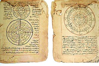
Timbuktu was a global center for Islamic learning from the 13th to the 17th century. This was especially true under the Mali Empire and the rule of Askia Mohammad I. The Malian government and other groups are working to find and restore Timbuktu's old scholarly writings. These are known as the Timbuktu manuscripts.
Timbuktu's economy grew quickly in the 13th and 14th centuries. This attracted many scholars from nearby Walata. This led to the city's golden age in the 15th and 16th centuries. During this time, there was much learning in religion, arts, and sciences. For the people of Timbuktu, reading and books showed wealth, power, and blessings. Getting books became very important for scholars.
There was a busy trade in books between Timbuktu and other parts of the Islamic world. Emperor Askia Mohammed strongly supported this. This led to thousands of manuscripts being written.
Knowledge was shared in a way similar to early European universities. Teaching happened in informal places called madrasahs. Today, these are known as the University of Timbuktu. Three madrasahs taught 25,000 students: Djinguereber, Sidi Yahya, and Sankore.
These schools were mainly religious. This was different from modern European universities, which teach more general subjects. But they were similar to medieval European universities. In West Africa, education was supported by families. The Aqit and Bunu al-Qadi al-Hajj families were very important in Timbuktu. These families also provided rooms for students in their homes.
Islamic law and its teaching came to Timbuktu from North Africa. But West African scholars also developed their own ideas. Ahmad Baba al Massufi is seen as the city's greatest scholar.
Timbuktu helped spread scholars and knowledge. Because it relied on trade, scholars moved a lot between the city and its many trade partners. However, in 1468–1469, many scholars left for Walata. This happened when Sunni Ali's Songhay Empire took over Timbuktu. Then, during the Moroccan invasion in 1591, scholars had to flee again. Otherwise, they faced being jailed or killed.
This education system lasted until the late 1800s. In the 1700s, traveling Quranic schools started. Scholars would travel with their students, begging for food part of the day.
Islamic education faced challenges after the French took over. Droughts in the 1970s and 1980s also caused problems. The civil war in Mali in the early 1990s also affected it.
Timbuktu's Manuscripts and Libraries
Hundreds of thousands of manuscripts were collected in Timbuktu over centuries. Some were written in the city itself. Others, including special copies of the Quran for rich families, were brought in through the busy book trade.
Many of these manuscripts survived the city's decline. They were hidden in cellars, buried, or kept safe in mosque walls by their owners. Now, they form collections in several Timbuktu libraries. In 2003, there were up to 700,000 manuscripts.
In January 2013, it was reported that rebel forces destroyed many manuscripts. However, most of them were safely hidden away by the librarian Abdel Kader Haidara and local people. About 350,000 manuscripts were moved to safety. In 2022, 300,000 of them were still in Bamako.
These libraries are the largest among an estimated 60 private or public libraries in Timbuktu today. Some are just a few books on a shelf. The manuscripts are at risk of damage and theft. They also face long-term damage from the climate, even though Timbuktu is dry. Two projects have worked to preserve them.
During the occupation by extremists, citizens worked to save these important writings. Local residents said they had protected 300,000 manuscripts for generations. Many are still kept by residents. They are hesitant to give them to the government-run Ahmed Baba Institute. This modern building was built in 2009. It only holds 10% of the manuscripts.
It was later confirmed that most manuscripts, about 50,000, are in 32 family libraries. These are still protected. Also, 200,000 other manuscripts were moved to safety by one person, Abdel Kader Haidara. He bought metal boxes to store up to 300 manuscripts each. Nearly 2,500 of these boxes were given to safe houses across the city.
Languages Spoken in Timbuktu
The main language in Mali is Bambara. But today, most people in Timbuktu speak Koyra Chiini. This is a Songhay language and is the common language used for communication. Before the Tuareg rebellion (1990–1994), Koyra Chiini was spoken by 80% of the people. Hassaniya Arabic and Tamashek were each spoken by 10%.
Tamashek was spoken by both Ikelan and ethnic Tuaregs. Its use decreased after many Tuaregs were expelled following the rebellion. This made Koyra Chiini even more dominant.
Arabic came with Islam in the 11th century. It has mainly been the language of scholars and religion. It's like how Latin was used in Western Christianity.
Bambara is spoken by the largest ethnic group in Mali. But it is mostly used in the south of the country. As Timbuktu gets better roads to southern cities, the use of Bambara in the city was increasing.
Getting Around Timbuktu
Mali has very few railroads. The only one is the Dakar-Niger Railway up to Koulikoro. So, you can reach Timbuktu by road, boat, or plane. Flights started in 1961.
When the Niger River has high water levels (from August to December), passenger ferries operate. These ferries travel between Koulikoro and Gao. Large motorized boats called pinasses also travel up and down the river. You can charter them or use public ones.
Both ferries and pinasses arrive at Korioumé. This is Timbuktu's port. It is connected to the city center by an 18-kilometer (11-mile) paved road through Kabara. In 2007, a project cleared the canal connecting Kabara to the Niger River. Now, ferries and pinasses can reach Kabara when the river is fully flooded.
Timbuktu is not well connected to Mali's road network. There are only dirt roads to nearby towns. The roads south of the river are also not very good. However, a new paved road is being built between Niono and Timbuktu. It runs north of the Inland Niger Delta.
The new 81-kilometer (50-mile) section between Niono and Goma Coura is finished. The 484-kilometer (301-mile) section between Goma Coura and Timbuktu is being funded by the European Development Fund.
Timbuktu Airport used to have flights to and from Bamako, Gao, and Mopti. But the airline stopped operating in 2014. The airport's runway is 2,110 meters (6,923 feet) long. It is lit and paved.
Currently (July 2023), Sky Mali flies to and from Bamako using Boeing 737 planes.
Famous People from Timbuktu
- Ali Farka Toure (1939–2006), a famous musician known for desert blues music.
- Ahmad Baba al-Timbukti (1556–1627), a writer, scholar, and political activist.
- Abdul Rahman Ibrahima Sori (1762–1829), a prince who was captured and sold into slavery in the United States.
- Mahamane Alassane Haidara (1910–1981), a politician elected to the French Senate.
- Souheil Ben-Barka (born 1942), a Moroccan film director and producer.
- Cissé Mariam Kaïdama Sidibé (1948–2021), a Malian politician and the first female prime minister of Mali.
- Alphadi (born 1957), a famous fashion designer from Niger, known as the "Magician of the Desert."
Sister Cities
Timbuktu is twinned with these cities:
 Chemnitz, Germany
 Hay-on-Wye, Wales (United Kingdom)
 Kairouan, Tunisia
 Marrakesh, Morocco
 Saintes, France
 Tempe, United States
Images for kids
See also
 In Spanish: Tombuctú para niños
 | Calvin Brent |
 | Walter T. Bailey |
 | Martha Cassell Thompson |
 | Alberta Jeannette Cassell |


