
Niamey facts for kids
Quick facts for kids
Niamey
|
||
|---|---|---|
| Names transcription(s) | ||
| • Zarma | ٽَمَيْ | |
| • Hausa | یَمَیْ یَمَیْ |
|
| • Tawallammat | ⵏⵉⵎⵢ نِيامِيْ |
|
  (3).jpg)  .jpg) ,_panorama.jpg) Niamey from grand mosque, Trois Sœurs, Place du Temple, Zoo du Musée national de Niamey, Kountché Stadium, Dunes
|
||
|
||

Capital of Niger
|
||

Niamey
Location in Niger

Niamey
Location in Africa
|
||
| Country | ||
| Region | Niamey Urban Community | |
| Communes Urbaines | 5 Communes | |
| Districts | 44 Districts | |
| Quartiers | 99 Quarters | |
| Government | ||
| • Type | Appointed district government, elected city council, elected commune and quarter councils | |
| Area | ||
| • Total | 239.30 km2 (92.39 sq mi) | |
| Elevation | 207 m (679 ft) | |
| Population
(2012)
|
||
| • Total | 1,026,848 | |
| • Estimate
(October 1, 2020)
|
1,334,984 | |
| • Density | 4,291.05/km2 (11,113.77/sq mi) | |
| Niamey Urban Community | ||
| Time zone | UTC+1 (WAT) | |
| Area code(s) | 20 | |
Niamey is the capital and largest city of Niger. It sits on the Niger River, mostly on its east bank. In 2012, Niamey had a population of over 1 million people. The city is known for growing pearl millet. It also has factories that make bricks, ceramic goods, cement, and woven items.
Contents
History of Niamey
Niamey likely started in the 1700s as a group of small villages. These included Gaweye, Kalley, Maourey, Zongo, and Foulani Koira. The city was not very important until the French made it a colonial center in the late 1890s.

In 1905, Niamey became the capital of the new Military Territory of Niger. At that time, about 1,800 people lived there. However, the capital moved to Zinder in 1912. Zinder was closer to the Nigerian border and far from French ports. So, the French moved the capital back to Niamey in 1926. By then, the city had about 3,000 residents.
Several bad droughts caused many people to move from the countryside to Niamey. This made the city grow a lot. By 1945, about 8,000 people lived there. Before 1926-27, the border between French Upper Volta and Niger ran along the Niger River. This meant Niamey was right on the border.
.jpg)
When Niger became independent in 1960, Niamey's population had grown to about 30,000. From 1970 to 1988, Niger's economy grew quickly. This was thanks to money from uranium mines. As a result, Niamey's population jumped from 108,000 to nearly 400,000. The city also grew in size, taking in nearby villages. More droughts also caused many people from rural Niger to move to the city.
In 1992, Niamey and its surrounding area became a special capital district. This district was much smaller and was located within the new Tillabéri Region. In 1999, there was a political change in Niger. By 2000, some estimates said the population reached 700,000. In 2011, government reports suggested the city's population was over 1.5 million. This growth is due to people moving for work and during droughts. Also, many young people live in the city because of a high birth rate. Recently, in April 2024, people in Niamey held protests about international military agreements.
Geography and Climate
Niamey's Location

The Niamey area is located between two landforms. These are the Liptako hills and the edge of the Iullemmeden basin. The city covers over 250 square kilometers. It sits on two plateaus that are about 218 meters high. The Niger River cuts through the city.
In Niamey, the river makes several wide bends. The city grew mostly on the east side of the river. This is the "left bank" as the river flows from west to east, then turns south. There are also several marshy islands in the river near Niamey.
Most of the people and buildings are on the eastern bank. The city center has wide roads connecting roundabouts. Two bridges, the Kennedy Bridge and the Friendship Bridge, connect the two sides of the river. The western bank has mostly homes and Abdou Moumouni University.
Niamey's Weather
Niamey has a hot and semi-arid climate. This means it is very dry. The city gets between 500 and 750 millimeters of rain each year. Most of this rain falls during the rainy season, from June to early September. There is almost no rain from October to April.
Niamey is very hot all year round. It is one of the hottest major cities in the world. Average high temperatures reach 38°C for four months of the year. They never drop below 32°C. During the dry season, from November to February, nights are usually cool. Nighttime lows are between 14°C and 18°C.
| Climate data for Niamey (1991–2020, extremes 1961–present) | |||||||||||||
|---|---|---|---|---|---|---|---|---|---|---|---|---|---|
| Month | Jan | Feb | Mar | Apr | May | Jun | Jul | Aug | Sep | Oct | Nov | Dec | Year |
| Record high °C (°F) | 40.7 (105.3) |
44.0 (111.2) |
45.0 (113.0) |
46.1 (115.0) |
47.0 (116.6) |
44.4 (111.9) |
41.0 (105.8) |
39.6 (103.3) |
41.8 (107.2) |
41.6 (106.9) |
41.8 (107.2) |
40.0 (104.0) |
47.0 (116.6) |
| Mean daily maximum °C (°F) | 32.4 (90.3) |
35.8 (96.4) |
39.5 (103.1) |
41.6 (106.9) |
40.7 (105.3) |
37.9 (100.2) |
34.6 (94.3) |
32.8 (91.0) |
34.9 (94.8) |
38.0 (100.4) |
37.1 (98.8) |
33.6 (92.5) |
36.6 (97.9) |
| Daily mean °C (°F) | 24.6 (76.3) |
27.8 (82.0) |
31.9 (89.4) |
34.7 (94.5) |
34.5 (94.1) |
32.2 (90.0) |
29.5 (85.1) |
28.1 (82.6) |
29.6 (85.3) |
31.5 (88.7) |
29.0 (84.2) |
25.5 (77.9) |
29.9 (85.8) |
| Mean daily minimum °C (°F) | 17.2 (63.0) |
20.1 (68.2) |
24.3 (75.7) |
27.9 (82.2) |
28.8 (83.8) |
26.8 (80.2) |
25.0 (77.0) |
24.1 (75.4) |
24.8 (76.6) |
25.1 (77.2) |
21.2 (70.2) |
17.9 (64.2) |
23.6 (74.5) |
| Record low °C (°F) | 8.3 (46.9) |
10.4 (50.7) |
16.0 (60.8) |
19.9 (67.8) |
20.2 (68.4) |
19.8 (67.6) |
19.4 (66.9) |
19.4 (66.9) |
19.5 (67.1) |
18.0 (64.4) |
13.4 (56.1) |
11.6 (52.9) |
8.3 (46.9) |
| Average precipitation mm (inches) | 0.0 (0.0) |
0.3 (0.01) |
0.2 (0.01) |
9.8 (0.39) |
25.3 (1.00) |
78.6 (3.09) |
145.6 (5.73) |
192.6 (7.58) |
85.1 (3.35) |
16.7 (0.66) |
0.0 (0.0) |
0.0 (0.0) |
554.2 (21.82) |
| Average precipitation days (≥ 1.0 mm) | 0.0 | 0.0 | 0.1 | 1.0 | 2.7 | 6.0 | 9.7 | 12.1 | 6.8 | 1.7 | 0.0 | 0.0 | 40.1 |
| Average relative humidity (%) | 22 | 17 | 18 | 27 | 42 | 55 | 67 | 74 | 73 | 53 | 34 | 27 | 42 |
| Mean monthly sunshine hours | 285.0 | 259.1 | 263.3 | 256.8 | 266.8 | 247.4 | 245.1 | 226.2 | 250.1 | 286.1 | 293.8 | 299.4 | 3,179.1 |
| Source 1: NOAA, Météo Climat | |||||||||||||
| Source 2: Deutscher Wetterdienst (humidity 1961-1990) | |||||||||||||
Population and Culture
Niamey's Growing Population

| Historical population | ||
|---|---|---|
| Year | Pop. | ±% |
| 1901 | 600 | — |
| 1930 | 3,000 | +400.0% |
| 1950 | 24,370 | +712.3% |
| 1960 | 57,548 | +136.1% |
| 1970 | 129,209 | +124.5% |
| 1977 | 242,973 | +88.0% |
| 1988 | 397,437 | +63.6% |
| 2001 | 725,030 | +82.4% |
| 2012 | 1,026,848 | +41.6% |
| 2020 | 1,324,700 | +29.0% |
Niamey's population has grown very quickly since Niger became independent. Droughts and economic problems in the 1970s and 1980s caused many people to move to the city. The population grew from about 3,000 in 1930 to 250,000 in 1980. By 2000, it was around 800,000.
In the past, the government had rules about who could live in the city. They would send people without permits back to their villages. But as freedoms grew in the late 1980s and 1990s, more people moved to Niamey. This included people affected by the Tuareg Rebellion and famines. This led to large informal settlements on the edge of the city.
Culture and Architecture in Niamey
.jpg)
A popular place in Niamey is the Niger National Museum. It has a zoo, a museum about local buildings, and a craft center. You can see dinosaur skeletons and learn about the Tree of Ténéré there. Other interesting places include cultural centers from America, France, and Niger.
There are also seven main market centers, including the large Niamey Grand Market. You can find a traditional wrestling arena and a horse racing track. Much of the colorful pottery sold in Niamey is made by hand in the nearby village of Boubon. In December 2005, Niamey hosted the Jeux de la Francophonie, a big event for French-speaking countries.
Places of Worship
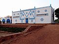
Niger is mostly a Muslim country. So, mosques are the most common places to worship. The Grande Mosquée is the largest mosque in the city. There are also several Christian churches. These include Our Lady of Perpetual Help Cathedral and the Cathedral de Maourey.
How Niamey is Governed
City Administration
Niamey is a special capital district in Niger. It is surrounded by the Tillabéri Region. The city itself is managed by the Niamey Urban Community (CUN). This community includes five urban areas called "Communes Urbaines." These are divided into 44 "Districts" and 99 "Quartiers" (quarters). This includes towns that used to be separate.
.jpg)
The Niamey Urban Community has its own government and a Governor chosen by national leaders. Since 2000, Niger has been giving more power to local governments. In 2010, a new system was set up for Niamey. It created an elected City Council for the city. Forty-five council members are chosen by the people. They then elect the Mayor of Niamey. In July 2011, Oumarou Dogari Moumouni became the first Mayor under this new system. The City Council and Mayor have some power, but the CUN Governor still has a lot of control.
Niamey also has a third level of government through the Commune system. Each Commune elects its own council. In other cities, these Communes act like independent cities. But in Niamey and other big cities, they work together to manage the larger urban area.
Under this system, the CUN has five urban communes. These are further divided into 99 quarters, each with elected boards.
Communes and Quarters of Niamey
The Niamey Urban Community includes 99 quarters, divided among five communes:
| Commune | Quarters | Map | City map with the 5 communes |
|---|---|---|---|
| Niamey I |
20 Quarters
|
|
.png) |
| Niamey II |
17 Quarters
|
|
|
| Niamey III |
17 Quarters
|
|
|
| Niamey IV |
17 Quarters
|
|
|
| Niamey V |
28 Quarters
|
|
The CUN also includes land from several towns and villages that Niamey has grown to cover. These include Soudouré, Lamordé, Gamkallé, Yantala, and Gaweye. The CUN covers about 239.30 square kilometers. Until 1998, all of greater Niamey was part of the Tillabéri Region. The CUN is still surrounded by the Tillabéri Region.
Transportation in Niamey

Niamey is served by the Diori Hamani International Airport. This airport is located 12 kilometers southeast of the city. The city is also crossed by the RN1 highway. The Niamey railway station opened in April 2014. It was the first railway station built in Niger. People also use boats to travel on the Niger River.
Education in Niamey
Niamey is home to many important schools and institutes. These include the National School of Administration and Abdou Moumouni University. The Higher Institute of Mining, Industry and Geology is on the right bank of the river. There are also many research institutes, like the Centre Numérique de Niamey and ICRISAT. Niamey also hosts the African Centre of Meteorological Application for Development.
Notable People from Niamey
- Bombino (musician)
- Lucien Bouchardeau (referee)
- Samira Sabou (journalist)
Images for kids
-
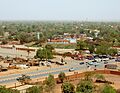
Niamey from the Grand Mosque
-
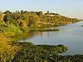
Niger River in Niamey
-
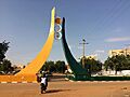
Place du Temple
-
Zoo at the National Museum of Niamey
-
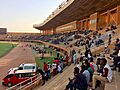
Kountché Stadium
-
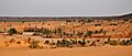
Dunes near Niamey
-
Logo of the City of Niamey
-
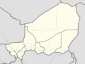
Map showing Niamey in Niger
See also
 In Spanish: Niamey para niños
