
Aral Sea facts for kids
Quick facts for kids Aral Sea |
|
|---|---|

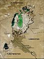
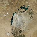
The Aral Sea in 1989 (left) and 2008 (right)
|
|
| Location | Kazakhstan - Uzbekistan, Central Asia |
| Coordinates | 45°N 60°E / 45°N 60°E |
| Type | endorheic, natural lake, reservoir (North) |
| Primary inflows | North: Syr Darya South: groundwater only (previously the Amu Darya) |
| Catchment area | 1,549,000 km2 (598,100 sq mi) |
| Basin countries | Afghanistan, Kazakhstan, Tajikistan, Turkmenistan, Uzbekistan |
| Surface area | 17,160 km2 (6,626 sq mi) (2004, four lakes) 28,687 km2 (11,076 sq mi) (1998, two lakes) 68,000 km2 (26,300 sq mi) (1960, one lake) North: 3,300 km2 (1,270 sq mi) (2008) South: 3,500 km2 (1,350 sq mi) (2005) |
| Average depth | North: 8.7 m (29 ft) (2007) South: 14–15 m (46–49 ft)(2005) |
| Max. depth | North: 42 m (138 ft) (2008) 18 m (59 ft) (2007) 30 m (98 ft) (2003) South: 37–40 m (121–131 ft) (2005) 102 m (335 ft) (1989) |
| Water volume | North: 27 km3 (6 cu mi) (2007) |
| Surface elevation | North: 42 m (138 ft) (2007) South: 29 m (95 ft) (2007) 53.4 m (175 ft) (1960) |
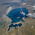
The Aral Sea (Kazakh: Арал Теңізі, Uzbek: Orol dengizi, Russian: Аральскοе мοре) is a large lake in Central Asia. It is located between Kazakhstan in the north and Karakalpakstan, a region of Uzbekistan, in the south.
For many years, the Aral Sea was one of the world's largest lakes. However, since the 1960s, it has shrunk dramatically. Today, about 90% of its water has disappeared. This happened because the rivers that fed the sea, the Amu Darya and the Syr Darya, were used to water crops.
The remaining parts of the Aral Sea are very polluted. This pollution comes from weapons testing, factories, and fertilizer runoff. These issues happened both before and after the Soviet Union broke apart.
Contents
Why Did the Aral Sea Shrink?
The main reason the Aral Sea shrank was due to irrigation. Starting in the 1960s, the Soviet Union began using the water from the Amu Darya and Syr Darya rivers. This water was diverted to grow cotton in the dry desert areas.
Cotton needs a lot of water to grow. As more and more water was taken from the rivers, less and less reached the Aral Sea. Over time, the sea began to dry up, splitting into smaller, separate lakes.
Efforts to Save the Sea
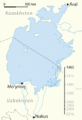
There is a big project to try and save at least the northern part of the Aral Sea. In the 1990s, a dam was built. This dam was meant to stop water from flowing out of the northern part.
The climate improved for a while, and water levels in the North Aral Sea rose. However, that first dam broke. A new dam was built in 2005 with help from other countries. This new dam has helped the North Aral Sea recover some of its size.
The Island of Rebirth
There was an island in the Aral Sea called the Island of Rebirth. This island was used for testing dangerous germs until 1993. These tests left the island with harmful substances.
Since 2001, the Island of Rebirth is no longer an island. It has become a peninsula because the sea around it dried up. This means it is now connected to the mainland.
-
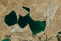
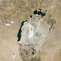
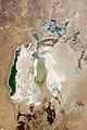
2004 photo of the Aral Sea (The black lines are where it was in 1850)
-
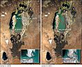
Rebirth island (an island in the Aral Sea) joins the mainland (2000/2001)
-
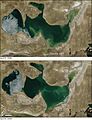
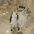
North Aral Sea, comparison April 2005/2006 (showing the sea has grown)
-
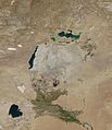
Shrinking of the Aral Sea 1960-2014


Images for kids
-
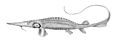
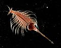
The Syr Darya sturgeon (Pseudoscaphirhynchus fedtschenkoi) was a primitive species of fish possibly driven to extinction by the shrinkage of the Aral Sea.
-
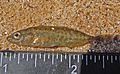
The Ukrainian stickleback (Pungitius platygaster) was the only native species of the Aral Sea to survive its reduction and salinization.
-
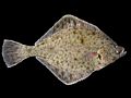
The European flounder (Platichthys flesus) was a saltwater fish introduced to the Aral Sea.
-

The black carp (Mylopharyngodon piceus) was a freshwater fish introduced to the Aral Sea.
-
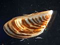
Zebra mussel (Dreissena polymorpha), a former dominant member of the sea's benthic fauna, and has since returned to the North Aral Sea.
-
Parthenogenic brine shrimp (Artemia parthenogenetica), the dominant crustacean of the South Aral Sea and its fragments.
-
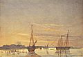
First Russian boats on the Aral Sea, watercolor by Taras Shevchenko, 1848
-
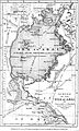
1853 map of the Aral Sea
-
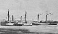
Ships of Imperial Russian Navy's Aral Flotilla in the 1850s
-
Map including the Aral Sea and surrounding region (DMA, 1979)
-
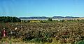
Cotton picking near Kyzyl-Kala, Karakalpakstan.
-
Timeline of shrinking
-
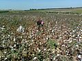
Cotton picking in Uzbekistan. Cotton is one of the biggest water consuming plants.
-
Comparison of the North Aral Sea before (below) and after (above) the construction of Dike Kokaral completed in 2005.
-
Comparison of the North Aral Sea in 2000 and 2011.
-
"Rebirth" Island joins the mainland in mid-2001.
-
Aral Sea from space (north at bottom), August 1985
-
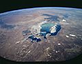
Aral Sea from space (north at bottom), August 1997
-
Aral Sea from space (north at top), August 2009
-
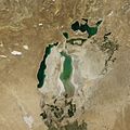
Aral Sea in August 2010, with part of the eastern basin reflooded from heavy snowmelt.
-
Aral Sea completely loses its eastern lobe in August 2014
-
Aral Sea from space, August 2017. Part of the eastern basin was reflooded from heavy snowmelt in 2015.
-
April 2018
-
Aral Sea once again completely loses its eastern lobe in August 2021
.jpg)

.jpg)
.jpg)


-03.jpg)


_NASA_STS085-503-119.jpg)


.jpg)

See also
 In Spanish: Mar de Aral para niños
