
Amu Darya facts for kids
Quick facts for kids Amu Darya |
|
| Oxus, Jayhoun, də Āmu Sind, Vaksu, Amu River | |
 Amu Darya Delta from space
|
|
| Name origin: Named for city of Āmul (now Turkmenabat) | |
| Countries | Tajikistan, Afghanistan, Turkmenistan, Uzbekistan |
|---|---|
| Region | Central Asia |
| Tributaries | |
| - left | Panj River |
| - right | Vakhsh River, Surkhan Darya, Sherabad River, Zeravshan River |
| Length | 2,400 km (1,491 mi) |
| Basin | 534,739 km² (206,464 sq mi) |
| Discharge | |
| - average | 2,525 m³/s (89,170 cu ft/s) |
The Amu Darya is a very important river in Central Asia. It is also known as the Amu or Amo River. This river starts where the Vakhsh and Panj rivers meet. This meeting point is in the Tigrovaya Balka Nature Reserve, right on the border between Tajikistan and Afghanistan. From there, the Amu Darya flows northwest. It eventually reaches the southern parts of the Aral Sea.
Long ago, in ancient history, people thought of this river as a border. It separated a region called Greater Iran from another area known as Turan.
Contents
What is the Amu Darya Called?

Over time, the Amu Darya has had many different names. In ancient times, people called it Vaksu. This name was used by the Indo-Aryan people. In ancient Afghanistan, it was also known as Gozan.
When the Greeks and Romans wrote about it, they had their own names. The Greeks called it Oxos, and the Romans used the name Ōxus.
Where Does the Amu Darya's Water Come From?
Most of the water in the Amu Darya comes from glaciers. These glaciers are found high up in the Pamir Mountains and the Tian Shan mountain range. The mountains act like giant sponges. They collect moisture from the air that would otherwise just float away.
Without these mountain water sources, the Amu Darya would be dry. This is because it hardly ever rains in the lowlands where most of the river flows. In the steppe areas, the yearly rainfall is only about 300 millimeters (12 inches).
How Has the River Changed Over Time?
Scientists believe the Amu Darya's path has changed a lot. This has happened many times over thousands of years. For long periods, the river used to flow into both the Aral Sea and the Caspian Sea. One of these periods was from the 13th century to the late 16th century.
People started living along the lower parts of the Amu Darya around the 5th century A.D. They built farms, towns, and cities. These settlements created a busy chain of life along the river.
Who Explored the Amu Darya?
The first British explorer to reach this region was a naval officer. His name was John Wood. In 1839, he went on a trip to find where the river started. He found a lake that is now called Lake Zorkul. He named it Lake Victoria and thought he had found the source of the river.
Later, a French explorer named Thibaut Viné gathered much more information. He explored the area during five trips between 1856 and 1862.
The Amu Darya in Modern Times
In the 20th century, the Soviet Union became the main power in the region. After the Soviet Union broke apart in the 1990s, Central Asia split into many smaller countries. Many of these countries are in or near the Amu Darya river basin.
In the 1960s and 1970s, the Soviets started using the Amu Darya and Syr Darya rivers. They used the water to grow huge fields of cotton in the Central Asian plain. This irrigation changed the flow of the rivers.
Images for kids
-
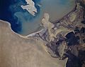
Amu Darya delta seen from space
-
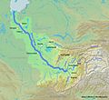
Map showing the Amu Darya watershed
-
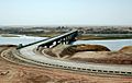
The Afghanistan-Tajikistan bridge over the Darya
-
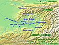
A map of ancient Bactria
-
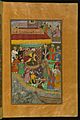
Bāqī Chaghānyānī showing respect to Babur by the Amu Darya river in 1504 AD
-
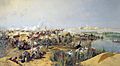
Russian soldiers crossing the Amu Darya, around 1873


.jpg)

See also
 In Spanish: Amu Daria para niños
