
Greater Iran facts for kids


.svg)
.svg)
.svg)
.svg)
Greater Iran (Persian: ایران بزرگ, romanized: Irān-e Bozorg) refers to a large area in Western Asia, Central Asia, South Asia, and Transcaucasia. In these regions, Iranian culture and Iranian languages have been very important. Historically, many Iranian empires ruled these lands. They shared a lot of Persian culture through close contact. Sometimes, many Iranian peoples settled there and kept their traditions alive. This area is generally around the Iranian plateau. Some experts call it the Iranian Cultural Continent.
The term "Greater Iran" includes the modern country of Iran and all the lands ruled by Iranian peoples throughout history. This includes parts of Mesopotamia, eastern Anatolia, the Caucasus, and Central Asia. The idea of Greater Iran started with the Achaemenid Persian Empire in the region of Persis (modern-day Fars Province, Iran). It is closely linked to the history of Iran.
In recent centuries, Iran lost many lands it had gained under the Safavid and Qajar rulers. For example, most of Iraq was lost to the Ottomans through treaties in 1555 and 1639. Western Afghanistan was lost to the British in 1857 and 1905. Also, Caucasus territories were lost to the Russians during wars between the 17th and 19th centuries. The Treaty of Gulistan in 1813 made Iran give up Dagestan, Georgia, and most of Azerbaijan to Russia. The Treaty of Turkmenchay in 1828 ended Iranian rule over its Caucasian provinces. Iran had to give up modern-day Armenia, the rest of Azerbaijan, and Iğdır (in eastern Turkey). The Aras River became the new border.
In 1935, the name Iran became the official international name of Persia. This was decided by Reza Shah Pahlavi. However, in 1959, the government of Mohammad Reza Pahlavi said that both "Persia" and "Iran" could be used.
Contents
What Does "Iran" Mean?
The name "Iran" means "land of the Aryans." It comes from an old word, aryānām, which meant "of the Aryans." This word first appeared in the Avesta, an ancient text. The Avesta was written in Avestan, an old Iranian language spoken in parts of what are now Afghanistan, Uzbekistan, Turkmenistan, and Tajikistan. The term Airyana Vaēǰah in the Avesta refers to the homeland of Zoroaster and Zoroastrianism.
For a long time, until the 3rd century CE, "Irān" referred to a group of people who shared a language and religion. It wasn't a political idea yet. The idea of an "Iranian" empire or kingdom as a political state started with the Sasanian dynasty. This happened because the new rulers and the Zoroastrian religious leaders worked together. This led to the idea of Ērān-šahr, meaning "Kingdom of the Iranians."
Defining Greater Iran
Richard Nelson Frye describes Greater Iran as including "much of the Caucasus, Iraq, Afghanistan, Pakistan and Central Asia." He says its cultural influence reached China and western India. According to Frye, "Iran means all lands and peoples where Iranian languages were and are spoken, and where in the past, multi-faceted Iranian cultures existed."
Richard Foltz notes that many people think all Iranian peoples in "Greater Iran" were Zoroastrians before Islam. However, he says this view is likely too strong. While Iranian peoples shared some gods and myths, they worshipped different deities depending on the time and place. For example, Mitra (god of agreements) and Anahita (goddess of waters) were often worshipped.
To the Ancient Greeks, Greater Iran stretched to the Indus River in Pakistan.
Historians like J. P. Mallory and Douglas Q. Adams say that during the Achaemenid era, people in western Greater Iran spoke Southwestern Iranian languages. Those in the east spoke Eastern Iranian languages, similar to Avestan.
After the Mongol Empire broke up, the Ilkhanids ruled Greater Iran. Uljaytu was the ruler of this vast area from 1304 to 1317 AD.
Traditional sources, like the historian Mir Khwand, say that Iranshahr (Greater Iran) stretched from the Euphrates to the Oxus rivers.
Historically, people in these regions did not define themselves by ethnicity. Richard Nelson Frye said:
Many times I have emphasized that the present peoples of Central Asia, whether Iranian or Turkic speaking, have one culture, one religion, one set of social values and traditions with only language separating them.
— Richard Nelson Frye
Only in modern times, with outside influences, did ethnicity become a dividing factor. "Greater Iran" was more of a cultural area than a single political state.
The medieval geographer Hamdallah Mustawfi wrote in his book Nuzhat al-Qolub: چند شهر است اندر ایران مرتفع تر از همه
Some cities in Iran are above the rest,
بهتر و سازنده تر از خوشی آب و هوا
better and more productive due to good weather,
گنجه پر گنج در اران صفاهان در عراق< Ganja full of treasure in Arran, and Esfahān in Iraq,
در خراسان مرو و طوس در روم باشد اقسرا
Merv and Tus in Khorasan, and Konya (Aqsara) in Rome (Anatolia).
The Cambridge History of Iran describes "Greater Iran" as a "historical and cultural" area. It includes "areas of Iran, parts of Afghanistan, and Chinese and Soviet Central Asia."
Historical Background
Greater Iran is also called Iranzamin (ایرانزمین), which means "Iranland" or "The Land of Iran." In ancient myths, Iranzamin was different from Turanzamin, the Land of Turan, located in Central Asia.
Before Islam, Iranians divided the lands they ruled into Iran and Aniran. Iran meant all regions where ancient Iranian peoples lived. This area was much larger in the past. This idea of "Iran" as a territory was the start of Greater Iran. Even though borders changed, Iranian languages and culture remained strong in many parts of Greater Iran.
For example, the Persian language (called Farsi in Persian) was the main language for literature and communication in Central Asia and the Caucasus before Russia took over. Central Asia is where the modern Persian language began. The British government also noted that Persian was used in Iraqi Kurdistan before British rule (1918–1932).
As Imperial Russia moved south and signed treaties like Turkmenchay and Gulistan, many Central Asian rulers lost hope for Persian support against the Russian armies. The Russians took over areas like the Aral coast in 1849, Tashkent in 1864, Bukhara in 1867, Samarkand in 1868, and Khiva and Amudarya in 1873.
Patrick Clawson of the Washington Institute for Near East Policy explains:
Many Iranians consider their natural sphere of influence to extend beyond Iran's present borders. After all, Iran was once much larger. ... In the 19th century, the Russian Empire wrested from Tehran's control what is today Armenia, Republic of Azerbaijan, and part of Georgia. ... The Shah lost much of his claim to western Afghanistan following the Anglo-Iranian war of 1856-1857. ... In centuries past, Iranian rule once stretched westward into modern Iraq and beyond. When the western world complains of Iranian interference beyond its borders, the Iranian government often convinced itself that it is merely exerting its influence in lands that were once its own. Simultaneously, Iran's losses at the hands of outside powers have contributed to a sense of grievance that continues to the present day.
— Patrick Clawson
He also states:
Iran today is just a rump of what it once was. At its height, Iranian rulers controlled Iraq, Afghanistan, Western Pakistan, much of Central Asia, and the Caucasus. Many Iranians today consider these areas part of a greater Iranian sphere of influence.
— Patrick Clawson
Regions of Greater Iran
In the 8th century, the Abbassids conquered Iran, ruling from Baghdad. Iran was then divided into Persian Iraq (western part) and Khorasan (eastern part). The cities of Gurgan and Damaghan were generally the dividing line. Later empires like the Ghaznavids, Seljuqs, and Timurids also used these divisions. Transoxiana and Chorasmia were mostly part of the Khorasan region.
Middle East
Bahrain

The "Ajam" and "Huwala" are groups in Bahrain with Persian roots. Many Persians came to Bahrain over the last 1,000 years as workers, traders, and artists. They were often merchants in Manama and Muharraq. Persians in Bahrain who are Shia Muslims are called Ajam. Those who are Sunni Muslims are called Huwala, who moved from Larestan in Iran to the Persian Gulf in the 17th and 18th centuries.
Persian influence in Bahrain began when the Greek Seleucid kingdom fell. The Persian Empire took over. Many Persians settled there in the 1600s when the Safavid ruler Abbas the Great conquered Bahrain. Some Persians adopted Arab culture. They often settled near the local Baharna people, who also followed the Shia faith.
.PNG)
From the 6th to 3rd centuries BC, Bahrain was part of the Persian Empire under the Achaemenids. Greeks called it "Tylos" and it was a pearl trading center. From the 3rd century BC to the 7th century AD, two other Iranian dynasties, the Parthians and the Sassanids, controlled the island.
In the 3rd century AD, Ardashir I, the first Sassanid ruler, conquered Oman and Bahrain. He made his son Shapur I governor. Shapur built a new city called Batan Ardashir. Bahrain was then part of a Sassanid province covering the southern Persian Gulf.
Around 130 BC, the Parthian dynasty controlled the Persian Gulf and reached Oman. They set up military bases along the southern coast to control trade.

In the early 18th century, an Afghan uprising weakened the Safavid state. Oman invaded Bahrain in 1717, ending over 100 years of Persian rule. This led to political instability. Bahrain was later sold back to the Persians by the Omanis. However, the weak Safavid empire allowed Huwala tribes to take control.
In 1730, Nader Shah, the new Shah of Persia, wanted to reclaim Bahrain. His navy invaded in 1736, bringing the island back under Persian rule. During the Qajar era, Persian control over Bahrain weakened again. In 1753, the Sunni Persians of the Al Madhkur family from Bushehr took over, ruling Bahrain for Persia.

For much of the late 18th century, Nasr Al-Madhkur, ruler of Bushehr, governed Bahrain. In 1782, the Bani Utibah tribe from Zubarah took over Bahrain. Persian attempts to retake the island in 1783 and 1785 failed. In 1799, Sayyid Sultan of Oman invaded Bahrain, claiming unpaid taxes. The Bani Utbah asked Bushehr for help to expel the Omanis. In 1800, Sayyid Sultan invaded again and appointed his son as governor.

Many village names in Bahrain come from the Persian language. Names like Karbabad, Salmabad, Karzakan, Duraz, and Barbar show the strong Persian influence during the Safavid rule (1501–1722) and earlier. The local Bahrani Arabic dialect also has many Persian words. Bahrain's capital, Manama, is thought to come from two Persian words meaning 'I' and 'speech'.
In 1910, the Persian community opened a private school, Al-Ittihad, which taught Farsi. In 1905, there were 1650 Bahraini citizens of Persian origin.
Historian Nasser Hussain says many Iranians moved to Bahrain in the early 20th century. This was due to a law by King Reza Shah banning women from wearing the hijab, fear after fighting the English, or to find jobs. They came from Bushehr and the Fars province between 1920 and 1940.
Bahrain's local Persian community has greatly influenced the country's food. A notable dish is mahyawa, a sauce made from sardines, also eaten in Southern Iran. Bahrain's Persians are also known for bread-making. Another dish is "pishoo," made from rose water and agar agar. Other foods are similar to Persian cuisine.
Iraq

Iraq has always had strong cultural ties with Iran. Mesopotamia (modern-day Iraq) is seen as the birthplace of civilization and early empires. These empires, like the Sumerian, Akkadian, Babylonian, and Assyrian, greatly influenced Iranian culture. Later Iranian and Greek rulers chose Mesopotamia as their political center. For about 500 years, what is now Iraq was the heart of Iran. The Iranian Parthian and Sasanian empires had their capital in Ctesiphon, in modern-day Iraq, for centuries.
Iranologist Ehsan Yarshater notes that of the four capitals of the Achaemenid Empire, Babylon (in Iraq) was their most important. It was their main winter home and central office.
The Achaemenid Empire, or "First Persian Empire," followed the empires of Assyria and Babylonia in Iraq. The ancient people of Iran were influenced by ancient Mesopotamians. This explains the close ties between people in southwestern Iran and Iraq today. Ancient Persians adopted the Babylonian cuneiform script and changed it for their language. They also adopted the Aramaic language, which became the official language of the Persian Empire.
The Cyrus Cylinder describes the Persian takeover of Babylon. It says that King Cyrus the Great entered Babylon peacefully and sought the welfare of the city. He relieved the people's burdens and freed them from forced labor.

According to Iranologist Richard N. Frye:
Throughout Iran's history the western part of the land has been frequently more closely connected with the lowlands of Mesopotamia (Iraq) than with the rest of the plateau to the east of the central deserts.
— Richard N. Frye , The Golden Age of Persia: The Arabs in the East
Neguin Yavari adds:
Neguin Yavari
During the Abbasid era, Iraq and western Iran were so close that they shared the same name. The western part of Iran (ancient Media) was called 'Irāq-e 'Ajamī ("Persian Iraq"). Central-southern Iraq (Babylonia) was called Irāq al-'Arabī ("Arabic Iraq") or Bābil ("Babylon"). The name Iraq comes from the ancient Mesopotamian city Uruk.
For centuries, these two regions were known as "The Two Iraqs" (al-'Iraqain). The 12th-century Persian poet Khāqāni wrote a famous poem called Tohfat-ul Iraqein ("The Gift of the Two Iraqs"). The city of Arāk in western Iran still has the region's old name. Iranians still call the area between Tehran, Isfahan, and Īlām "ʿErāq."
In the Middle Ages, people in Mesopotamia and Iran knew each other's languages because of trade. Arabic was also the language of religion and science. The Timurid historian Ḥāfeẓ-e Abru (died 1430) wrote that most people in Iraq knew Persian and Arabic. He also noted that Turkish became common after Turkic people took over.
Iraqis and Iranians share religious and cultural ties. Most Iranians are Twelver Shia Muslims, a branch of Islam that started in Iraq. However, most Iranians were Sunni Muslims until the Safavids made Shi'ism the main religion in Iran.
Iraqi culture is similar to the culture of Iran. The spring festival of Nowruz, celebrated in Iran and parts of Iraq, comes from the ancient Akitu spring festival (Babylonian new year). Mesopotamian cuisine also has similarities to Persian cuisine, including shared dishes and cooking methods. The Iraqi dialect has many words from the Persian language.
Some cities and provinces in Iraq still have their original Persian names. Examples include ’Anbār and Baghdad. Other Iraqi cities with Persian names include Nokard (نوكرد) which became Haditha, Suristan (سورستان) which became Kufa, and Shahrban (شهربان) which became Muqdadiyah.
In modern times, the Safavid dynasty of Iran briefly ruled Iraq from 1501–1533 and 1622–1638. But they lost Iraq to the Ottoman Empire both times through treaties. Ottoman rule over Iraq was confirmed in 1746.
After the fall of the Ba'athist government in 2003, and with the rise of Iraq's Shia majority, relations with Iran have grown stronger. Iraq is now Iran's biggest trading partner for non-oil goods. Many Iranians were born in Iraq or have Iraqi ancestors, like Ali Larijani and Mahmoud Hashemi Shahroudi. Similarly, many Iraqis were born in Iran or have Iranian ancestors, like Grand Ayatollah Ali al-Sistani.
Kurdistan
Kurdistan has been a cultural and historical part of Greater Iran. Kurds speak Kurdish, a Northwestern Iranian language. Many parts of Kurdish culture are similar to other peoples of Greater Iran, such as Newroz (the spring festival) and the mythical bird Simurgh. Some historians believe the Medes, an Iranian people who lived in western Iran, including Azerbaijan and Kurdistan, might be ancestors of modern Kurds.
Caucasus
North Caucasus

Dagestan is a place where Persian culture is still strong in the North Caucasus. You can see examples of Iranian architecture, like the Sassanid fortress in Derbent. There is also a strong influence of Persian cuisine, and many people in Dagestan have common Persian names. The ethnic Persian population, called the Tats, are still visible in several North Caucasian cities, even after much blending with other cultures. Even today, these regions keep some Iranian influences in their old beliefs, traditions, and customs, like Norouz.
South Caucasus
The histories of Iran and the republic of Azerbaijan have been closely linked since ancient times. This includes the time of ancient Media (9th to 7th centuries BC) and the Persian Empire (6th to 4th centuries BC).
Iran permanently lost the territory that is now Azerbaijan in the 19th century. After the Russo-Persian War (1804-1813), the Treaty of Gulistan in 1813 forced Iran to give up eastern Georgia, its lands in the North Caucasus, and many parts of what is now the Azerbaijan Republic. These included several khanates like Baku, Shirvan, and Karabakh. These khanates make up most of modern-day Azerbaijan and Dagestan. The Treaty of Turkmenchay in 1828, after another war, was even worse for Iran. It forced Iran to give up more territories, including Nakhichevan, Erivan, and the Mughan region to Russia. All these lands lost in 1813 and 1828 together form modern-day Azerbaijan, Armenia, and southern Dagestan. The area north of the Aras River was Iranian territory until Russia took it in the 19th century.
Many places in this region have Persian names or names from Iranian languages. Azerbaijan is still Iran's closest cultural, religious, ethnic, and historical neighbor. Azerbaijanis are the second-largest ethnic group in Iran, and the largest group of ethnic Azerbaijanis in the world. Both Iran and Azerbaijan are the only countries with an official Shia Muslim majority. The people of both nations became Shia at the same time in history. The name "Azerbaijan" comes from the name of the Persian governor who ruled the region of Iranian Azerbaijan and parts of the Republic of Azerbaijan in ancient times. In 1918, the Azerbaijani Musavat party chose this name for the new nation when it became independent from the Russian Empire.
In ancient times, Narseh of Persia built fortifications here. Later, some important Persian writers and thinkers from the Qajar period came from this region. Although it was under Iranian rule for a long time, it was separated from Iran in the mid-19th century by the Gulistan and Turkmenchay Treaties.
که تا جایگه یافتی نخچوان
Oh Nakhchivan, you have gained respect,
بدین شاه شد بخت پیرت جوان
With this King, your old luck will become young.
---Nizami
Central Asia

Khwarazm is one of the regions of Iran-zameen. Some scholars believe it is the Airyanem Vaejah, the ancient homeland of Iranians mentioned in the Avesta. They suggest that Urgandj, the capital of ancient Khwarazm, was "Ourva," the eighth land of Ahura Mazda mentioned in the Pahlavi text of Vendidad. Others, like historian Elton L. Daniel, think Khwarazm is the most likely place for the original home of the Avestan people. Today, Khwarazm is divided among several Central Asian countries.
Khorasan was another important region, overlapping with Chorasmia. It covered roughly the same areas in Central Asia, from Semnan eastward through northern Afghanistan to the Pamir. Current provinces like Sanjan in Turkmenia, and Razavi Khorasan Province, North Khorasan Province, and Southern Khorasan Province in Iran are parts of the old Khorasan. Until the Mongol invasion in the 13th century, Khorasan was considered the cultural capital of Greater Iran.
Tajikistan
The national anthem of Tajikistan, "Surudi Milli", celebrates the Perso-Tajik identity. This identity has seen a big comeback since the breakup of the USSR. Their language is almost the same as that spoken in Afghanistan and Iran. Their cities have Persian names, such as Dushanbe, Isfara, Rasht Valley, Garm, Murghab, Vahdat, Zar-afshan river, Shurab, and Kulob. Rudaki, often called the father of modern Persian poetry, was from what is now Tajikistan.
Turkmenistan
Turkmenistan was home to the Parthian Empire (in Nysa). Merv is where the half-Persian caliph al-Mamun made his capital. The city of Eshgh Abad (some say it comes from "Ashk Abad," meaning "built by Ashk," the head of the Arsacid dynasty) is another Persian word meaning "city of love." Like East Iran, Afghanistan, and Uzbekistan, it was once part of Airyanem Vaejah.
Uzbekistan
Uzbekistan has a local Tajik population. Famous Persian cities like Afrasiab, Bukhara, Samarkand, Shahrisabz, Andijan, Khiveh, Navā'i, Shirin, Termez, and Zar-afshan are located here. These cities are where much of Islamic-era Persian literature began. The Samanids, who claimed to be successors of the Sassanids, built their capital here.
ای بخارا شاد باش و دیر زی
Oh Bukhara! Joy to you and live long!
شاه زی تو میهمان آید همی
Your King comes to you in ceremony.
---Rudaki
Afghanistan
Modern Afghanistan was part of the Sistan and Greater Khorasan regions. It was known as Khorasan (meaning "The Eastern Land" in Pahlavi), along with areas around Merv and Nishapur.
Today, Afghanistan is home to Balkh, where Rumi, Rabi'a Balkhi, Sanāī Ghaznawi, Jami, and Khwaja Abdullah Ansari came from. Many other important figures in Persian literature also came from this region.
ز زابل به کابل رسید آن زمان
From Zabul he arrived to Kabul
گرازان و خندان و دل شادمان
Strutting, happy, and mirthful
---Ferdowsi in Shahnama
Xinjiang
The Tashkurgan Tajik Autonomous County in China has a Tajik population and culture. This area has always been considered part of the Iranian cultural and linguistic region. Cities like Kashgar, Yarkand, Hotan, and Turpan are linked to Iranian history.
South Asia
Pakistan
There is a lot of influence from Iranian-speaking peoples in Pakistan. The region of Baluchistan is divided between Pakistan and Iran. Baluchi, the main language in Pakistan's Baluchistan province, is also spoken in Southeastern Iran. The Chagai Hills and western Makran district were part of Iran until the Durand Line was drawn in the late 1800s.
Pashto, spoken in Khyber Pakhtunkhwa and FATA of Pakistan and Afghanistan, is an Iranian language.
Historical Maps of Iran
-
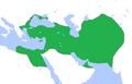
Map depicting the Achaemenid Empire.
-
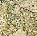
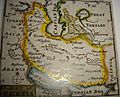
1598 German map of the region.
-
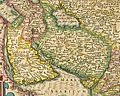
1610 map by Dutch map maker Jodocus Hondius showing Bactria and Georgia among the territories.
-
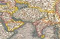
1719 map depiction of Asia.
-
1720 map by Herman Moll.
-
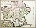
1753 map by Robert de Vaugondy titled Estats du Grand-Seigneur en Asie where the color yellow marks the territories of Persia.
-
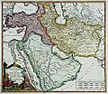
1808 British map of Persia.
-
1814 map of Persia by John Thomson.
-
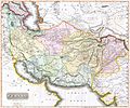
19th century British map depicting Persia


Important Treaties
- 1555 Treaty of Amasya: This was the first treaty between Safavid Persia and the Ottoman Empire. It divided the Caucasus and Mesopotamia into Turkish and Persian areas.
- 1639 Treaty of Zuhab: Iran lost Iraq to the Ottoman Empire.
- 1813 Gulestan Treaty: Iran lost a large amount of land in the Caucasus. This included eastern Georgia, southern Dagestan, large parts of Armenia, and most of what is now the Azerbaijan Republic.
- 1828 Turkmenchay Treaty: Signed by Fath-Ali Shah Qajar. Russia gained control over the entire Caucasus. This included Iran's Nakhichivan, Nagorno-Karabakh, all of Armenia, and the rest of modern-day Azerbaijan.
- 1857 Paris Treaty: Signed by Nasereddin Shah. Iran gave up all claims to Herat and parts of Afghanistan. In return, Great Britain left Iran's southern ports.
- 1881 Akhal Treaty: Signed by Nasereddin Shah. Iran lost Merv and parts of Khwarazmia. In return, Russia gave security promises.
- 1893: Iran gave more regions near the Atrek River to Russia. These areas were Iranian under the Akhal Treaty.
- 1907: Persia was divided into three regions by the Anglo-Russian Convention of 1907.
- 1970: Iran gave up its claims to Bahrain to Great Britain. In return, Iran gained the Greater and Lesser Tunbs and Abu Musa islands in the Persian Gulf.
Images for kids
-
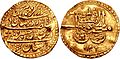
A coin of Nader Shah (ruled 1736–1747). It says: "Coined on gold the word of kingdom in the world, Nader of Greater Iran and the world-conquerer king."
-
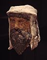
Painted clay and alabaster head of a Zoroastrian priest wearing a special headdress from Bactria, Takhti-Sangin, Tajikistan, Greco-Bactrian kingdom, 3rd-2nd century BC.

,_Temple_of_the_Oxus,_Takht-i-Sangin,_3rd-2nd_century_BCE_(left_side).jpg)
See also
 In Spanish: Gran Irán para niños
