Greater Khorasan facts for kids
Quick facts for kids
(Greater) Khorasan
خراسان (بزرگ)
Historical Khorasan or Ancient Khorasan
|
|
|---|---|
|
|
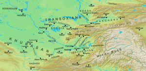
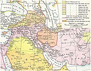
Map of Khorasan and its surroundings in the 7th/8th centuries
|
|
| Countries in Khorasan | Iran, Turkmenistan and Afghanistan. Different regions of Tajikistan, Uzbekistan, Kyrgyzstan and Kazakhstan are also included in different sources |
| Demonym(s) | Khorasani (Persian: خراسانی) |
| Ethnicities | |
Greater Khorasan or Khorasan (Middle Persian: Xwarāsān; Persian: خراسان [xoɾɒːˈsɒːn]) is a large historical region in the Iranian Plateau. It sits between Western and Central Asia. The name Khorasan comes from the Persian language. It means "where the sun comes from" or "the Eastern Province."
This name was first used for the eastern part of Persia during the Sasanian Empire. Later, in the Middle Ages, it helped tell this area apart from nearby Transoxiana. Today, "Greater Khorasan" helps us know the larger historical area. It is different from the smaller Khorasan Province in Iran (which existed from 1906 to 2004). That province covered only the western half of the historical Greater Khorasan.
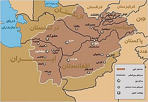
Khorasan included parts of what is now northeastern Iran, Afghanistan, and southern Central Asia. This big region was often split into four main areas. The main cities for these areas were Nishapur (in modern Iran), Marv (in modern Turkmenistan), Herat, and Balkh (both in modern Afghanistan). In its strictest sense, Khorasan reached the Amu Darya (Oxus) river. But sometimes, the name was used more broadly. This wider area included most of Transoxiana (with cities like Bukhara and Samarqand in modern Uzbekistan). It also stretched west to the Caspian coast, south to Sistan, and east to the Pamir Mountains.
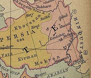
Khorasan became an official administrative area in the 6th century. This happened under the Sasanians, during the rule of Kavad I (r. 488 – 496) or Khosrow I (r. 531 – 579). It covered the eastern and northeastern parts of their empire. After the early Islamic conquests, people often thought of everything east of Jibal (later called Iraq Ajami) as part of a huge, loosely defined Khorasan. This could even reach the Indus Valley and the Pamir Mountains. The border between these two areas was near the cities of Gurgan and Qumis. Later, empires like the Ghaznavids, Seljuqs, and Timurids divided their lands into Iraqi and Khorasani regions. Khorasan was thought to be bordered in the southwest by a desert and the town of Tabas. Tabas was known as "the Gate of Khorasan." From there, it went east to the mountains of central Afghanistan. By the 10th century, areas south of the Hindu Kush were called the Khorasan Marches. This was a border region between Khorasan and Hindustan.
Contents
What is the Geography of Khorasan?
Khorasan was first set up in the 6th century. It was one of four military areas by the Sasanian Empire. Over its long 1,500-year history, its size changed a lot. At first, the Sasanian Khorasan included cities like Nishapur, Herat, Merv, Faryab, Taloqan, Balkh, Bukhara, Badghis, Abiward, Gharjistan, Tus, and Sarakhs.
When the Umayyad Caliphate rose, they also used the name Khorasan. It stretched as far as their eastern military gains. This started with military bases in Nishapur and Merv. It slowly grew east into Tokharistan and Sogdia. Under the Caliphs, Khorasan was one of three main political zones. The other two were Eraq-e Arab (Arabic Iraq) and Eraq-e Ajam (Persian Iraq). Under the Umayyad and Abbasid caliphates, Khorasan was split into four main sections. Each section was based on a major city: Nishapur, Merv, Herat, and Balkh.
By the 10th century, writers like Ibn Khordadbeh and the Hudud al-'Alam described Khwarasan as covering the areas of Abarshahr, Tokharistan, and Sogdia. They also said that the southern part of the Hindu Kush, including Sistan, Rukhkhudh, Zabulistan, and Kabul, formed the Khorasan marches. This was a border area between Khorasan and Hindustan.
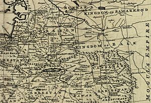
Later, in the Middle Ages, the name Khorasan lost its official administrative meaning. In the west, it was loosely used by Turko-Persian rulers of modern Iran. It referred to all their lands east and northeast of the Dasht-e Kavir desert. So, its size changed as empires grew and shrank. In the east, Khwarasan became linked to the big cities of Central Asia. The Memoirs of Babur mentions:
The people of Hindustān call every country beyond their own Khorasān, in the same manner as the Arabs term all except Arabia, Ajem. On the road between Hindustān and Khorasān, there are two great marts: the one Kābul, the other Kandahār. Caravans, from Ferghāna, Tūrkestān, Samarkand, Balkh, Bokhāra, Hissār, and Badakhshān, all resort to Kābul; while those from Khorasān repair to Kandahār. This country lies between Hindustān and Khorasān.
Today, the term Khorasan brings up feelings of nostalgia and national pride, especially among the Tajiks of Central Asia. Many Tajiks see Khorasan as a key part of their identity. This has kept interest in the term alive, even though it's no longer used politically in the region. According to Ghulam Mohammad Ghobar, Afghanistan's current Persian-speaking areas made up most of Khorasan. This is because two of Khorasan's four main capitals (Herat and Balkh) are now in Afghanistan. Ghobar used "Proper Khorasan" and "Improper Khorasan" to show the strict and loose meanings of the term. He said Proper Khorasan was between Balkh in the east, Merv in the north, Sistan in the south, Nishapur in the west, and Herat (the "Pearl of Khorasan") in the center. Improper Khorasan stretched to Hazarajat and Kabul in the east, Baluchistan in the south, Transoxiana and Khwarezm in the north, and Damghan and Gorgan in the west.
A Brief History of Khorasan
Ancient Times
Before Alexander the Great conquered the region in 330 BC, Khorasan was part of the Achaemenid Empire of Persia. Before that, the Medes ruled it. The land that became Khorasan was known as Ariana by the Greeks. This area was part of Greater Iran, where Zoroastrianism was the main religion. In the 1st century AD, the southeastern part of Khorasan was taken by the Kushan Empire. The Kushan rulers built a capital in modern-day Afghanistan at Bagram. They are also believed to have built the famous Buddhas of Bamiyan. Many Buddhist temples and old buried cities have been found in Afghanistan.
However, Khorasan mostly remained Zoroastrian. But there were also followers of Manichaeism, sun worshippers, Christians, Pagans, Shamanists, Buddhists, Jews, and Hindus. One of the three great fire-temples of the Sasanids, "Azar-burzin Mehr," is near Sabzevar in Iran. The borders of the region changed until the Kushans and Sasanids joined to form the Kushano-Sasanian civilization.
During the Sasanian era, probably under Khusrow I, Persia was divided into four regions. These were Khwārvarān in the west, apāxtar in the north, nīmrūz in the south, and Khorasan in the east. Since Sasanian lands stayed mostly the same until the Islamic conquests, we can say Sasanian Khorasan was bordered by Sistan and Kerman to the south. To the west were the central deserts of modern Iran, and to the east were China and India.
Sasanian Khorasan was further divided into four smaller areas. Each area was ruled by a marzban. These four regions were Nishapur, Marv, Herat, and Balkh.
Khorasan in the east saw some fighting with the Hephthalites. They became the new rulers in the area, but the borders stayed stable. As the eastern part of the Sasanid Empire, and further from Arabia, Khorasan was conquered after the rest of Persia. The last Sasanid king of Persia, Yazdgerd III, moved his throne to Khorasan after the Arab invasion in the western parts of the empire. After the king was killed, Arab Muslims conquered Khorasan in 647 AD. Like other Persian provinces, it became a province of the Umayyad Caliphate.
Medieval Times
- Further information: Rashidun Caliphate, Umayyad Caliphate, and Abbasid Caliphate
The first major movement against Arab rule was led by Abu Muslim Khorasani between 747 and 750. Abu Muslim was likely Persian. He helped the Abbasids come to power. However, he was later killed by Al-Mansur, an Abbasid Caliph.
The first kingdom independent from Arab rule in Khorasan was set up by Tahir Phoshanji in 821. Other important independent dynasties that ruled Khorasan included the Saffarids (861–1003), Samanids (875–999), Ghaznavids (963–1167), Seljuqs (1037–1194), Khwarezmids (1077–1231), Ghurids (1149–1212), and Timurids (1370–1506). In 1221, Genghis Khan's son Tolui led the Mongol conquest of Khorasan. This conquest was so thorough that the region took a very long time to recover.
Rashidun Era (651–661)
Under Caliph Umar (r. 634 – 644), the Rashidun Caliphate took almost all of Persia from the Sasanian Empire. But Khorasan was not fully conquered until around c. 651. This happened during the time of Caliph Uthman (r. 644 – 656). Rashidun commanders Ahnaf ibn Qays and Abd Allah ibn Amir led the invasion. In late 651, the Rashidun army defeated the combined forces of the Sasanian and the First Turkic Khaganate in the Battle of the Oxus River. The next year, Ibn Amir made a peace treaty with Kanadbak, an Iranian nobleman from Tus. A Sasanian rebel named Burzin Shah fought against Ibn Amir, but the rebels were crushed in the Battle of Nishapur. The Rashidun troops then marched to Herat and took the city, making another treaty with its governor.
Umayyad Era (661–750)
After the Arab conquest of Persia, new challenges arose for the caliphate. Some tribal groups in the Afghan areas continued to resist for centuries. During the 7th century, Arab armies moved into Afghanistan from Khorasan. Another issue was that the Muslims now bordered the city-states of Transoxiana. Transoxiana was part of a loosely defined "Turkestan" region. However, only the rulers were partly Turkic; most local people were a mix of Iranian groups. As Arabs reached Transoxiana, local Iranian-Turkic and Arab armies fought for control of the important Silk Road cities. Two important Umayyad generals, Qutayba ibn Muslim and Nasr ibn Sayyar, were key to the eventual conquest. In July 738, Nasr became governor of Khorasan. He was respected for his military skills and knowledge of the region.
Abbasid Era (750–861)
Khorasan became the main base for the Abbasid Revolution against the Umayyads. This revolution was led by Abu Muslim, who was from Khorasan. This province was part of the Iranian world that had been settled by many Arab tribes after the Muslim conquest. The goal was to replace the Umayyad dynasty, which was successfully achieved under the symbol of the Black Standard.
Modern Times
Between the early 16th and early 18th centuries, parts of Khorasan were fought over by the Safavids and the Uzbeks. In 1722, a part of Khorasan was conquered by the Ghilji Pashtuns from Kandahar. It became part of the Hotaki dynasty from 1722 to 1729. Nader Shah took back Khorasan in 1729 and made Mashhad the capital of Persia. After he was killed in 1747, the eastern parts of Khorasan, including Herat, were added to the Durrani Empire. The Mashhad area was controlled by Nader Shah's grandson, Shahrukh Afshar, until the Qajar dynasty captured it in 1796.
In 1856, the Iranians, under the Qajar dynasty, briefly took back Herat. But by the Treaty of Paris of 1857, signed between Iran and the British Empire, Iranian troops left Herat. Later, in 1881, Iran gave up its claims to some northern areas of Khorasan to the Russian Empire. This mainly included Merv, as part of the Treaty of Akhal.
Why is Khorasan Culturally Important?
Khorasan has been very important culturally among other regions in Greater Iran. The literary New Persian language developed in Khorasan and Transoxiana. It slowly replaced the Parthian language. Early Persian literature grew and thrived in Khorasan and Transoxiana. This is where early Iranian dynasties like the Tahirids, Samanids, Saffirids, and Ghaznavids were based. Early Persian poets such as Rudaki, Shahid Balkhi, and Ferdowsi were from Khorasan. The famous poet Rumi was also from Khorasan.
Until the terrible Mongol invasion in the 13th century, Khorasan was the cultural center of Persia. Many famous scientists came from Khorasan. These include Avicenna, Al-Farabi, Al-Biruni, Omar Khayyam, Al-Khwarizmi, and Nasir al-Din al-Tusi. They are known for their big contributions to math, astronomy, medicine, physics, geography, and geology. Khorasan artisans also helped spread technology and goods along old trade routes. This included art, textiles, and metalworks with animal designs. The decorative ideas for the famous "singing bowls" of Asia might have come from ancient Khorasan.
In Islamic theology, law, philosophy, and Hadith collection (sayings of the Prophet Muhammad), many great Islamic scholars came from Khorasan. These include Imam Bukhari, Imam Muslim, Al-Ghazali, and Fakhr al-Din al-Razi. Shaykh Tusi, a Shi'a scholar, was from Khorasan. The grandfather of Imam Abu Hanifa was also from Khorasan.
See also
 In Spanish: Gran Jorasán para niños
 | Claudette Colvin |
 | Myrlie Evers-Williams |
 | Alberta Odell Jones |


