
Kandahar Province facts for kids
Quick facts for kids
Kandahar
|
|
|---|---|

View of Arghandab River Valley
|
|
| Nickname(s):
Loy kandahar
|
|

Map of Afghanistan with Kandahar highlighted
|
|
| Country | |
| Capital | Kandahar |
| Area | |
| • Total | 54,022 km2 (20,858 sq mi) |
| Population
(2012)
|
|
| • Total | 1,151,100 |
| • Density | 21.3080/km2 (55.1874/sq mi) |
| Time zone | UTC+4:30 |
| Area code(s) | AF-KAN |
| Main languages | Pashto |
Kandahar or Qandahar (Pashto: کندھار or قندهار) (Persian: قندهار) is one of the largest of the thirty-four provinces of Afghanistan. It is located in southern Afghanistan, between Helmand, Oruzgan and Zabul provinces. Its capital is the city of Kandahar. About 1.1 million people live in the province.
Districts of Kandahar
Kandahar Province is divided into several smaller areas called districts. These districts help manage the different parts of the province.

Some of the districts include:
- Arghandab
- Kandahar (where the capital city is located)
- Panjwayi
- Spin Boldak
- Zhari
These districts have different populations, with the Kandahar District being the most populated. Some districts were created or changed in 2005 to better organize the province.
 |
Orūzgān Province | Zabul Province | |
|
| Helmand Province | ||||
| Balochistan, |
Images for kids
-
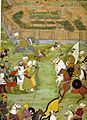
A miniature from Padshahnama showing the surrender of the Shia Safavid at what is now Old Kandahar in 1638 to the Mughal army of Shah Jahan commanded by Kilij Khan
-
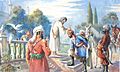
Painting by Abdul Ghafoor Breshna showing the 1747 coronation of Ahmad Shah Durrani, who is seen as the founding father of Afghanistan.
-
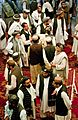
A gathering of tribal leaders in Kandahar.
-
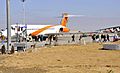
A Kam Air passenger plane at Kandahar International Airport in 2012
-
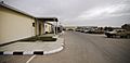
The Kandahar Regional Military Hospital in 2007.
-
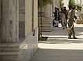
A Kandahar University student sweeping the sidewalk in June 2012.


See also
 In Spanish: Provincia de Kandahar para niños
