
Uruzgan Province facts for kids
Quick facts for kids
Uruzgan
ارزگان
|
|
|---|---|

Aerial photograph of fields in Uruzgan Province
|
|

Map of Afghanistan with Uruzgan highlighted
|
|
| Country | |
| Capital | Tarinkot |
| Area | |
| • Total | 12,640 km2 (4,880 sq mi) |
| Population
(2020)
|
|
| • Total | 436,079 |
| Time zone | UTC+4:30 (Afghanistan Time) |
| ISO 3166 code | AF-URU |
| Main languages | Dari and Pashto |
Uruzgan (Template:Dari), also known as Urozgan or Oruzgan, is one of the 34 provinces of Afghanistan. It is located in the center of the country. About 436,079 people live here, and it is mostly a tribal society. Tarinkot is the capital city of Uruzgan province.
In 2004, a new province called Daykundi Province was created from a northern part of Uruzgan. Uruzgan shares borders with the provinces of Kandahar, Daykundi, Ghazni, Zabul, and Helmand.
Contents
Where is Uruzgan Located?
Uruzgan province is in southern Afghanistan. It borders Zabul and Kandahar to the south. To the southwest is Helmand, to the north is Daykundi, and to the east is Ghazni.
Uruzgan covers an area of about 12,640 square kilometres (4,880 sq mi). Much of the province has mountains or hilly areas. The rest of the land is flat.
A Look Back: Uruzgan's History
The history of Uruzgan goes back a very long time. It was once part of an ancient region called Arachosia. Many different empires and groups have ruled this land over the centuries.
The Medes ruled before the Achaemenids took over. In 330 BC, Alexander the Great came to the area. After him, the Seleucids ruled. Later, the Mauryas, led by Ashoka, took control.
In the 7th century, the Arabs arrived and brought Islam to the region. The Saffarids then conquered the area in the 9th century. After them, the Ghaznavids and Ghurids ruled. In the 13th century, the Mongols invaded.
Later, the area was ruled by the Ilkhanate, then the Timurids, Mughals, and Safavids.
The Rise of Afghanistan
In 1709, the Hotak dynasty became powerful in Kandahar. They defeated the Safavids and took control of southern Afghanistan.
In 1747, a leader named Ahmad Shah Durrani united the Afghans. Uruzgan was one of the first areas to become part of his new Durrani Empire. This empire eventually became the modern country of Afghanistan.
Recent Times
During the Soviet–Afghan War in the 1980s, there was fighting in Uruzgan. Local fighters, called the Mujahideen, fought against pro-Soviet forces.
In late 1994, the Taliban took control of Uruzgan. They were removed from power by forces led by the United States in late 2001. Hamid Karzai, who later became the President of Afghanistan, arrived in Uruzgan in late 2001 to help take control of the area.
Recent Events

In June 2002, there was a sad event where a wedding party in Uruzgan was accidentally bombed by the U.S. Air Force, leading to civilian deaths.
After the Taliban fell, Jan Mohammad Khan governed the province from 2002 to 2006. He was an ally of President Karzai. In 2006, Maulavi Abdul Hakim Munib, a former Taliban official who joined the government, replaced him.
In 2006, a NATO-led force called the International Security Assistance Force (ISAF) took over security in Uruzgan. The Netherlands and Australia also had troops helping to keep the peace.
_with_the_56th_Infantry_Brigade_Combat_Team,_Texas_Army_National_Guard,_watches_Afghans_pass_during_a_logistics_130604-A-FS372-018.jpg)
In June 2007, Dutch, American, Australian, and Afghan soldiers defended the town of Chora against an attack. This was one of the biggest attacks that year.
In August 2010, the Dutch forces left Uruzgan province. The United States and Australia continued the mission.
Getting Around: Transportation
As of May 2014, Uruzgan province has the Tarinkot Airport. This airport has regular flights to Kabul.
Staying Healthy: Healthcare
Access to clean drinking water has improved in Uruzgan. In 2005, only 8% of homes had clean water, but by 2011, this increased to 27%.
The number of births attended by a skilled health worker also increased. It went from 6% in 2005 to 14% in 2011.
Learning and Education
Education has also seen improvements. The number of people aged 6 and older who can read and write (literacy rate) went up from 5% in 2005 to 17% in 2011.
More children are also going to school. The number of children aged 6-13 enrolled in school increased from just 1% in 2005 to 49% in 2011.
Who Lives in Uruzgan?

In 2020, Uruzgan province had about 436,079 people. There are an estimated 45,000 households, with about six people in each family on average.
Most of the people who live in Uruzgan belong to the Pashtuns and Hazaras ethnic groups. There are also some Kuchi nomads, who are people who move from place to place. Their numbers change depending on the season.
Districts of Uruzgan
Uruzgan province is divided into several districts:
| District | Capital | Population |
|---|---|---|
| Shahidi Hassas | 86,100 | |
| Chora | 98,750 | |
| Deh Rawood | Deh Rawood | 99,718 |
| Khas Uruzgan | 96,888 | |
| Tarinkot | Tarinkot | 110,476 |
Images for kids
-
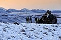
Soldiers from Australia's Special Operations Task Group (SOTG) in December 2009.

See also
 In Spanish: Provincia de Uruzgán para niños
