
Zabul Province facts for kids
Quick facts for kids Zabul (زابل) |
|
| Province | |
| Country | Afghanistan |
|---|---|
| Capital | Qalat |
| - coordinates | 32°06′N 67°06′E / 32.1°N 67.1°E |
| Area | 17,343 km² (6,696 sq mi) |
| Population | 276,100 |
| Timezone | UTC+4:30 |
| Main language | Pashto |
Zabul (pronounced ZAH-bool) is a special province in the southern part of Afghanistan. Its capital city is Qalat. About 276,100 people live here. Most of the people in Zabul are from the Pashtun ethnic group.
Contents
What is Zabul Province Like?
Zabul is surrounded by other provinces in Afghanistan. To the east, you'll find Paktika and Ghazni provinces. Urozgan province is to the north. Kandahar province is to the west and southwest. To the south, Zabul borders the Balochistan state of Pakistan.
Most people in Zabul, around 80%, are farmers. They grow many different crops. Some of the main farm products include almonds, grapes, apricots, wheat, and various vegetables.
The current governor of Zabul province is Mr. Bissmillah Afghanmal. He was born in Kandahar in 1976.
Districts of Zabul

Zabul province is divided into several smaller areas called districts. These districts help manage different parts of the province. There are 11 districts in Zabul province:
- Argahandab District
- Atghar District
- Daychopan District
- Kakar District
- Mizan District
- Naw Bahar District
- Qalat District
- Shah Joy District
- Shamulzayi District
- Shinkay District
- Tarnak Aw Jaldak District
Getting Around Zabul
In 2006, Zabul province got its very first airstrip. It was built near Qalat, the capital city. This airstrip was mainly for the Afghan National Army. It is not a paved runway.
 |
Orūzgān Province | Ghazni Province | |
|
| Paktika Province | ||||
| Kandahar Province | Balochistan, |
Images for kids
-

Almond trees in Zabul Province
-

Bibi Khala School in Qalat
-
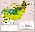
Ethnolinguistic groups of Afghanistan
-

Afghan National Police 1st Lt. Sardar Hotak speaks before a graduation ceremony for Afghan Local Police cadets.
-
Afghan police and coalition special operations forces help a police member needing medical care (January 2012).
-
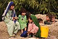
Afghan children watch U.S. Soldiers and Airmen in their village (August 2010).
-
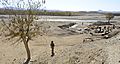
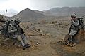
Sgt. Johnny Hoyos patrolling near a bridge on the Kabul–Kandahar Highway in 2010.
-
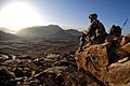
A U.S. soldier watches the sunrise after a patrol mission near Forward Operating Base Baylough.
-
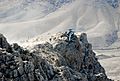
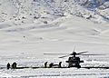
U.S. Special Forces are extracted from a mountain in Zabul province.
-
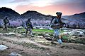
An early-morning patrol mission near Forward Operating Base Baylough, Zabul.
-
U.S. soldiers drinking tea at an Afghan National Army outpost.


See also
 In Spanish: Provincia de Zabul para niños
