
Paktika Province facts for kids
Quick facts for kids Paktika (پکتیکا) |
|
| Province | |
 |
|
| Country | Afghanistan |
|---|---|
| Capital | Sharana |
| - coordinates | 32°30′N 68°48′E / 32.5°N 68.8°E |
| Area | 19,482 km² (7,522 sq mi) |
| Population | 393,800 (2009) |
| Timezone | UTC+4:30 |
| Main language | Pashto |
Paktika (Pashto: پکتیکا) is one of the 34 provinces in Afghanistan. It is located in the southeastern part of the country. Most of the people living here are Pashtun. The capital city of Paktika is Sharana.
Contents
Understanding Paktika Province
Paktika is an important region in Afghanistan. It shares borders with other provinces and even with Pakistan. The main language spoken by the people is Pashto. The province covers a large area of about 19,482 square kilometers. In 2009, its population was around 393,800 people.
Where is Paktika Located?
Paktika Province is surrounded by several other areas.
 |
Paktia Province | Khost Province | |
|
| Ghazni Province | Federally Administered Tribal Areas, |
|||
| Zabul Province | Balochistan, |
Districts of Paktika

Paktika Province is divided into many smaller areas called districts. Each district helps manage the local communities. Here is a list of the districts and their populations:
| District Name | Population |
|---|---|
| Barmal | 88,028 |
| Dila | 50,203 |
| Gayan | 42,495 |
| Gomal | 64,275 |
| Janikhel | 35,251 |
| Mata Khan | 19,758 |
| Nika | 15,103 |
| Omna | 25,690 |
| Sar Hawza | 36,236 |
| Surobi | 48,291 |
| Sharana | 54,416 |
| Terwa | 15,332 |
| Urgun | 89,718 |
| Waza Khwa | 50,818 |
| Wor Mamay | 30,135 |
| Yahyakhel | 30,161 |
| Yusufkhel | 32,648 |
| Zarghun Shar | 38,024 |
| Ziruk | 43,190 |
Images for kids
-
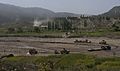
A convoy with members of Task Force 2–28, 172nd Infantry Brigade and the Afghan National Army winds its way through a small valley on its way back to Forward Operating Base Orgun-E from Combat Outpost Zerok
-
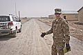
Forward Operating Base Super FOB commander explaining the paving process for one of the streets of Camp Super FOB, which will be the largest training and operations base for the Afghan National Army when completed.
-
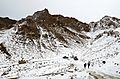
Afghan Local Police and ANSF moving up a mountain pass
-
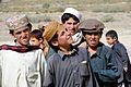
Local Afghan children observe U.S. Army Special Forces and Afghan National Police as they patrol the area to improve security and increase stability in the village of Rabat.
-
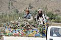
Local Afghans leaving the village of Rabat, hauling firewood in their pickup
-
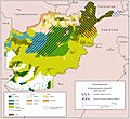
Ethnolinguistic groups of Afghanistan


.jpg)


See also
 In Spanish: Provincia de Paktiká para niños
