
Federally Administered Tribal Areas facts for kids
Quick facts for kids
Federally Administered Tribal Areas
(Pashto: منځنۍ پښتونخوا)
|
|||
|---|---|---|---|

Bab-e-Khyber
|
|||
|
|||
.svg)
Location of the Federally Administered Tribal Areas
|
|||
| Country | |||
| Administrative unit | Federal territory | ||
| Components | 7 Agencies 6 Frontier Regions |
||
| Administrative centre | Peshawar | ||
| Area | |||
| • Total | 27,220 km2 (10,510 sq mi) | ||
| Population
(1998)
|
|||
| • Total | 3,176,331 | ||
| • Density | 116.691/km2 (302.23/sq mi) | ||
| Time zone | UTC+5 | ||
| Website | http://www.fata.gov.pk/ | ||


The Federally Administered Tribal Areas (FATA) were a special region in Pakistan. They were located outside the four main provinces of the country. This area covered about 27,220 square kilometers (10,507 square miles).
FATA was made up of seven main areas called Agencies and six smaller areas known as Frontier Regions. The city of Miran Shah was considered the main tribal capital. This region was officially created on July 1, 1970.
The seven Agencies were:
- Bajaur Agency
- Khyber Agency
- Kurram Agency
- Mohmand Agency
- Orakzai Agency
- North Waziristan Agency
- South Waziristan Agency
Frontier Regions

The Frontier Regions were named after the districts next to them. These regions were managed by local officials from the neighboring districts. The main office for FATA, called the FATA Secretariat, was in Peshawar. This office reported to the Governor of Khyber-Pakhtunkhwa.
The six Frontier Regions were:
- Frontier Region Bannu
- Frontier Region Dera Ismail Khan
- Frontier Region Kohat
- Frontier Region Lakki Marwat
- Frontier Region Peshawar
- Frontier Region Tank (Jandola)
Geography of FATA
The Federally Administered Tribal Areas had interesting borders. To the west, they shared a border with Afghanistan, marked by a line called the Durand Line. To the north and east, FATA was next to the Pakistani province of Khyber-Pakhtunkhwa. To the south, it bordered Balochistan.
The seven Tribal Agencies were arranged in a long strip from north to south. Right next to them, also in a north-to-south strip, were the six Frontier Regions.
Here's how the seven Tribal Agencies were lined up from north to south: Bajaur Agency, Mohmand Agency, Khyber, Orakzai Agency, Kurram, North Waziristan, and South Waziristan.
The six Frontier Regions were also arranged from north to south: Peshawar, Kohat, Bannu, Lakki Marwat, Tank, and Dera Ismail Khan.
Images for kids
-
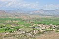
Mohmand Agency
-
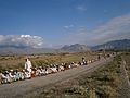
Pashtuns in the Baizai area


See also
 In Spanish: Áreas tribales (Pakistán) para niños
