
Kurram Agency facts for kids
Quick facts for kids
Kurram District
|
|
|---|---|
|
District
|
|
.jpg)
Kurram Agency of Pakistan
|
|
| Country | |
| Province | Khyber Pakhtunkhwa |
| Headquarter | Parachinar |
| Number of Tehsils | 3 |
| Area | |
| • Total | 3,380 km2 (1,310 sq mi) |
| Population
(2017)
|
|
| • Total | 619,553 |
| • Density | 183.30/km2 (474.7/sq mi) |
| Time zone | UTC+5 (PST) |
| Main language | Pashto (98.6%) |
Kurram District is a special area in Khyber Pakhtunkhwa province in Pakistan. It's called a district, which is like a region or a county. Before 2018, it was known as an agency within the Federally Administered Tribal Areas. When these tribal areas joined Khyber Pakhtunkhwa, Kurram became a district.
This district covers the beautiful Kurram Valley. This valley is in the northwestern part of Pakistan. Most people living here are Pashtuns. Their main religion is Islam, with both Shia and Sunni followers.
Contents
About Kurram District
The name Kurram comes from the Kurram River. This river flows right through the valley. To the north, you'll see tall, snow-covered mountains called the Safed Koh. These mountains also form a natural border with Afghanistan. The valley is very green and fertile because it has lots of water for farming. You'll find many small villages, fruit orchards, and groves here.
Where is Kurram Located?
Kurram District is part of the Kohat Division in Khyber Pakhtunkhwa. Before the year 2000, it was part of the Peshawar Division. This was when the old administrative divisions were changed.
Important Towns and Features
The main towns in Kurram District include Parachinar, Sadda, and Alizai. Parachinar is the main headquarters of the district. A place called Zeran Dam is located northeast of Parachinar. It's known for its lovely scenery.
Kurram Valley's History
In ancient times, the Kurram Valley was a very important route. It offered the most direct way to reach cities like Kabul and Gardez. This route went over a high mountain pass, about 3,439 meters (11,283 feet) tall. This pass is just over 20 kilometers west of modern Parachinar and sadda. However, the pass would be blocked by snow for several months each year, making travel difficult.
Images for kids
-
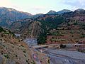
Bridge in Tari Mengal
-
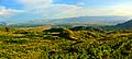
View at Makay near Malana
-
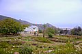
Makay village, upper Kurram


