Gardez facts for kids
Quick facts for kids
Gardez
Persian: گردیز
|
|
|---|---|
|
City
|
|

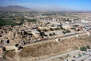
The Bala Hesar fortress in the center of Gardez City
|
|
| Country | |
| Province | Paktia Province |
| District | Gardez District |
| Elevation | 2,308 m (7,572 ft) |
| Population
(2008)
|
|
| • City | 70,000 |
| • Urban | 70,641 |
| Time zone | UTC+4:30 (Afghanistan Standard Time) |
Gardez (Pashto: ګردېز / Persian: گردیز) is a city in Afghanistan. Its name means "mountain fortress" in an old language called Middle Persian. Gardez is the capital of the Paktia Province.
In 2008, about 70,000 people lived there. Most of the people are from the Pashtun group. The city sits where two important roads meet in a big valley. It is surrounded by the Hindu Kush mountains.
Gardez is a key place for trade in eastern Afghanistan. It has been important for armies throughout history. You can still see old observation posts built by Alexander the Great nearby. In 2015, Gardez had a population of 70,641 people. It has 13 areas called districts.
On August 14, 2021, the city was taken over by Taliban fighters. This was part of a larger event where the Taliban took control of many cities.
Contents
Gardez Through Time
Gardez is a very old city. It is located in a large valley within the Sulaiman Mountains. Old coins found here show its rich history. These coins are from different groups like the Greeks, Sassanids, Hephthalites, and Hindu Shahi.
Early Rulers and Islam
In the 8th century, the rulers of Gardez were from the Lawik dynasty. They used to follow Hinduism or Buddhism. Later, they became followers of Islam. Gardez also became a center for a group called the Khawarij. Because of this, the city was attacked many times.
Around 877, a ruler named Emir Ya'qub ibn al-Layth al-Saffar made the Lawik rulers pay him tribute. But the Lawiks still controlled Gardez for about 100 more years. In 975, a governor tried to take Gardez but was killed. In 1162, the city was taken by the Ghurid dynasty.
Mughal Era and Modern Times
In the 1500s, Gardez was known for its tall houses. This was written by Baburs in his book, Baburnama. It was also a main center for the Mughal Empire in the "Zurmat District".
Today, Gardez is the main city of the Paktia Province. In 1979, about 44,000 people lived in the area. However, many people left during the Soviet–Afghan War in the 1980s.
In 1960, the German government started a big project to help develop Paktiā. This brought a lot of money to the area. Because of this, the number of shops in the market grew a lot. It went from 117 shops in 1965 to over 600 in 1977. This economic growth ended when the communist government took power in 1979.
During the 1980s, the government lost control of most of Paktiā. Only Gardez remained under government control. In 2002, a local leader named Pacha Khan Zadran attacked the city. He had been chosen as governor but was not accepted by tribal elders.
On January 4, 2002, the first American soldier to die in the War in Afghanistan (2001–2021) was killed in Gardez. His name was Sergeant First Class Nathan Chapman.
Gardez's Location and Environment
Gardez is located very high up, at 2,308 meters (7,572 feet) above sea level. This makes it one of the highest provincial capitals in Afghanistan. It is also close to the Tora Bora region, known for its caves.
The "old town" of Gardez is at the bottom of the Bālā Hesār fortress. The Gardez River flows through the city. This river eventually goes into the Ab-i Istada lake.
Gardez is an important meeting point for two roads. One road connects Kabul with Khost. The other links Ghazni with Parachinar in Pakistan. Gardez is about 70 kilometers (43 miles) northwest of Khost. It is also about 100 kilometers (62 miles) south of Kabul.
Gardez Climate
Gardez has a cold semi-arid climate. This means it has dry summers and cold, snowy winters. It does not get much rain, and most of it falls in winter and spring.
| Climate data for Gardez | |||||||||||||
|---|---|---|---|---|---|---|---|---|---|---|---|---|---|
| Month | Jan | Feb | Mar | Apr | May | Jun | Jul | Aug | Sep | Oct | Nov | Dec | Year |
| Record high °C (°F) | 14.6 (58.3) |
12.7 (54.9) |
24.7 (76.5) |
26.5 (79.7) |
31.0 (87.8) |
34.5 (94.1) |
34.8 (94.6) |
33.8 (92.8) |
30.0 (86.0) |
27.8 (82.0) |
20.0 (68.0) |
17.6 (63.7) |
34.8 (94.6) |
| Mean daily maximum °C (°F) | 1.0 (33.8) |
2.3 (36.1) |
8.8 (47.8) |
16.8 (62.2) |
22.2 (72.0) |
27.8 (82.0) |
29.6 (85.3) |
29.0 (84.2) |
25.1 (77.2) |
18.6 (65.5) |
11.9 (53.4) |
5.7 (42.3) |
16.6 (61.8) |
| Daily mean °C (°F) | −6.1 (21.0) |
−4.7 (23.5) |
2.7 (36.9) |
10.1 (50.2) |
15.1 (59.2) |
20.6 (69.1) |
22.0 (71.6) |
21.1 (70.0) |
16.7 (62.1) |
10.5 (50.9) |
3.8 (38.8) |
−2.2 (28.0) |
9.1 (48.4) |
| Mean daily minimum °C (°F) | −11.7 (10.9) |
−10.1 (13.8) |
−2.3 (27.9) |
4.0 (39.2) |
7.9 (46.2) |
12.5 (54.5) |
14.9 (58.8) |
13.8 (56.8) |
8.4 (47.1) |
2.3 (36.1) |
−2.8 (27.0) |
−7.6 (18.3) |
2.4 (36.4) |
| Record low °C (°F) | −31 (−24) |
−30.0 (−22.0) |
−19.6 (−3.3) |
−6.4 (20.5) |
−2.5 (27.5) |
4.7 (40.5) |
9.0 (48.2) |
4.5 (40.1) |
0.5 (32.9) |
−9.3 (15.3) |
−13.2 (8.2) |
−27.8 (−18.0) |
−31 (−24) |
| Average precipitation mm (inches) | 35.8 (1.41) |
61.7 (2.43) |
65.5 (2.58) |
50.4 (1.98) |
21.7 (0.85) |
4.8 (0.19) |
15.8 (0.62) |
7.5 (0.30) |
0.9 (0.04) |
5.8 (0.23) |
12.4 (0.49) |
33.2 (1.31) |
315.5 (12.43) |
| Average rainy days | 1 | 1 | 6 | 9 | 6 | 2 | 3 | 2 | 0 | 2 | 3 | 1 | 36 |
| Average snowy days | 8 | 8 | 5 | 1 | 0 | 0 | 0 | 0 | 0 | 0 | 1 | 6 | 29 |
| Average relative humidity (%) | 69 | 72 | 66 | 58 | 47 | 39 | 49 | 51 | 45 | 45 | 51 | 60 | 54 |
| Mean monthly sunshine hours | 171.5 | 166.8 | 214.2 | 242.9 | 316.2 | 357.5 | 343.0 | 335.8 | 329.8 | 302.4 | 253.9 | 200.4 | 3,234.4 |
| Source: NOAA (1970-1983) | |||||||||||||
How Land is Used in Gardez
Gardez is mostly made up of non-built areas. Farming is the biggest use of land, covering 39% of the area. Residential areas, where people live, make up almost half of the built-up parts. Districts 1-4 have the most houses.
People of Gardez
In 2008, about 73,131 people lived in Gardez. About 70% of the people are Pashtuns. The other 30% are from the Tajik community.
Most Pashtuns in Gardez belong to the Ahmadzai tribe. In 1979, the city had about 9,550 people. Many of them were Tajiks. These Tajik communities are old settlements in southeastern Afghanistan. They are from a time before the Pashto language was common in the area. There were also many Hindu and Sikh shopkeepers. They ran about 9% of the shops, selling things like jewelry and cloth.
Economy and City Management
Gardez is an important place for selling firewood to Kabul. Many of its natural forests are cut down to provide wood, especially in winter.
In the 1970s, Gardez saw a big economic boost. This was mainly because of a lot of money from Germany. This money helped build new things and create jobs. It improved living standards and made businesses grow. This was a very important time for the city.
The "Paktiā Development Authority" was set up in 1965. The road to Kabul was also paved. Social services included three schools for boys, one school for girls, and a hospital. There was also a teacher training institute, a religious school, two hotels, and forty mosques. Sadly, most of these buildings were destroyed during the civil war in the 1980s.
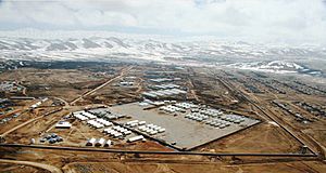
After the Taliban fell, the first Provincial Reconstruction Team (PRT) in Afghanistan was set up near Gardez in March 2003. This team was led by the US Army. PRTs help bring electricity, medical clinics, schools, and water to villages. There are now over 30 PRTs in Afghanistan. It is still a challenge to help remote villages because of ongoing security issues.
Famous People from Gardez
- Abu Sa'id Gardezi: A geographer and historian from the 11th century.
- Shah Gardez: A Sufi saint from the 11th century who settled in Multan, Pakistan.
- Mohammad Najibullah: He was the President of Afghanistan from 1987 to 1992.
- Khalaf ibn Ahmad: The last Saffarid Emir who died in Gardez in 1009.
|
See Also
 In Spanish: Gardez para niños
 | William M. Jackson |
 | Juan E. Gilbert |
 | Neil deGrasse Tyson |


