
Balochistan (Pakistan) facts for kids
Quick facts for kids
Balochistan
بلوچستان
|
|||
|---|---|---|---|

A Balochi woman traveling with her camel
|
|||
|
|||
.svg)
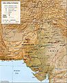
Location of Balochistan in Pakistan
|
|||

Map of Balochistan
|
|||
| Country | |||
| Established | 1 July 1972 | ||
| Area | |||
| • Total | 347,190 km2 (134,050 sq mi) | ||
| Population
(2011)
|
|||
| • Total | 7,914,000 | ||
| Time zone | UTC+05:00 (PST) | ||
| Official languages | Balochii · English | ||
| Website | Balochistan.gov.pk | ||


Balochistan (Urdu: صوبہ بلوچستان) is a large province in Pakistan. Its capital city is Quetta. About 10 million people live in Balochistan.
The province covers a huge area of 347,190 km2 (134,051 mi2). This means it makes up 45% of Pakistan's total land. Balochistan is bigger than the Republic of the Congo but smaller than Germany.
Balochistan became part of Pakistan in 1947. Before that, it was part of British India. On June 30, 1947, the local leader, the Khan of Kalat, decided to join Pakistan. Other tribal groups and the city of Quetta also agreed.
Later, in 1948, several small states in the area joined Pakistan. In 1970, these areas officially became the new Province of Balochistan. It is now a very important part of Pakistan.
Contents
How Balochistan Got Its Name
The people of Balochistan once called their land Moka or Maka. This word later became Makran. Some think Moka came from Mahi-khoran, which is Persian for "fish eaters." This name was used by people from the west for those living along the coast of Balochistan.
An ancient Greek writer named Arrian also called the people of this region ichythophagi. This is a Greek translation of "fish eaters."
In an old Sanskrit book from the 11th century, the land was called Baloksh. From Baloksh, the name changed and became Balochistan in Persian. The area is named after the many Baloch tribes. These tribes are an Iranian people who moved to the area around 1000 A.D.
Most people who live here are considered Balochi, even if they don't speak the Balochi language. Other languages spoken include Pashto, Persian, and Brahui. The southern part of Balochistan is known as Makran. The name Balochistan simply means "the land of the Baloch" in many local languages.
Exploring Balochistan's Geography

Balochistan is in the southwest of Pakistan. It covers a large area of 347,190 km2 (134,051 mi2). This makes it Pakistan's biggest province by land area. It covers 44% of the country's total land.
The province shares borders with Afghanistan to the north and northwest, and Iran to the southwest. To the east, it borders Pakistan's provinces of Punjab and Sindh. To the south, it meets the Arabian Sea.
Balochistan is located on the southeastern part of the Iranian plateau. Its special location means it connects different important regions. These include the Greater Middle East, Southwest Asia, Central Asia, and South-central Asia.
The province is also near the Strait of Hormuz. This strait is a very important sea route. Balochistan offers the shortest way from seaports to Central Asia. Because of its location, this region has been important for many empires throughout history.
Quetta, the capital city, is in the northeastern part of the province. It is in a river valley near the Bolan Pass. This pass has been a key route from the coast to Central Asia for a long time. Many historical groups, including the British, used this route to travel into Afghanistan.
Balochistan has many natural resources, like natural gas. It is the second largest supplier of natural gas in Pakistan. The province also has other resources that could be developed. People in Balochistan have lived in towns and used sustainable water sources for thousands of years.
How Balochistan is Governed
Balochistan has a government system similar to other provinces in Pakistan. It uses a parliamentary system. This means that the people elect representatives to make laws.
The ceremonial head of the province is the Governor. The Governor is chosen by the President of Pakistan. The main leader of the province is the Chief Minister. This person is usually the head of the largest political party or group in the provincial assembly.
The Provincial Assembly of Balochistan is a single-chamber legislature. It has 65 seats. Of these, 4% are set aside for people who are not Muslim. Also, 16% of the seats are only for women.
The laws are carried out by the Balochistan High Court. This court is in Quetta and is led by a Chief Justice. For managing the province, Balochistan is divided into 30 smaller areas called districts.
Provincial Symbols of Balochistan
| Provincial flag | Flag of Balochistan | |
|---|---|---|
| Provincial seal | Emblem of Balochistan | |
| Provincial animal | Camel |  |
| Provincial bird | MacQueen's bustard | |
| Provincial fish | Rohu | |
| Provincial insect | Tamarisk leaf beetle |  |
| Provincial tree | Silver date Palm | |
| Provincial flower | Wild tulip | |
| Provincial fruit | Peach | |
| Provincial dish | Sajji | |
| Provincial dance | Jhumar | |
| Provincial instrument | Suroz | |
| Provincial sport | Tent pegging |
Images for kids
-
This map shows the sites and size of the Indus Valley Civilisation. Important centers like Mohenjo-Daro and Mehrgarh were in what is now Balochistan. This area was the western edge of this ancient civilization.
-
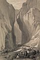
A historical drawing of Bolan Pass in Balochistan, Pakistan.
-
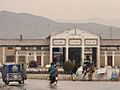
Quetta Railway Station.


See also
 In Spanish: Baluchistán (Pakistán) para niños
