
Quetta facts for kids
Quick facts for kids
Quetta
|
||
|---|---|---|
|
|
||
|
||
| Nickname(s):
Fruit Garden of Pakistan
|
||

Quetta
Location in Balochistan, Pakistan

Quetta
Location in Pakistan
|
||
| Country | ||
| Province | ||
| Division | Quetta | |
| District | Quetta | |
| Settled | 1876 | |
| Government | ||
| • Type | Municipal Corporation | |
| Area | ||
| • City | 3,501 km2 (1,352 sq mi) | |
| • Metro | 3,501 km2 (1,352 sq mi) | |
| Elevation | 1,680 m (5,510 ft) | |
| Population
(2023)
|
||
| • City | 1,565,546 | |
| • Rank | 9th in Pakistan; 1st in Balochistan |
|
| • Density | 447.17/km2 (1,158.17/sq mi) | |
| • Demonym | Quettan or Quettawal (kʰwətə.wal) | |
| Time zone | UTC+05:00 (PKT) | |
| Postal code |
87300
|
|
| Dialing code | 081 | |


Quetta is the capital and largest city of the Balochistan province in Pakistan. It is the ninth largest city in Pakistan. In 2024, its population was estimated to be over 1.5 million people.
Quetta is located in the southwest of Pakistan. It lies in a valley surrounded by tall mountains. At about 1,680 meters (5,510 feet) above sea level, it is Pakistan's highest major city. Quetta is often called the "Fruit Garden of Pakistan" because of its many fruit orchards. It produces a large variety of fresh and dried fruits.
The city is close to the Pakistan-Afghanistan border. This makes Quetta an important place for trade and communication between the two countries. It is also near the Bolan Pass, which was a main route from Central Asia to South Asia long ago.
Contents
What's in a Name?
The name Quetta comes from the Pashto word Kwatkōṭ or kōta. This word means "fortress." In the past, Quetta was known as Shalkot.
Quetta's Story
-
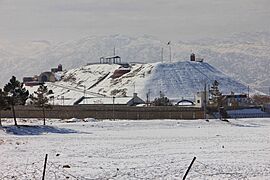
Quetta Fort Mirri
-
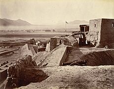
Fort Mirri in 1880
-
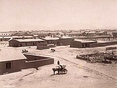
Quetta Cantonment, 1889


Early Times
Sultan Mahmud Ghaznavi captured the area that is now Quetta during his invasions of South Asia. Later, in 1543, the Mughal emperor Humayun visited Quetta on his way to Safavid Persia. He left his son, Akbar, who would also become a Mughal emperor, here.
By 1709, the region was part of the Afghan Hotak dynasty. It remained so until 1747, when Ahmed Shah Durrani took control. He made it part of the Durrani Empire. The first European to visit Quetta was in 1828. He described it as a "mud-walled fort surrounded by three hundred mud houses."
How Quetta Became a City

In 1876, the British took over Quetta. They made it part of British India. A British General named John Jacob had suggested this in 1856. He knew Quetta was important because of its location on the western border. British troops then built many buildings and roads for their army base.
The city was rebuilt after a big earthquake in 1935. This earthquake destroyed most of Quetta's buildings. About 40,000 people died. After Pakistan became a country, Balochistan became a province. Quetta then became its capital city.
Quetta's Weather
Quetta has a cold semi-arid climate. This means it has big differences between summer and winter temperatures. Summer starts in late May and lasts until early September. Average temperatures are around 24–26°C (75–79°F). The hottest temperature ever recorded was 42°C (108°F) on July 10, 1998.
Autumn is from mid-September to mid-November, with temperatures around 12–18°C (54–64°F). Winter begins in late November and ends in late February. Average temperatures are about 4–5°C (39–41°F). The coldest temperature ever recorded was -18.3°C (-0.9°F) on January 8, 1970. Spring is from early March to mid-May, with temperatures around 15°C (59°F).
Unlike other parts of Pakistan, Quetta does not have a heavy monsoon season. The most rain in 24 hours was 113 mm (4.4 in) on December 17, 2000. The most rain in one month was 232.4 mm (9.15 in) in March 1982. That year also had the highest yearly rainfall, 949.8 mm (37.39 in). Snowfall in winter can be unpredictable.
| Climate data for Quetta (1991-2020) | |||||||||||||
|---|---|---|---|---|---|---|---|---|---|---|---|---|---|
| Month | Jan | Feb | Mar | Apr | May | Jun | Jul | Aug | Sep | Oct | Nov | Dec | Year |
| Record high °C (°F) | 23.6 (74.5) |
26.7 (80.1) |
31.1 (88.0) |
35.0 (95.0) |
39.4 (102.9) |
41.5 (106.7) |
42.0 (107.6) |
40.6 (105.1) |
38.3 (100.9) |
34.0 (93.2) |
36.0 (96.8) |
25.0 (77.0) |
42.0 (107.6) |
| Mean daily maximum °C (°F) | 11.8 (53.2) |
14.0 (57.2) |
19.5 (67.1) |
25.9 (78.6) |
31.4 (88.5) |
35.5 (95.9) |
36.8 (98.2) |
35.4 (95.7) |
31.9 (89.4) |
26.0 (78.8) |
19.6 (67.3) |
14.6 (58.3) |
25.2 (77.4) |
| Daily mean °C (°F) | 4.8 (40.6) |
7.1 (44.8) |
12.5 (54.5) |
17.9 (64.2) |
23.0 (73.4) |
27.3 (81.1) |
29.2 (84.6) |
27.5 (81.5) |
22.8 (73.0) |
16.5 (61.7) |
11.0 (51.8) |
6.5 (43.7) |
17.2 (62.9) |
| Mean daily minimum °C (°F) | −1.9 (28.6) |
0.3 (32.5) |
5.1 (41.2) |
10.0 (50.0) |
14.6 (58.3) |
19.0 (66.2) |
21.6 (70.9) |
19.7 (67.5) |
13.6 (56.5) |
7.0 (44.6) |
1.9 (35.4) |
−1.4 (29.5) |
9.1 (48.4) |
| Record low °C (°F) | −18.3 (−0.9) |
−16.7 (1.9) |
−8.3 (17.1) |
−3.9 (25.0) |
−0.3 (31.5) |
5.0 (41.0) |
8.9 (48.0) |
3.3 (37.9) |
−0.6 (30.9) |
−8.3 (17.1) |
−13.3 (8.1) |
−18.3 (−0.9) |
−18.3 (−0.9) |
| Average precipitation mm (inches) | 55.0 (2.17) |
58.4 (2.30) |
49.5 (1.95) |
40.0 (1.57) |
17.8 (0.70) |
3.2 (0.13) |
8.8 (0.35) |
4.9 (0.19) |
4.2 (0.17) |
4.5 (0.18) |
19.3 (0.76) |
34.6 (1.36) |
300.2 (11.83) |
| Average snowfall cm (inches) | 22 (8.7) |
17 (6.6) |
3.0 (1.2) |
0 (0) |
0 (0) |
0 (0) |
0 (0) |
0 (0) |
0 (0) |
0 (0) |
0.51 (0.2) |
14 (5.4) |
56.51 (22.1) |
| Average precipitation days (≥ 1.0 mm) | 5.0 | 5.7 | 5.4 | 4.1 | 1.7 | 0.7 | 0.8 | 0.8 | 0.4 | 0.6 | 1.7 | 2.7 | 29.6 |
| Mean monthly sunshine hours | 220.1 | 209.05 | 232.5 | 273.0 | 334.8 | 327.0 | 313.1 | 313.1 | 294.0 | 306.9 | 279.0 | 238.7 | 3,341.25 |
| Source 1: NOAA, Hong Kong Observatory (altitude: 1589 m) (only snow inch, sun) | |||||||||||||
| Source 2: PMD | |||||||||||||
From 1999 to 2001, Quetta had a serious drought. There was no snowfall and less rain than usual. In 2002, the city saw snow again after five years. In 2008, it snowed 10 cm (4 in) in four hours on January 29. Then, on February 2, it snowed 25.4 cm (10 in) in 10 hours. This was the heaviest snowfall in ten years.
People of Quetta
| Historical population | ||
|---|---|---|
| Year | Pop. | ±% |
| 1941 | 65,000 | — |
| 1951 | 84,000 | +29.2% |
| 1961 | 107,000 | +27.4% |
| 1972 | 158,000 | +47.7% |
| 1981 | 286,000 | +81.0% |
| 1998 | 565,137 | +97.6% |
| 2017 | 1,001,205 | +77.2% |
| 2023 | 1,565,546 | +56.4% |
According to the 2023 Census, Quetta's population was 1,565,546 people. This makes it the largest city in Balochistan province. It is also one of Pakistan's major cities. Quetta has many different ethnic groups. The largest group is Pashtun, followed by Balochs, Hazaras, Brahui, Punjabis, and Muhajir people.
Urdu is Pakistan's national language. Everyone in Quetta understands and uses it. It helps people from different groups communicate. Some reports say that about 500,000 to 600,000 Hazaras live in Quetta and nearby areas.
| Religious group |
1941 | 2017 | ||
|---|---|---|---|---|
| Pop. | % | Pop. | % | |
| Islam |
27,935 | 43.33% | 975,815 | 97.64% |
| Hinduism |
24,010 | 37.24% | 6,112 | 0.61% |
| Sikhism |
7,364 | 11.42% | N/A | N/A |
| Christianity |
5,024 | 7.79% | 16,842 | 1.69% |
| Zoroastrianism |
73 | 0.11% | N/A | N/A |
| Buddhism |
42 | 0.07% | N/A | N/A |
| Judaism |
11 | 0.02% | N/A | N/A |
| Jainism |
6 | 0.01% | N/A | N/A |
| Ahmadiyya |
N/A | N/A | 363 | 0.04% |
| Others | 11 | 0.02% | 253 | 0.03% |
| Total population | 64,476 | 100% | 999,385 | 100% |
How Quetta is Run
Quetta is governed by a municipal corporation. This group has 66 members who are elected from different areas of the city. These members then choose a mayor and a deputy mayor. The Quetta Development Authority also helps by providing services for the city.
Getting Around Quetta


Quetta is on the western side of Pakistan. It is connected to the rest of the country by roads, railways, and an international airport. The airport is close to the city center.
Air Travel
Quetta International Airport is the second highest airport in Pakistan. It is about 1,605 meters (5,266 feet) above sea level. Pakistan International Airlines has regular flights. You can fly to and from other major Pakistani cities like Islamabad, Gwadar, Karachi, Lahore, and Peshawar.
Train Travel
Quetta Railway Station is one of the highest railway stations in Pakistan. It is about 1,676 meters (5,499 feet) above sea level. The railway tracks were built in the 1890s during the British era. They connected Quetta to the rest of the country.
The large network of Pakistan Railways links Quetta to Karachi in the south. This track is 863 km (536 miles) long. It also connects to Lahore in the northeast (1,170 km or 727 miles) and Peshawar even further northeast (1,587 km or 986 miles). A paved road runs next to the railway. This road connects Quetta to Karachi through towns like Sibi, Jacobabad, and Rohri.
Learning in Quetta
Quetta is an important learning center for the Balochistan province. The city has many government and private colleges. Here are some of them:
- Balochistan Agriculture College
- Balochistan University of Information Technology, Engineering and Management Sciences (BUITEMS)
- Bolan Medical College
- Islamia High School, Quetta: Quaid-e-Azam often visited this school in 1937. He called it Chhota Aligarh (Little Aligarh).
- Pakistan Command and Staff College
- Sardar Bahadur Khan Women's University
- St Francis Grammar School
- St. Joseph's Convent School, Quetta
- Government Science College, Quetta
- Tameer-e-Nau Public College
- University Law College, Quetta
- University of Balochistan
Sports in Quetta

Football is the most popular sport in Quetta. The city has produced famous footballers for the Pakistan national football team. These include Abdul Wahid Durrani, Qayyum Changezi, Ayub Dar, Mohammad Ali, and Rajab Ali Hazara. Some main football clubs from Quetta are Baloch Quetta. The Balochistan United WFC team won the 2014 National Women Championship in 2014.
The main football ground is Ayub National Stadium. This stadium is also used for other sports like athletics. Other football grounds include Qayyum Papa Stadium and Sadiq Shaheed Stadium.

Bugti Stadium is the home ground for the Balochistan cricket team. This team plays in national cricket tournaments. The Quetta-based team Quetta Gladiators plays in the Pakistan Super League (PSL). They won the PSL in 2019.
Boxing is also very popular in Quetta. Muhammad Waseem is a professional boxer from the city. In bodybuilding, Nisar Ahmed Khilji has won "Mr. Balochistan" and "Mr. Pakistan" titles. He has also represented Pakistan in international bodybuilding contests. In hockey, Quetta has produced players like Zeeshan Ashraf and Shakeel Abbasi. They were both members of the Pakistan's national hockey team.
Sports Facilities

Quetta has local facilities for mountain climbing and caving. There are also places for water sports. Hayatullah Khan Durrani is the chief executive of the Hayat Durrani Water Sports Academy. This is Balochistan's first and only academy for rowing, canoeing, kayaking, sailing, rough swimming, and boating. All these activities are offered for free to young members at Hanna Lake.
Images for kids
-
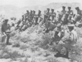
Junior officers in a tactical discussion at the Infantry School, Quetta
-
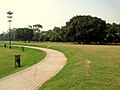
Askari Park
-
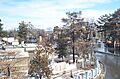
Jinnah Road
-
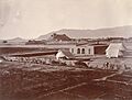
Quetta in 1880


See also
 In Spanish: Quetta para niños
