
Bolan Pass facts for kids
Quick facts for kids Bolān Passدرۂ بولان |
|
|---|---|

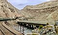
A railway track traverses the pass
|
|
| Elevation | 1,793.4 m (5,884 ft) |
| Traversed by | |
| Location | Balochistan, Pakistan |
| Range | Toba Kakar range |
| Coordinates | 29°27′13″N 67°29′41″E / 29.453516°N 67.494648°E |

Bolan Pass
Location in Pakistan

Bolan Pass
Location in Balochistan, Pakistan
|
|
The Bolān Pass (Urdu: درۂ بولان) is a famous mountain pass in Balochistan, a province in western Pakistan. It cuts through the Toba Kakar mountain range. This pass is about 120 kilometers (75 miles) from the Afghanistan border.
The Bolan Pass is an 89-kilometer (55-mile) long section of the Bolan river valley. It stretches from Rindli in the south to Darwāza in the north. The pass has many narrow valleys and rocky sections called gorges. It connects the cities of Sibi and Quetta by both road and railway.
This pass is very important because of its location. For a long time, it has been a main route for traders, travelers, and armies. It connects different parts of South Asia. The Bolan Pass is a key gateway on the border of Balochistan. It links Jacobabad and Sibi with Quetta.
The people living south of the pass are mostly Brahvi tribes. They live from the Bolan Pass all the way to Cape Monze by the Arabian Sea. North of the pass, you'll find mainly Pashtuns. To the west, the Baloch people live.
The Bolan Pass is part of the Toba Kakar range. This range is south of the Hindu Kush mountains. The pass is known for its many deep valleys and gorges. The mountains of the Bolan Pass form a natural border. This border is between the Indian plate and the Iranian plateau. The southern end of the pass, near Dhadar, is the western edge of the Indus Valley. It is a very important spot connecting Pakistan, Afghanistan, Iran, and the Arabian Sea.
History of the Bolan Pass


The Bolan Pass is like the Khyber Pass, but in the south. Both passes have been used for centuries by different groups entering the Indian subcontinent. For example, in 1748, the Afghan king Ahmad Shah Durrani used the Bolan Pass to enter India. His capital, Qandahar, was close to the pass, making it easy to reach Indian lands.
In 1837, there was a worry that Russia might invade South Asia. They could use the Khyber and Bolan Passes. So, the British sent a representative to Kabul to get help from the local ruler, Dost Mohammed. In February 1839, during the First Anglo-Afghan War, the British Army used the Bolan Pass. Sir John Keane led 12,000 soldiers through it. They went on to capture Qandahar and later Ghazni. The pass they used was a bit different from the modern railway route.
Later, in 1883, Sir Robert Groves Sandeman made a deal with the Khan of Kalat, Khudadad Khan. The British gained control over the pass. In return, they paid an annual fee to the Khan.
The Bolan Pass Railway
.jpg)
The railway line from Sibi first went along the Bolan river. But floods often damaged this part of the track. So, the railway was moved. Now, it follows the Mashkaf valley and then joins the Bolan route near Machh.
There is also another railway route from Sibi to Quetta. This one goes through the Harnai valley. It is longer than the Bolan route. However, the Harnai route is used for most regular train traffic. The Bolan route is kept for emergencies.
Along the Bolan route, at the Khundilani gorge, the valley is surrounded by huge cliffs. These cliffs are about 800 feet (240 meters) high. At Siri Bolān, the path between the rocks is so narrow that only a few people can walk side-by-side.
The weather in the pass can be very extreme. In summer, it gets very hot. In winter, near the top, it becomes extremely cold. The strong, icy wind rushing through the narrow pass can be very dangerous. Since 1877, the British Indian Army helped keep the pass safe. They protected it from local Baluch tribesmen, especially the Marris.
Images for kids
-
A railway track traverses the pass
See also
 In Spanish: Paso de Bolán para niños
