
Iranian plateau facts for kids

The Iranian Plateau, also known as the Persian Plateau, is a very large land area. It is a special geological feature found in Southwest Asia, Southern Asia, and the Caucasus region. Historically, this area was home to important ancient kingdoms like Parthia, Media, and eastern Persia. These were the main parts, or heartlands, of a larger region called Greater Persia. Today, this mostly includes the countries of Iran, Afghanistan, and Pakistan (west of the River Indus).
Contents
What is a Plateau?
A plateau is like a large, flat tableland that is much higher than the land around it. Think of it as a big, elevated plain. Plateaus often have steep sides. They can be formed in different ways, such as by volcanic activity or by the slow movement of Earth's tectonic plates. The Iranian Plateau is a great example of a large plateau formed by these powerful geological forces.
Where is the Iranian Plateau Located?
The Iranian Plateau stretches across a vast area. It covers much of Iran, Afghanistan, and parts of Pakistan. It is bordered by several mountain ranges. To the north, you'll find the Elburz Mountains and the Caucasus Mountains. To the west, there are the Zagros Mountains. These mountains help define the edges of this huge plateau. The plateau is also close to important bodies of water like the Persian Gulf and the Caspian Sea.
Size and Importance
The Iranian Plateau is one of the largest plateaus in the world. It covers an area of about 3.7 million square kilometers (about 1.4 million square miles). This makes it a very significant geographical feature. Because of its size and location, it has played a big role in history. Many ancient civilizations and empires rose and fell on this plateau. It was a crossroads for trade and culture between East and West for thousands of years.
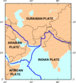
Geological Activity
The Iranian Plateau is an active geological area. It sits near the boundaries where several of Earth's huge tectonic plates meet. Specifically, it is close to where the Eurasian Plate and the Arabian Plate are pushing against each other. The Indian Plate also plays a role in the region's geology. This constant pushing and grinding of plates causes a lot of geological activity. This is why the region experiences earthquakes. Scientists study these movements to understand how the Earth's surface changes over time.
Climate and Landscape
The climate on the Iranian Plateau varies a lot. In many parts, it is very dry, with large deserts. These deserts can have extreme temperatures, very hot in summer and cold in winter. However, there are also mountainous areas that receive more rainfall or snow. These areas can have forests and grasslands. Rivers flowing from the mountains create fertile valleys where people can farm. The diverse landscape includes high peaks, vast plains, and salt lakes.
History and Culture
For thousands of years, the Iranian Plateau has been home to many different peoples and cultures. It was the birthplace of powerful empires, such as the Achaemenid Empire (also known as the First Persian Empire). These empires built impressive cities, developed advanced systems of government, and created beautiful art and architecture. The plateau's geography influenced how these societies developed. The mountains provided natural defenses, and the fertile valleys supported agriculture. Today, the region continues to be rich in history and cultural heritage.
Images for kids
-
Location of the Iranian plateau near the boundaries between the Eurasian Plate and the Arabian/Indian plates

See also
 In Spanish: Meseta iraní para niños
