Qalati Ghilji facts for kids
Quick facts for kids
Qalat
|
|
|---|---|
|
City
|
|

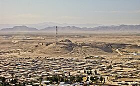
The historical citadel in Qalat
|
|
| Country | |
| Province | Zabul Province |
| District | Qalat |
| Government | |
| • Type | Municipality |
| Elevation | 5,090 ft (1,550 m) |
| Population
(2015)
|
|
| • Urban | 49,158 |
| • Metro | 9,900 |
| Time zone | UTC+4:30 (AFT) |
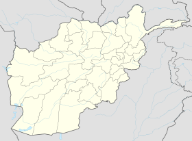
Qalat, also known as Kalat, is an important city in southern Afghanistan. It is the capital of Zabul Province. The city is connected to other major cities like Kandahar and Ghazni by Highway 1.
In 2014, Qalat had about 5,462 homes. Around 49,158 people lived there. The city is divided into at least four police districts. Much of the land in Qalat is open or unused. However, about 19% of the land is built up. A large part of this built-up area is used for public buildings. Qalat also has two areas set aside for industries.
The Qalat Airport is just a few miles north of the city. Near the airport, there used to be a special team called the Provincial Reconstruction Team Zabul, built by the United States. In August 2021, the Taliban took control of Qalat. This made it the seventeenth provincial capital they captured during their 2021 offensive.
Contents
Qalat's Past: A Look at History
In ancient times, the area around Qalat was home to the Khalaj tribe. A famous ruling family in India, the Khalji dynasty, came from this city. This tribe later became known as the Ghilji tribe of Pashtuns.
In 1857, a group of British officials visited Qalat. They were on their way to Kandahar to make a new friendship agreement. The city welcomed them warmly. They even held a meeting to discuss important matters.
Later, in 1867, a leader named Sher Ali Khan captured Qalat. It was a tough battle. Sadly, his son, Mahmud Ali, and his uncle both died during the fighting.
Qalat in the 21st Century
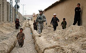
To help Qalat grow, the first airstrip in Zabul province was built near the city in 2006. It was a simple dirt runway. The first flight brought supplies for groups working to rebuild the area.
Three years later, a school for girls was built to improve education. They received school supplies and prayer mats. More books and supplies were given regularly until 2013. Programs also helped bring clean water to the city. In 2009, the water system at the old Qalat City Hospital was improved. This gave patients access to clean drinking water.
However, not all rebuilding efforts worked out. In 2006, work began on a new business area. It was meant to be a place for shops and development. But after spending ten million dollars and three years, most buildings were empty. They were either hard to keep up or not needed. The governor even refused to move into a new house there, saying it wasn't safe.
Qalat's Weather: Understanding the Climate
Qalat has a semi-arid climate. This means it's usually dry, but it gets some rain. The average temperature in Qalat is about 13.6 °C (56.5 °F). The city gets about 283 mm (11 inches) of rain each year.
July is the warmest month, with an average temperature of 27.5 °C (81.5 °F). January is the coldest month, with an average temperature of -2.9 °C (26.8 °F).
| Climate data for Qalat | |||||||||||||
|---|---|---|---|---|---|---|---|---|---|---|---|---|---|
| Month | Jan | Feb | Mar | Apr | May | Jun | Jul | Aug | Sep | Oct | Nov | Dec | Year |
| Mean daily maximum °C (°F) | 7.7 (45.9) |
8.8 (47.8) |
15.9 (60.6) |
23.3 (73.9) |
30.0 (86.0) |
33.7 (92.7) |
35.1 (95.2) |
33.6 (92.5) |
29.6 (85.3) |
23.4 (74.1) |
15.7 (60.3) |
10.6 (51.1) |
22.3 (72.1) |
| Daily mean °C (°F) | 2.3 (36.1) |
3.3 (37.9) |
9.9 (49.8) |
16.9 (62.4) |
23.5 (74.3) |
27.2 (81.0) |
28.8 (83.8) |
27.3 (81.1) |
23.1 (73.6) |
17.1 (62.8) |
9.7 (49.5) |
4.6 (40.3) |
16.1 (61.0) |
| Mean daily minimum °C (°F) | −3.3 (26.1) |
−2.5 (27.5) |
2.9 (37.2) |
8.8 (47.8) |
14.8 (58.6) |
18.4 (65.1) |
20.9 (69.6) |
19.8 (67.6) |
15.9 (60.6) |
10.3 (50.5) |
3.4 (38.1) |
−1.3 (29.7) |
9.0 (48.2) |
| Average precipitation mm (inches) | 60 (2.4) |
81 (3.2) |
68 (2.7) |
30 (1.2) |
3 (0.1) |
2 (0.1) |
5 (0.2) |
2 (0.1) |
1 (0.0) |
2 (0.1) |
14 (0.6) |
33 (1.3) |
301 (12) |
| Average relative humidity (%) | 58 | 64 | 50 | 32 | 17 | 14 | 17 | 16 | 15 | 20 | 39 | 49 | 33 |
| Mean daily sunshine hours | 7.5 | 7.6 | 9.7 | 11.3 | 12.4 | 12.7 | 12.6 | 11.9 | 11.1 | 10.2 | 8.9 | 8.3 | 10.4 |
| Source: Climate-Data.org | |||||||||||||
Qalat's People: Demographics
The population of Qalat is about 49,158 people. The entire Zabul province has around 700,000 residents.
Qalat's Economy: How People Make a Living
Most people in Qalat earn money through farming, trading goods, and transportation. The Tori Dam is located on the Tarnak River near the city. This dam helps with water for farming and other uses.
Sports in Qalat
Cricket and association football (soccer) are the most popular sports in Qalat. The Afghanistan Cricket Board is even building a cricket stadium in the city.
Famous Places to See in Qalat
- The city's skyline is known for a strong fortress. It was built by the forces of Alexander the Great. You can learn more about it at Qalat (fortress).
- Ghar Bolan Baba is a very deep cave, about 730 meters (2,400 feet) deep. In the past, people used it for religious purposes.
 | Toni Morrison |
 | Barack Obama |
 | Martin Luther King Jr. |
 | Ralph Bunche |


