
Emanuel Bowen facts for kids

Emanuel Bowen (born in 1694, died on May 8, 1767) was a Welsh mapmaker. He was very special because he became the official mapmaker for two kings: King George II of Great Britain and Louis XV of France. People at the time thought Bowen was excellent. He made some of the biggest, most detailed, and most accurate maps of his time. He often worked with other famous mapmakers like John Owen and Herman Moll.
Contents
About Emanuel Bowen

Emanuel Bowen was born in a place called Tal-y-Llychau, which is now known as Talley, in Carmarthenshire, Wales. His father, Owen Bowen, was an important person in the area, part of the local gentry. This means his family was well-known and respected, even if they weren't royalty.
When Emanuel was about 15 years old, in 1709, he started learning a trade. He became an apprentice to Charles Price, who was a merchant tailor. An apprentice learns a skill by working for an expert. Bowen moved to London in 1714 and officially joined the Merchant Taylors Company in 1716. This company was like a guild for tailors and merchants.
Bowen's Mapmaking Career

One of Bowen's first big projects was a book called Britannia Depicta, published in 1720. This book had over 200 road maps. It also included small maps of every county in England and Wales. This book was special because the maps were printed on both sides of each page, making it a smaller, easier-to-carry book.
By 1726, Bowen was known as one of the best map engravers in London. He taught many young people how to make maps. Some of his most famous students were Thomas Kitchin, Thomas Jeffreys, and John Lodge. His own son, Thomas Bowen, also became a mapmaker.
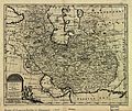
Emanuel Bowen published many important map collections. These included "A Complete System of Geography" (1744–1747) and a "Complete Atlas" (1752). He also made "Atlas Minimus," which was a set of small pocket maps in 1758. He created many individual maps of English counties, Germany, and other parts of the world.
Bowen loved to add small notes and details to his maps. He would fill empty spaces with interesting facts about history or the land. This made his maps not just useful, but also fun to read.
Later Life and Legacy
Even though Emanuel Bowen was famous and worked for kings, he died without much money. This was common for many mapmakers back then. His son, Thomas Bowen, continued the family business. Sadly, Thomas also faced money problems and died in a workhouse in 1790. A workhouse was a place where poor people could live and work.
Mapping the Southern Continent

One of Bowen's interesting maps was called A Complete Map of the Southern Continent. This map showed a large landmass in the Southern Hemisphere. It was based on earlier maps, especially one by Melchisédech Thévenot from 1663.
Thévenot's map was very similar to a map by Joan Blaeu from 1659. Blaeu's map was even set into the floor of the Amsterdam Town Hall! These maps showed a land called Hollandia Nova (New Holland) in the west and Terra Australis (Southern Land) in the east. This division was shown by a line on the map.
Map Details and Claims
Bowen's map clearly showed the separation between Hollandia Nova and Terra Australis. This was important later on. When Britain started the colony of New South Wales in 1788, they claimed all the land in Australia east of that dividing line. This line was at 135° East of Greenwich, just as shown on Bowen's map.
Major Works by Emanuel Bowen
- Around 1714: Maps of the Continents.
- 1720 (with John Owen): Britannia Depicta or Ogilby Improved.
- 1744–1747: A Complete System of Geography.
- 1744–1748: Maps for Complete Collection of Voyages (Harris).
- 1752: Complete Atlas Distinct View of the Known World.
- 1755–1760 (with Thomas Kitchin): The Large English Atlas (with later editions).
- 1758 (with John Gibson): Atlas Minimus (re-issued later).
- 1762 (with Thomas Kitchin): The Royal English Atlas (re-issued later).
- Around 1763 (with Benjamin Martin): The Natural History of England.
- 1766: Universal History of the World.
- 1767 (with Thomas Bowen): Atlas Anglicanus (re-issued later).
- Around 1777 (Thomas Bowen): The World showing the Discoveries of Captain Cook and other Circumnavigators.
- Around 1784 (Thomas Bowen): Maps in Rapkins's History of England.
- A Complete map of the Southern Continent survey'd by Capt. Abel Tasman & depicted by order of the East India Company in Holland in the Stadt House at Amsterdam; E. Bowen, Sculpt.
Images for kids
-
A New & Accurate Map of Persia drawn by Emanuel Bowen in 1747
_Empire_1747.jpg)
