
Herman Moll facts for kids
Herman Moll was a famous British mapmaker, engraver, and publisher. He was born in the mid-1600s, possibly in Germany or the Netherlands, and he died on September 22, 1732. He became well-known for creating many detailed maps and globes that helped people understand the world better.

Contents
Herman Moll's Early Life and Work
We don't know exactly when or where Herman Moll was born, but it was likely in the mid-1600s in either Germany or the Netherlands. The first time anyone wrote about him was in 1678. A scientist named Robert Hooke noted that Moll was working in London as an engraver. An engraver is someone who carves designs or words onto metal plates, which can then be used to print images.
Moll soon focused on engraving maps. He learned by studying the work of other mapmakers. Eventually, he started making his own maps and globes.
Becoming a Famous Mapmaker
Starting His Business in London
Herman Moll probably started by selling his first maps from a small stall in different parts of London. By 1688, he had his own shop in an area of London called Blackfriars. Over the years, his business moved a few times. He finally settled near the River Thames, where he stayed until he died.
In the 1690s, Moll mostly worked for other map publishers, engraving maps for them. But in the early 1700s, he began to create and engrave maps all by himself, under his own name.
Moll's Independent Publishing Career


In 1701, Moll helped publish a big book called A System of Geography. This book was full of maps that Moll had engraved. It was so popular that many people started calling it "Moll's Geography."
After that, he published several other important works. One was Fifty-six new and accurate maps of Great Britain, which was a book of maps of the British Isles. From 1707 to 1717, he worked on a huge project called Atlas Geographus. This was released in parts every month and eventually became five large books. It showed the whole world with colorful maps and pictures. Like his other works, the Atlas Geographus was very popular, and many people copied his ideas.
In 1710, Moll started making clever small globes that fit in your pocket. These were special because they came in pairs: a bigger globe of the stars that opened up to show a smaller globe of the Earth inside. On the Earth globe, he often showed the route of William Dampier's trip around the world. These pocket globes are very hard to find today.
In 1715, Moll released The World Described, a collection of 30 large maps printed on both sides. These maps showed off Moll's amazing skill as an engraver. They were sold separately and later put together into atlases by a group of publishers working together.
This collection included two of Moll's most famous maps: A new and exact map of the dominions of the King of Great Britain and To The Right Honorable John Lord Sommers...This Map of North America According To Ye Newest and Most Exact Observations. These maps were special because they had very fancy decorated boxes and pictures, called cartouches, around the titles and explanations. They are known as the Beaver Map and the Codfish Map. Moll often used his maps to show and support Britain's ideas and claims to land around the world.
The Codfish Map, for example, shows a scene of people fishing for cod near Newfoundland. Since the early 1500s, cod fishing there was very important for the countries that had colonies in North America. When Moll made this map, arguments over fishing rights were a big problem between France and England in North America. By showing how fresh cod was prepared for shipping to Europe, Moll highlighted how important this industry was for his home country, England.
Moll even labeled the Atlantic Ocean as the "Sea of the British Empire." He emphasized Britain's right to fish off the coast of Newfoundland. On another map of the West Indies, he wrote "Spanish Fort Deserted" and "Good Ground" in a part of Carolina. On many of his North American maps, including the Beaver Map, he made sure to show important ports and roads. He knew that good roads and ports were important for Britain to become even stronger.
One expert, Pritchard, says that the Beaver Map was "one of the first and most important map documents about the ongoing argument between France and Great Britain over the borders of their American colonies." He adds that "The map was the main way Britain showed its position right after the Treaty of Utrecht in 1713."
Even other countries tried to use Moll's maps to support their own claims. For example, a map of Newfoundland Moll published in the 1680s showed a place called Pointe Riche at a certain latitude. In 1763, the French tried to use this map to claim the west coast of Newfoundland and Labrador. However, British officials like Governor Hugh Palliser and Captain James Cook found proof that Moll's map was not quite right about that location. In 1764, the French accepted the correct location of Pointe Riche.
No matter the political reasons, Moll's maps were very popular during his lifetime and after. Many of them still exist today, and they are considered beautiful and important works in the history of cartography (the study of mapmaking).
People Moll Worked With

Herman Moll worked with many important people during his life. These included the scientist Robert Hooke, the historian William Stukeley, and the explorer William Dampier. For Dampier, Moll engraved many maps that appeared in Dampier's popular books about his trips around the world.
Moll's road maps of England and Scotland were first published on their own. Later, they were added to new editions of Daniel Defoe's famous book, A Tour Thro' the Whole Island of Great Britain.
Another famous person who mentioned Moll was the writer Jonathan Swift. In his book Gulliver's Travels, the main character, Lemuel Gulliver, says that he told his "worthy friend, Mr. Herman Moll" that maps showed Australia too far to the east. This shows how well-known Moll was at the time!
However, except for Stukeley and Hooke, there isn't much proof that Moll knew these other famous people personally.
Moll's Death
Herman Moll passed away on September 22, 1732. His death was noted in a magazine called The Gentleman's Magazine.
Selected Works by Herman Moll
- Thesaurus Geographicus. A new body of geography: or a compleat description of the Earth Collected with great care from the most approv'd geographers and modern travellers and discoveries by several hands (1695)
- A System of Geography (1701)
- The Compleat Geographer (1709)
- The British empire in America (1708)
- A View of the Coasts, Countries, and Islands within the limits of the South Sea Company (1711)
- The World Described (1715)
- A Set of Fifty New and Correct Maps of England and Wales (1724)
- A Tour Thro' the Whole Island of Great Britain: Divided Into Circuits or Journies 4 volumes. (1761)
Images for kids
-
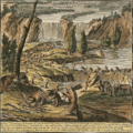
Inset of Moll's so-called Beaver Map from The World Described, a scene he copied from a map by Nicolas de Fer
-
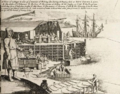
Inset of Moll's so-called Codfish Map from The World Described
-
Moll's A New & Exact Map of the Coast, Countries and Islands within ye Limits of ye South Sea Company London 1711 (1720)
-
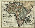
Moll's Africa, 1701
-
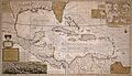
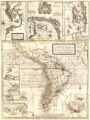
Moll's Map of the West-Indies or the Islands of America in the North Sea, circa 1715


.jpg)

