Thomas Bowen (engraver) facts for kids
Thomas Bowen was a Welsh artist who lived a long time ago, in the 1700s. He was an expert at making detailed maps and charts by engraving them. Engraving is a special way of carving designs onto metal plates, which can then be used to print many copies.
Thomas Bowen was the son of another famous map engraver named Emanuel Bowen. His father was so good at making maps that he even worked for kings, like King George II of England and King Louis XV of France! Thomas Bowen passed away in 1790.
Thomas Bowen's Amazing Maps
Thomas Bowen created many important maps and charts during his life. These maps helped people understand the world better, especially for travel and exploration.
- He engraved maps and charts of the West Indies. These were made for the government using surveys done by Captain James Speer.
- Around 1750, he made maps showing the area about twenty miles around London. He also created a map of the road between London and a place called St. David's.
- In 1776, he created a "New Projection of the Eastern and Western Hemispheres of the Earth." Hemispheres are the two halves of the Earth, like the top and bottom or left and right sides.
- In 1778, he made an "Accurate Map of the Russian Empire in Europe and Asia." This map showed the huge country of Russia.
- He also engraved a map called "A New & Accurate Map Of Europe From The Latest Improvements And Regulated By Astronomical Observations." This map was made for a book called Mountague's History of England.
- In 1780, he created an "English map of Persia and the Garden of Eden."
- Thomas Bowen also helped with a project by George Taylor and Andrew Skinner in 1776. This project was about surveying and mapping the roads in North Britain.

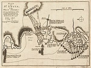
This is one of Thomas Bowen's engravings, showing the Battle of St Lucia in December 1778.
Black History Month on Kiddle
Famous African-American Artists:
 | Delilah Pierce |
 | Gordon Parks |
 | Augusta Savage |
 | Charles Ethan Porter |

All content from Kiddle encyclopedia articles (including the article images and facts) can be freely used under Attribution-ShareAlike license, unless stated otherwise. Cite this article:
Thomas Bowen (engraver) Facts for Kids. Kiddle Encyclopedia.
