
Merv facts for kids
|
مرو
Marw |
|

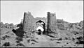
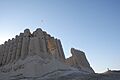
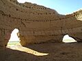
Ruins of the city of Merv: the Great Kyz Kala.
|
|

Location in West and Central Asia

Location in Turkmenistan
|
|
| Alternative name | Alexandria Antiochia in Margiana Marw al-Shāhijān |
|---|---|
| Region | Central Asia |
| Coordinates | 37°39′46″N 62°11′33″E / 37.66278°N 62.19250°E |
| Type | Settlement |
| History | |
| Cultures | Persian, Buddhist, Arab, Seljuk, Mongol, Turkmen |
| Site notes | |
| Condition | In ruins |
| Official name | State Historical and Cultural Park "Ancient Merv" |
| Type | Cultural |
| Criteria | ii, iii |
| Designated | 1999 (23rd session) |
| Reference no. | 886 |
| Region | Asia-Pacific |
Merv (Turkmen: Merw) was a very important city in Central Asia. It was located on the famous Silk Road, a network of trade routes. Today, its ruins are near the city of Mary, Turkmenistan. People lived in Merv from about 3000 BC until the 1700s AD.
Over time, many different empires ruled Merv. These included the Persians, Macedonians, Seleucids, Parthians, Sasanians, Arabs, Ghaznavids, Seljuqs, Khwarazmians, and Timurids.
Merv was the capital city for several powerful groups. In the early 800s, it was even the capital of the entire Islamic caliphate. Later, in the 1000s and 1100s, Merv became the capital of the Great Seljuk Empire. During this time, it was a major center for Islamic science and culture. Many famous poets, doctors, mathematicians, and astronomers lived and worked there. The great Persian thinker Omar Khayyam spent years at Merv's observatory.
Merv was also a holy place for several religions. In Zoroastrianism, it was one of 16 perfect lands created by their god. Between the 400s and 1000s, it was an important center for East Syrian Christians. A descendant of the Islamic prophet Muhammad, Ali ar-Ridha, lived in Merv for several years.
In the 1100s and 1200s, Merv might have been the world's largest city. It had a population of up to 500,000 people. People called it "Merv the Great" and the "capital of the eastern Islamic world." In 1221, the city was attacked by the Mongols. This led to massive destruction. Many historical records say that almost everyone in the city was killed. After this, Merv was partly rebuilt but never became as grand as before. In the late 1700s, the city was destroyed one last time. Its people were moved away. By the 1800s, the area around Merv was empty.
Today, the Government of Turkmenistan protects the site as the State Historical and Cultural Park "Ancient Merv." It is a UNESCO World Heritage Site. This means it is a very important place for everyone to preserve.
Contents
Exploring Merv's Past
.jpg)
Merv has a very long history. Archaeologists have found signs of village life from as far back as 3000 BC. The ancient texts of Zoroastrianism mention Merv as Mouru, one of 16 perfect lands.
Under the Achaemenid Empire (around 550–330 BC), Merv was an important place. It was called Margu in ancient Persian writings. The first city of Merv was built in the 500s BC as the Persian Empire grew.
Greek Influence

While Alexander the Great might not have visited Merv, the city was named Alexandria after him for a while. After his death, it became the capital of the Margiana region. It was ruled by the Seleucids, Greco-Bactrians, Parthians, and Sasanians.
A Seleucid ruler named Antiochus Soter (who ruled from 281–261 BC) renamed it Antiochia Margiana. He rebuilt and made the city bigger. This area is now known as the Gyaur Gala fortress.
Parthian and Sasanian Times
After the Seleucid rule ended, the Parthians and Kushans took control. Around 53 BC, about 10,000 Roman prisoners of war were brought to Merv.
Merv was a major center for Buddhist learning for many centuries. There were Buddhist temples and stupas (dome-shaped buildings for worship). This continued until Islam became the main religion.
.jpg)
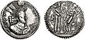
When the Sasanian ruler Ardashir I took Merv (around 220–240 AD), the city began minting its own coins. These coins show that the Sasanians ruled Merv for almost 400 years. During this time, Merv was home to many religions. These included Zoroastrianism (the official Sasanian religion), Buddhism, Manichaeism, and Christianity.
Arab Conquest and Golden Age
.jpg)
Sasanian rule ended when the last Sasanian ruler was killed near Merv. The Arab army then took over the city. Merv became the capital of the Umayyad province of Khorasan. In 671, 50,000 Arab troops settled in Merv. From here, Arab leaders brought large parts of Central Asia under their control. Merv became one of the first Persian-speaking areas to become mostly Muslim.
Merv became very important again in 748. An Iranian general named Abu Muslim started a new Abbasid dynasty from Merv. He used the city as a base to fight against the Umayyad caliphate. Even after the Abbasids moved their capital to Baghdad, Merv remained a strong supporter. The governor of Khorasan in Merv was a very powerful person.
During the Abbasid era, Merv was the most important city in Khorasan. An Arab historian from the 900s called Merv "delightful, fine, elegant, brilliant, extensive, and pleasant." Merv's buildings even inspired the design of Baghdad. Another historian wrote that "in no other city are to be seen such palaces and groves, and gardens and streams."
Merv was also famous for its high-quality fabrics. A geographer in the 1100s noted that Merv produced "much silk as well as cotton of a superior quality." The Islamic world admired the beautiful robes and silk turbans made in Merv.
From 813 to 818, the caliph al-Ma'mun lived in Merv. This made Merv the temporary capital of the Muslim world. A descendant of the Islamic prophet Muhammad, Ali ar-Ridha, also lived in Merv for several years.
Merv was a major center for Muslim learning. The famous historian Yaqut studied in its libraries. Many scholars from Merv became famous in different fields like Islamic law, history, and literature. Yaqut al-Hamawi counted as many as 10 huge libraries in Merv. One library in a major mosque had 12,000 books!
As the caliphate weakened, Persian rulers took over Merv. The Tahirid dynasty ruled from 821 to 873. Then came the Saffarids, Samanids, and later the Ghaznavids.
Seljuk Turks and Merv's Peak
.jpg)
In 1037, the Seljuk Turkmens peacefully took control of Merv. Their leader, Tughril, made Merv a favorite city for the Seljuk sultans. Tughril's brother Chaghri, his son Alp Arslan, and his great-grandson Ahmad Sanjar were all buried in Merv.

By the late 1000s, Merv became the eastern capital of the Seljuk Empire. From 1118, it was the capital of the entire empire. During this time, Merv grew to its largest size. Arab and Persian geographers called it "the mother of the world" and "the chief city of Khurasan." Written records also mention a large library and a madrasa (Islamic school) built by Nizam al-Mulk, a powerful minister. Merv also had a market described as "the best of the major cities of Iran and Khurasan."
By 1150, Merv was possibly the world's largest city, with 200,000 people. By 1210, it may have had as many as 500,000 residents.
Mongol Invasion and Decline
_(44747314854).jpg)
In 1221, Merv opened its gates to Tolui, the son of Genghis Khan, leader of the Mongols. Most of the people were killed. Historians wrote that the Mongols killed hundreds of thousands of people. Almost the entire population of Merv, including refugees, was wiped out. This made it one of the bloodiest captures of a city in history.
After the Mongol conquest, Merv became part of the Ilkhanate. It was often looted. In the early 1300s, the town became a center for Christian leaders of the Eastern Church. By 1380, Merv was part of the empire of Timur (Tamerlane).
Later Rulers and Final Destruction
_%D9%88_%D8%B3%D9%BE%D8%A7%D9%87_%D8%A7%D8%B2%D8%A8%DA%A9_%D8%A8%D9%87_%D9%81%D8%B1%D9%85%D8%A7%D9%86%D8%AF%D9%87%DB%8C_%D8%B4%DB%8C%D8%A8%DA%A9_%D8%AE%D8%A7%D9%86.jpg)
In 1505, the Uzbeks took Merv. Five years later, Shah Ismail, who founded the Safavid dynasty of Iran, drove them out. During this time, a Persian nobleman rebuilt a large dam on the Murghab River. A new settlement grew in the irrigated area.
After Shah Ismail died, the region became part of Khiva. But in 1593, Merv was conquered by Abdullah Khan II of Bukhara. The city was later captured by Shah Abbas. From 1715, the local rulers tried to become independent. However, the area became unsafe due to raids by other groups.
In 1785, the ruler of Bukhara, Shah Murad, attacked Merv. A few years later, in 1788 and 1789, Shah Murad completely destroyed the city. He also broke the dams, turning the area into a wasteland. The entire population of about 100,000 people was forced to move to other cities. These people, known as Marvis, still live in the Samarkand and Bukhara regions today.
Merv in the 1800s
Merv became part of the Khanate of Khiva in 1823. By 1868, the Russians had taken most of Central Asia. In 1881, they captured Geok Tepe in a very bloody battle. Many civilians were killed by Russian troops. The Russians then occupied the Merv oasis in 1884. By 1888, the ancient city was completely empty.
George Curzon, who later became a viceroy of British India, visited Merv in 1888. He wrote that the ruins stretched out like a "wilderness of crumbling brick and clay." It reminded him of the city's past greatness.
Discovering Merv's Remains
Archaeologists have been exploring Merv for a long time. The first professional dig happened in 1890. Since 1992, archaeologists from Turkmenistan and the UK have made amazing discoveries. The Ancient Merv Project is still working to understand and protect this important site.
City Layout
Merv is made up of several walled cities built close to each other. Each city was built in a different time period. When a new city was built, the old one was often abandoned. These four cities show the main periods of Merv's importance:
- Erkgala: The oldest part, from the Achaemenid Empire.
- Gäwürgala: Built around Erkgala, from the Hellenistic and Sasanian periods. It also served as an industrial area for the later Islamic city.
- Soltangala: The largest city, from the Abbasid and Seljuk periods.
- Abdyllahangala: A smaller city from the later Timurid period.
All these sites are now part of the "Ancient Merv Archaeological Park." It is just north of the modern village of Baýramaly.
Erk Gala

Erk Gala means "the citadel fort" in Persian. It is the oldest part of Merv. Built in the 600s BC, it was a Persian-style fortress. It helped control the oasis on the Murghab River. Later, it became the main fortress for the Hellenistic and Islamic cities.
Gäwürgala
The city of Gäwürgala (meaning "Fortress of the Zoroastrians") was founded in the early Hellenistic era. This was under the rule of the Seleucid king Antiochus I. The city was continuously lived in under different rulers, including the Parthians and Sasanians. It became the capital of the Umayyad province of Khurasan.
The most visible parts of Gäwürgala are its defensive walls. Three walls were built, one on top of the other. The first was a Seleucid wall. The second, larger wall was made of mudbricks. The third wall was likely Sasanian and built with bigger bricks. These strong walls show how important Merv was before Islam.
Archaeologists have found many Sasanian coins here. This shows that the area was politically stable for a long time. Even after the larger Soltangala was built, Gäwürgala continued as a suburb. Many "industrial" buildings from the Abbasid era were found here. These included pottery kilns and workshops for working with steel, iron, and copper.
Soltangala
.jpg)
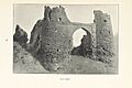
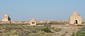
Soltangala (meaning "Sultan Qala," the sultan's fortress) is the largest of Merv's cities. It was built by Abu Muslim, the leader of the Abbasid rebellion. This marked the start of the new Caliphate. The area was quickly walled and became the heart of medieval Merv. Many fortified buildings called köshks were found here. These were two-story palaces with unique wavy walls. They were homes for Merv's important people.
Merv's largest and best-preserved Abbasid köşk is the Greater Gyzgala (meaning "maiden's fortress"). It is just outside Soltangala's western wall. It had 17 rooms around a central courtyard. The nearby Lesser Gyzgala had very thick walls.

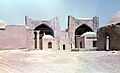
The most important buildings still standing in Soltangala are from the Seljuk period. When Seljuk leader Toghrul conquered Merv in 1037, the city became very lively again. Under his descendants, especially Sanjar, Merv became the center of a large empire.
Evidence of this wealth is everywhere in Soltangala. Many buildings are in the Shahryar Ark, the sultan's citadel. In the center of the Shahryar Ark is the Seljuk palace, probably built by Sanjar. This palace was relatively small but had tall rooms around a central courtyard. There was likely a large garden with an artificial lake.
Another interesting Seljuk building in the Shahryar Ark is the kepderihana (meaning "pigeon house"). This mysterious building has many niches in its walls. Some believe it was a pigeon roost, used to raise pigeons for their droppings. Pigeon droppings were used as fertilizer for melons, which Merv was famous for. Others think these buildings were libraries or treasuries.

The best-preserved building in all of Merv is the 12th-century mausoleum of Sultan Sanjar. It is the largest Seljuk mausoleum. It is a square building, 27 meters (89 feet) on each side. A large central dome covers the inside. The outside of the dome was turquoise. It was so tall that people said caravans could see it a day's march away from the city.
The walls of Soltangala are another important Seljuk remain. These fortifications were originally 8 to 9 meters (26 to 30 feet) high mud brick structures. They had chambers for defenders to shoot arrows. However, these walls were not thick enough to stop catapults. So, they were greatly strengthened later. A second, smaller wall was built in front of the main wall.
Many pottery pieces have been found from the Abbasid and Seljuk times. These include red bowls with geometric designs and yellow and green pottery. Turquoise and black bowls were found in the Shahryar Ark palace. Also, some Mongol-style pottery was found, perhaps from when the city was briefly rebuilt after the Mongol invasion.
Shaim Kala
Shaim Kala was built in the 600s AD. It was a separate walled city. It was meant to help with overcrowding and to deal with new people coming to Merv.
Abdyllahangala
Abdyllahangala is the city from the Timurid era. It is located south of the main Merv complex.
People and Life in Merv Today
Today, the ancient Merv site is near the city of Baýramali in Turkmenistan. The population of Baýramali was about 88,486 in 2009.
The people living in the Merv oasis today are mostly Turkmens from the Teke tribe. There are also some Persians or Tajiks. Smaller groups like the Beluch and Brahui also live there.
Merv's Economy
The Merv oasis gets its water from a complex system of canals from the Murghab River. The land here is very fertile. Many kinds of grains and fruits grow in large amounts, such as wheat, millet, barley, and melons. Rice and cotton also grow well. Cotton seeds found from the 400s show that cotton textiles were an important part of the economy even then.
People also raised Silkworms. The Turkmens had a famous breed of horses called Turkoman horse. They also kept camels, sheep, cattle, donkeys, and mules. People in Merv were skilled in working with silver and making armor. Archaeologists found a workshop from the 800s or 900s where crucible steel was made. This confirms old reports that the Khorasan region produced steel.
Merv's Location

The Merv oasis is on the Murghab River. This river flows from Afghanistan into the southern edge of the Karakum Desert. Merv is about 370 kilometers (230 miles) north of Herat and 450 kilometers (280 miles) south of Khiva. The oasis covers about 4,900 square kilometers (1,900 square miles).
Merv's location was very good for trade. It was in the middle of the Murghab River delta. This gave Merv two main advantages:
- It provided an easy route from the Afghan mountains towards the Karakum desert and the Amu Darya valley.
- The Murghab delta was a large, well-watered area in the dry Karakum. This made it a natural stopping point for trade routes from northwest Iran towards Transoxiana—the famous Silk Roads.
Merv was at the meeting point of these two routes. One route went southeast to Herat and Balkh (and beyond to India). The other went northeast from Tus and Nishapur to Bukhara and Samarkand. This made Merv a key stop on the Silk Road during the time of the Han dynasty. Merchants could trade for fresh horses or camels at this oasis city.
Climate of Merv
Merv has a dry and hot summer, and a cold winter. The summer heat can be very strong. Winds often create clouds of fine dust, making it hard to see and breathe. In winter, the weather is usually pleasant. Snow rarely falls, and when it does, it melts quickly. The area gets very little rain, often none from June to October. In summer, temperatures can reach 45°C (113°F). In winter, they can drop to -7°C (19°F). The average yearly temperature is 16°C (61°F).
Images for kids
-
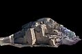
Photo-textured 3D laser scan image of Gäwürgala town walls
-
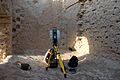
Interior of Kepderihana, with a 3D laser scanner positioned for work
-
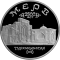
Landmarks of ancient Merv on a 1993 Russian commemorative coin
-
Merv Mosque (end of the 19th century)
-
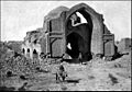
Ancient Merv (end of the 19th century)
-
Merv, 1899
-
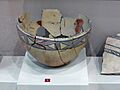
Merv pottery
-
Great Kyz Kala
-
Interior of the Ice House
-
Kyz Bibi mausoleum complex
-
1981 photo of the tomb of the Eskhab brothers on the territory of ancient Merv
-
Hormizd I Kushanshah, Merv mint


.jpg)
.jpg)

.jpg)

.jpg)


See also
- Greater Khorasan
- Nishapur
- Herat
- Balkh
- Gunar Tepe
- Margiana
- Mary, Turkmenistan
- Bayramali
- Murghab river
- List of World Heritage Sites in Turkmenistan
- Tahmuras, the mythical father and founder of Merv
