
Manama facts for kids
Quick facts for kids
Manama
الْمَنَامَة
|
|
|---|---|
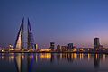
   .jpeg) Clockwise from top: Bahrain World Trade Center; skyline with roads, towers and harbour of Manama; night view of Manama City; and Manama City view
|
|

Manama
Location in Bahrain

Manama
Location in Persian Gulf

Manama
Location in Asia
|
|
| Country | |
| Governorate | Capital |
| Area | |
| • Capital city | 30 km2 (10 sq mi) |
| Population | |
| • Estimate
(2012)
|
297,502 |
| • Density | 5,200/km2 (13,000/sq mi) |
| • Urban
(2020)
|
635,000 |
| • Capital Governorate (2020) | 534,939 |
| Time zone | GMT+3 |
| Block number |
3XX–4XX
|
Manama (Arabic: الْمَنَامَة el-Menâme) is the capital and largest city of Bahrain. In 2012, its population was about 297,502 people. For a long time, Manama has been an important trading center in the Persian Gulf. It is home to many different kinds of people from all over the world.
Bahrain was controlled by the Portuguese and Persia for a while. It was also briefly invaded by Saudi Arabia and then by Oman. Finally, Bahrain became an independent nation in 1971, after a period when the British had a lot of influence.
Manama and the nearby city of Muharraq both started around the 1800s. Muharraq was the capital until 1923 because it was easier to defend. Manama became the main trading city and the entry point to the island of Bahrain. In the 20th century, Bahrain found oil, which helped Manama grow very quickly. In the 1990s, the city worked to grow other industries. This helped Manama become an important financial center in the Middle East. In 2012, the Arab League named Manama the "capital of Arab culture."
Contents
- Understanding the Name of Manama
- Manama's Journey Through Time
- Manama's Economy: A Financial Hub
- Manama's People: A Diverse Community
- Getting Around Manama: Transport Options
- Learning in Manama: Education
- Manama's Environment: Geography and Climate
- Manama's Culture and Lifestyle
- Twin Towns and Sister Cities
- Images for kids
- See also
Understanding the Name of Manama
The name "Manāmah" was first written down around the year 1330 AD. This was when Turān Shah from Hurmuz visited the island.
Some people believe the name comes from the Arabic word الْمَنَامَة (el-Menâme). This word means "the place of rest" or "the place of dreams."
Originally, the city was just called "Manamah" before it became "Al-Manamah." In Persian, "man" (من) means "me," and "nameh" (نامه) means "letter." This is similar to words like "Shah Nameh" (Book of Kings).
Bahrain has historical ties to Persian culture. This connection comes from empires like the Sassanian and Achaemenid. This history suggests that some place names in Bahrain might have Persian roots. For example, the city of Shah Khorah in Bahrain also shows this Persian influence.
Manama's Journey Through Time
Ancient Beginnings: Early Settlements
People have lived on Bahrain's northern coast since the Bronze Age. The Dilmun civilization lived here around 3000 BC. It was a key trading spot between Mesopotamia, Magan, and the Indus Valley civilisation. About 100,000 Dilmun burial mounds have been found. Some of these are 5,000 years old.
Even with these mounds, there is not much proof of large cities during the Dilmun time. Most people probably lived in the countryside. An officer from Alexander the Great's ships confirmed a large rural population. A big system of water channels in northern Bahrain helped with farming long ago.

The Dilmun trading network lasted for almost 2,000 years. Then, the Assyrians took control in 700 BC. After them came the Babylonians and Achaemenids. Later, Greek influence grew during Alexander the Great's time. In the first century AD, the Roman writer Pliny the Elder wrote about Tylos. This was the Greek name for Bahrain. He mentioned its pearls and cotton fields.
The island then came under the Parthian and Sassanid empires. During this time, Nestorian Christianity began to spread in Bahrain. By 410–420 AD, a Nestorian bishopric and monastery were built in Al Dair. This was on the nearby island of Muharraq. Bahrain became Islamic in 628 AD. Work on one of the first mosques in the area, the Khamis Mosque, started around the seventh century AD. During this period, Bahrain was involved in long-distance sea trade. This is shown by the discovery of Chinese coins from 600 to 1200 AD in Manama.

In 1330, the island became part of the Kingdom of Hormuz. The town of Manama was first mentioned in a document from 1345 AD. Bahrain, especially Manama and Bilad Al Qadeem, became a center for Shia religious learning. This continued for centuries. Religious scholars helped fund pearling trips and grow grain in the areas around the city. In 1521, Bahrain was taken by the Portuguese Empire. They built the Bahrain Fort near Manama to control the island. After many revolts, the Portuguese were forced out in 1602, and the Safavids from Persia took over.
Early Modern Times: New Rulers
The Safavids made Bilad Al Qadeem the capital, not Manama. This town was also where the Persian governor lived. Bahrain continued to be a center for Twelver Shi'ism studies. Farmers grew many date palms and other crops in northern Bahrain. A traveler named Pedro Teixeira noted the large farms of barley and wheat.
Opening Persian markets to Bahraini goods, especially pearls, helped the island's economy. Bahrain earned 600,000 ducats a year from pearls. About 2,000 pearling boats were used. Also, many Shia farmers moved from Ottoman-controlled Qatif and al-Hasa in 1537. They feared religious persecution. Around 1736, Nader Shah built a fort on the southern edge of Manama.
Persian control in the Persian Gulf weakened in the late 1700s. In 1783, the Bani Utbah tribe invaded Bahrain. They removed the governor, Nasr Al-Madhkur. The Al Khalifa family then became the rulers of Bahrain. All ties with Persia ended. Ahmed ibn Muhammad ibn Khalifa became the first ruler of this new dynasty.
Political problems in the 1800s hurt Manama's economy. Invasions by the Omanis in 1800 and the Wahhabis in 1810–11 caused trouble. A civil war in 1842 also made Manama a battleground. This made trade stop. The port closed, and many merchants left for Kuwait and the Persian coast. When the fighting stopped, they returned. In 1862, a scholar named William Gifford Palgrave visited Manama. He said the town had a few ruined stone buildings and many huts belonging to poor fishermen and pearl-divers.

In the 1800s, the British started to control trade routes, especially those near British India. To stop piracy in the Persian Gulf, the British sent warships. They made many Persian Gulf states, including Bahrain, sign the General Maritime Treaty of 1820. This treaty banned piracy and slavery. In 1861, Britain and Bahrain signed the Perpetual Truce of Peace and Friendship. This meant Britain would defend Bahrain, and in return, Britain would control Bahrain's foreign affairs.
When Isa ibn Ali Al Khalifa became the ruler of Bahrain in 1869, Manama became the center of British activity. Trade fully recovered by 1873. The country's earnings from pearl exports grew seven times between 1873 and 1900. British representatives, often from groups like Persians, reported to British India. In 1900, the British built their political office in Manama. This made Britain's position in the city even stronger.

Modern Growth: Oil and Independence

When World War I started in 1914, the British Raj used Manama as a military base. Because there was oil in the region, the British made an agreement with the ruler. This agreement stopped oil exploration for five years. In 1919, Bahrain officially became part of the British empire. A new law gave the British political agent more power.
The British pushed for changes in Bahrain during the 1920s. The old ruler, Isa ibn Ali Al Khalifa, had to step down. His son, Hamad ibn Isa Al Khalifa, who wanted reforms, took over. A city government was set up in Manama in 1919. The Customs office was reorganized in 1923. Its earnings went into a new state treasury. Civil courts started in 1923, and a land registration department in 1924. Charles Belgrave was appointed in 1926 to help with reforms. He managed finances and land, and organized the State Police.


In 1927, Bahrain's pearling economy crashed. This was because Japan started selling cultured pearls. Between 1929 and 1931, pearl businesses lost over two-thirds of their money. The Great Depression made things worse. Many Bahraini business people and pearl-divers went into debt.
The discovery of oil in 1932 changed everything. Oil exports started in 1934. This made Bahrain much more important in global politics. The British wanted to make sure they had oil supplies, especially before World War II. The oil industry slowly hired the pearl divers who had lost their jobs. The pearling industry eventually disappeared.
During the war, Bahrain was a key airbase between Britain and India. It also had RAF Muharraq and a naval base in Juffair. The Italian Air Force bombed Bahrain in 1940. After the war and India's independence in 1947, the main British office in the Persian Gulf moved to Manama.


After the rise of Arab nationalism and the Suez Crisis in 1956, protests against the British happened in Manama. These were organized by the National Union Committee. Even though the committee wanted peaceful protests, some buildings and businesses belonging to Europeans were set on fire. The main Catholic church and petrol stations were also targeted. Protesters demanded that Charles Belgrave be removed. He was dismissed the next year. The National Union Committee was later dissolved.
Another protest happened in March 1965. This one was mainly led by students who wanted independence. In 1968, the British announced they would leave Bahrain by 1971. The newly independent State of Bahrain made Manama its capital city.


After independence, Manama grew very fast. Nearby villages became part of the city. New areas like Adliya and Salmaniya were built. Many foreigners from the Indian subcontinent came to work. By 1981, there were twice as many foreigners as Bahrainis. The building of the Diplomatic Area helped the country's economy. It moved away from relying only on oil by focusing on finance. By 1986, there were 187 financial companies in this area.
Because there was not much land for building, new land was created from the sea. Religious activities moved from Manama to areas like Bani Jamra and Bilad Al Qadeem. These areas were centers of protests in the 1990s. People wanted an elected parliament again. In 2001, the National Action Charter was approved. This led to the first parliamentary and city elections in many years. More elections happened in 2006 and 2010. In 2011, there was a month-long period of protests. Forces from other Gulf countries stepped in, and a three-month state of emergency was declared. A report was published about the events of 2011.
Manama's Economy: A Financial Hub

Manama is the most important part of Bahrain's economy. Oil is still important, but it is less so now. This is because oil reserves are running low, and other industries are growing. Industries like aluminum smelting (melting metal), ship repair, banking, finance, and tourism have grown a lot recently. Many international companies have offices in Manama.
The main industry in Manama is financial services. There are over two hundred financial companies and banks in the city's business areas. Manama is a financial center for the Persian Gulf region. It is also a key place for Islamic banking. There are many shops in the malls around Seef. The center of Manama has many small workshops and traders.
In the early 1900s, Manama's economy depended a lot on pearling. In 1907, about 917 boats were used for pearling, employing up to 18,000 people. Shipbuilding also employed hundreds in Manama and Muharraq. The money earned from pearling was about £1.5 million each year before the Great Depression. Custom duties and tariffs (taxes on goods) were the government's main source of money. When the Great Depression hit and the pearling industry collapsed, the discovery of oil in 1932 shifted the country's economy towards oil.
Historically, Manama's ports were not very good. The British said in 1911 that goods were exposed to bad weather and there were long delays. Indians later helped improve the ports. By 1920, Manama was a main exporter of Bahrain pearls. It attracted steamships from India. At that time, they also imported goods like rice, textiles, coffee, dates, and fuel. They exported pearls, oysters, and sailcloth. In 1911–12, 52 steamships visited Manama. Most were British.
Manama's People: A Diverse Community
| Historical population | ||
|---|---|---|
| Year | Pop. | ±% |
| 1860s | 8,000 | — |
| 1904 | 25,000 | +212.5% |
| 1941 | 27,835 | +11.3% |
| 1950 | 39,648 | +42.4% |
| 1959 | 61,726 | +55.7% |
| 1965 | 79,098 | +28.1% |
| 1971 | 88,785 | +12.2% |
| 1981 | 121,986 | +37.4% |
| 2010 | 329,510 | +170.1% |
| Source: Bahrain Census 2010 | ||
Manama is a port city, so it has always attracted people looking for a better life. Because of this, Manama is often called a cosmopolitan city. This means it has people from many different countries and cultures. In 1904, Manama had about 25,000 people. Half of them were thought to be foreigners from places like Basra, Najd, al-Hasa, Iran, India, and Europe.
Religious Communities
The two main branches of Islam, Shia Islam and Sunni Islam, have lived side-by-side in Manama for centuries. They are made up of different ethnic groups. The Shia community includes native Arab Baharna, people from Hasawis and Qatif in mainland Arabia, and Persian Ajam. The Sunni community includes Arab Bedouin tribes who moved there in the 1700s, along with the Bani Utbah and the Huwala.
Getting Around Manama: Transport Options
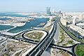
Roads and Connections
.jpg)


Manama is the main center for Bahrain's roads. The city's road system is being improved a lot to help with traffic. Since Manama is the capital and main city, it has most of the government and business offices. The number of cars is growing fast.
Road widening in old Manama districts started when the first car arrived in 1914. The number of cars grew from 395 in 1944 to 18,372 in 1970. This made city planning focus on expanding roads and adding more parking. Many old paths were paved and widened into main roads. The main roads in the Manama Souq district were widened by tearing down some houses.
Several ring roads were built over time. These include Isa al Kabeer avenue in the 1930s and Al Fateh highway in the 1980s. These roads helped expand the city area. To the north, the coastline moved outwards. To the east, a bridge connected Manama to Muharraq in 1929. A new causeway was built in 1941. Travel between the two islands increased after the Bahrain International Airport opened in 1932.
To the south of Manama, roads connected to areas like Hoora and Juffair. Villages like Mahooz were at the end of these roads. To the west, a major highway linked Manama to the port village of Budaiya. This highway went through farming villages. To the south, a road connected Manama to Riffa. The discovery of oil made the city's road network grow even faster.

The four main islands and all towns are connected by good roads. In 2002, there were 3,164 km of roads, with 2,433 km paved. A causeway of 2.8 km connects Manama with Muharraq Island. Another bridge joins Sitra to the main island. A four-lane highway on a 24 km causeway links Bahrain to Saudi Arabia. This was finished in December 1986 and paid for by Saudi Arabia. In 2000, there were 172,684 passenger cars and 41,820 commercial vehicles.
Bahrain's port, Mina Salman, can hold 16 large ships. In 2001, Bahrain had eight merchant ships. Private cars and taxis are the main ways to get around the city.
Bus Services

Manama has a bus service that started on April 1, 2015. It uses 141 MAN buses. The Ministry of Transportation manages the bus routes. These routes go across Bahrain and around Manama.
Air Travel
Bahrain International Airport is on the nearby Muharraq Island. It is about 7 km from the main business area. It is a major airport in the Middle East. The airport is located between the important markets of Saudi Arabia and Iran. It has many flights to regional and international places in Europe, Asia, Africa, and North America.
Bahrain also has a military airbase called the Isa Air Base. It is in the south at Sakhir. This is the base for the Bahrain Defence Force.
Learning in Manama: Education

Before the 1900s, Quranic schools were the only way to get an education in Bahrain. These schools mainly taught the Qur'an. The first modern school opened in 1892 in Manama. It was an elementary school started by the Reformed Church in America. It taught English, Math, and Christianity. Important merchants sent their children there until it closed in 1933 due to money problems. The school reopened later as Al Raja School and is still open today. Another private school, Al-Ittihad school, opened in 1910. It was funded by the Persian community.
After World War I, Western ideas became more common. The first public school for boys, Al-Hidaya Al-Khalifia Boys school, opened in Muharraq in 1919. Important citizens of Muharraq founded it, and the Bahraini royal family supported it. The country's first Education Committee was set up by leading merchants. Shaikh Abdulla bin Isa Al-Khalifa, the ruler's son, led this committee. He acted as the Minister of Education. He suggested the idea for the school after visiting England.
In 1926, a second public school for boys, Jafaria School, opened in Manama. Two years later, in 1928, the first public school for girls was started. Because the Education Committee had money problems, the Bahraini government took control of the schools in 1930.
Today, Manama has many private and public universities and colleges. These include Ahlia University, Applied Science University, and Arabian Gulf University. Other notable schools in the city are the Bahrain School and the Indian School.
Manama's Environment: Geography and Climate
Manama is located in the northeast corner of Bahrain. It sits on a small piece of land that sticks out into the sea. Like the rest of Bahrain, the land is mostly flat and dry.

Weather in Manama
Manama has a very dry climate. Like the rest of Bahrain, Manama has extreme weather. Summer temperatures can reach up to 45°C (113°F). In winter, temperatures can drop as low as 7°C (45°F), and sometimes it even hails. Average temperatures in summer are about 34°C (93°F), and in winter about 17°C (63°F). The best time to visit Bahrain is spring. The sun is not as strong, and the temperatures are mild with gentle breezes.
| Climate data for Manama (Bahrain International Airport) 1991–2020 normals, extremes 1902–present | |||||||||||||
|---|---|---|---|---|---|---|---|---|---|---|---|---|---|
| Month | Jan | Feb | Mar | Apr | May | Jun | Jul | Aug | Sep | Oct | Nov | Dec | Year |
| Record high °C (°F) | 29.7 (85.5) |
34.7 (94.5) |
38.1 (100.6) |
41.3 (106.3) |
46.7 (116.1) |
47.3 (117.1) |
47.5 (117.5) |
45.6 (114.1) |
45.5 (113.9) |
42.8 (109.0) |
37.2 (99.0) |
30.6 (87.1) |
47.5 (117.5) |
| Mean daily maximum °C (°F) | 20.7 (69.3) |
22.0 (71.6) |
25.5 (77.9) |
30.6 (87.1) |
36.1 (97.0) |
38.6 (101.5) |
39.7 (103.5) |
39.6 (103.3) |
37.7 (99.9) |
34.0 (93.2) |
28.0 (82.4) |
22.9 (73.2) |
31.3 (88.3) |
| Daily mean °C (°F) | 17.5 (63.5) |
18.4 (65.1) |
21.3 (70.3) |
26.0 (78.8) |
31.1 (88.0) |
34.0 (93.2) |
35.1 (95.2) |
35.1 (95.2) |
33.2 (91.8) |
29.9 (85.8) |
24.6 (76.3) |
19.7 (67.5) |
27.2 (80.9) |
| Mean daily minimum °C (°F) | 14.5 (58.1) |
15.4 (59.7) |
18.1 (64.6) |
22.4 (72.3) |
27.2 (81.0) |
30.0 (86.0) |
31.4 (88.5) |
31.5 (88.7) |
29.5 (85.1) |
26.4 (79.5) |
21.6 (70.9) |
16.8 (62.2) |
23.7 (74.7) |
| Record low °C (°F) | 2.7 (36.9) |
7.9 (46.2) |
10.9 (51.6) |
10.8 (51.4) |
18.7 (65.7) |
18.4 (65.1) |
25.3 (77.5) |
21.8 (71.2) |
18.9 (66.0) |
18.8 (65.8) |
11.7 (53.1) |
6.4 (43.5) |
2.7 (36.9) |
| Average precipitation mm (inches) | 18.1 (0.71) |
13.0 (0.51) |
14.7 (0.58) |
7.5 (0.30) |
8.0 (0.31) |
0.0 (0.0) |
0.0 (0.0) |
0.0 (0.0) |
0.0 (0.0) |
0.9 (0.04) |
16.8 (0.66) |
15.2 (0.60) |
94.2 (3.71) |
| Average precipitation days (≥ 1.0 mm) | 2.5 | 1.9 | 2.5 | 1.3 | 0.3 | 0.0 | 0.0 | 0.0 | 0.0 | 0.2 | 1.6 | 2.3 | 12.6 |
| Average relative humidity (%) | 69.1 | 67.2 | 61.5 | 54.4 | 47.6 | 46.2 | 50.7 | 58.0 | 59.2 | 62.3 | 63.6 | 68.7 | 59.0 |
| Average dew point °C (°F) | 11.5 (52.7) |
11.8 (53.2) |
13.1 (55.6) |
15.4 (59.7) |
17.8 (64.0) |
19.9 (67.8) |
22.5 (72.5) |
25.0 (77.0) |
23.7 (74.7) |
21.5 (70.7) |
17.0 (62.6) |
13.7 (56.7) |
17.7 (63.9) |
| Mean monthly sunshine hours | 232 | 221 | 245 | 256 | 316 | 344 | 337 | 334 | 316 | 306 | 249 | 235 | 3,391 |
| Source: NOAA, Meteo Climat (record highs and lows) | |||||||||||||
Manama's Culture and Lifestyle

Manama attracts many people from other countries. Almost one-third of the population is from abroad. Football is the most popular sport in Manama and all of Bahrain. Three teams from Manama play in the Bahraini Premier League.
Important cultural places in Manama include the Bab Al Bahrain and the market area next to it. In the 2010s, the old part of Manama and the Manama souq were being updated. This work was planned to finish in 2020. The central areas of Manama are also where the main Muharram processions happen. Hundreds of thousands of people from Bahrain and other Gulf countries come to these events every year.
Twin Towns and Sister Cities
|
Images for kids
-
Bahrain World Trade Center
-
Manama skyline
-
Manama City view
-

Manama Night view
See also
 In Spanish: Manama para niños
