Syr Darya facts for kids
Quick facts for kids Syr Darya |
|
|---|---|

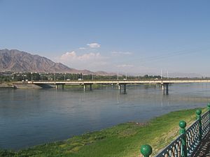
Syr Darya at Kyzylorda, Kazakhstan
|
|

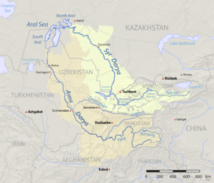
Map of area around the Aral Sea. Aral Sea boundaries are c. 2008. The Syr Darya drainage basin is in yellow, and the Amu Darya basin in orange.
|
|
| Other name(s) | Jaxartes |
| Country | Kyrgyzstan, Uzbekistan, Tajikistan, Kazakhstan |
| Cities | Khujand, TJ, Tashkent, UZ, Turkestan, KZ, Kyzylorda, KZ, Baikonur, RU |
| Physical characteristics | |
| Main source | Confluence of Naryn and Kara Darya Fergana Valley, Uzbekistan 400 m (1,300 ft) 40°54′03″N 71°45′27″E / 40.90083°N 71.75750°E |
| River mouth | North Aral Sea Kazaly, Kazakhstan 42 m (138 ft) 46°09′15″N 60°52′25″E / 46.15417°N 60.87361°E |
| Length | 2,256.25 km (1,401.97 mi) |
| Basin features | |
| Basin size | 402,760 km2 (155,510 sq mi) |
| Tributaries |
|
| Protection status | |
| Official name: Lesser Aral Sea and Delta of the Syrdarya River | |
| Designated: | 2 February 2012 |
| Reference #: | 2083 |
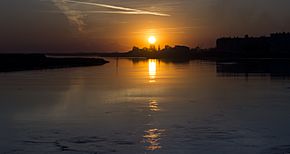
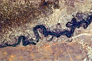
The Syr Darya is a long river in Central Asia. Its name comes from the Persian language and means Syr Sea or Syr River. This river starts in the Tian Shan Mountains in Kyrgyzstan and eastern Uzbekistan. It flows for about 2,256 kilometers (1,402 miles) through Uzbekistan and southern Kazakhstan. Finally, it reaches the northern part of the Aral Sea.
The Syr Darya is one of the two main rivers that feed the Aral Sea. The other big river is the Amu Darya. During the time of the Soviet Union, many irrigation projects were built. These projects took a lot of water from both rivers to water farms. This caused the Aral Sea to shrink a lot, almost disappearing. It used to be the fourth-largest lake in the world. The lowest point in Tajikistan is where the river flows into Uzbekistan, about 300 meters (984 feet) above sea level.
| Top - 0-9 A B C D E F G H I J K L M N O P Q R S T U V W X Y Z |
History of the Syr Darya
Long ago, in 329 BCE, the army of Alexander the Great reached the Syr Darya. At that time, the river was known as the Jaxartes. When Alexander's army arrived, they faced resistance from local tribes. Alexander founded a city on the river's banks. He named it Alexandria Eschate, which means "the farthest Alexandria." Today, this city is called Khujand and is in Tajikistan.
In the mid-1800s, during the Russian conquest of Turkestan, the Russian Empire started using steam boats on the Syr Darya. This helped with transport and trade.
During the Soviet Union era, countries like Kyrgyzstan and Tajikistan shared water from the Syr Darya and Amu Darya rivers. They shared it with Kazakhstan, Turkmenistan, and Uzbekistan during the summer. In return, Kyrgyzstan and Tajikistan received coal, gas, and electricity in winter. After the Soviet Union ended in 1991, this system stopped working. The Central Asian countries have struggled to manage water resources since then. Old irrigation methods and poor water management make the problem worse.
In 2012, the Syrdarya–Turkestan State Regional Natural Park was created in Kazakhstan. This park helps protect the river's natural areas, old historical sites, and many plants and animals. Some of these species are rare or in danger.
Geography of the River
The Syr Darya starts from two smaller rivers, the Naryn River and the Kara Darya. These rivers begin in the Tian Shan Mountains in Kyrgyzstan and eastern Uzbekistan. They join together in the Fergana Valley in Uzbekistan. From there, the Syr Darya flows west and then northwest for about 2,212 kilometers (1,375 miles). It passes through Uzbekistan and southern Kazakhstan before reaching the remains of the Aral Sea.
The area that the Syr Darya drains is huge, over 800,000 square kilometers (308,882 square miles). However, only a smaller part of this area actually sends a lot of water to the river. Some large rivers in its basin, like the Talas River and the Chu River, dry up before they even reach the Syr Darya. The amount of water flowing in the Syr Darya each year is about half of what flows in its sister river, the Amu Darya.
Along its path, the Syr Darya provides water to some of the best farming areas in all of Central Asia. It also supplies water to important towns like Kokand, Khujand, Kyzylorda, and Turkestan. For centuries, local governments have built and maintained many canals. These canals are very important in this dry region. Many canals were not used in the 1600s and early 1700s. But the Khanate of Kokand rebuilt many of them in the 1800s, especially along the upper and middle parts of the river.
What's in a Name?
The name of the river has changed over time. The second part of the name, Darya, means "lake" or "sea" in Persian. In Central Asian Persian, it means "river." The name "Syr Darya" has only been used since the 1700s.
The oldest known name for the river was Jaxartes. This name was used by the Ancient Greeks. It might come from an Old Persian name, Yakhsha Arta, which means "True Pearl." This could refer to the clear, icy color of its water from the glaciers. Another old name for the river was Yinçü, which also means "Pearl river."
After the Muslim conquest of the region, the river was called Seyhun. This name comes from Arabic and refers to one of the four rivers believed to flow from Paradise.
The current local name of the river, Syr, did not appear until the 1500s. In the 1600s, a historian and ruler named Abu al-Ghazi Bahadur Khan called the Aral Sea the "Sea of Sïr."
Environmental Challenges
During the Soviet Union era, many irrigation canals were built along the Syr Darya. These canals took a lot of water to grow crops like cotton and rice. This caused a lot of environmental damage to the area. So much water was taken from the river that sometimes, no water at all reached the Aral Sea. The Amu Darya river in Uzbekistan and Turkmenistan faced a similar problem. This massive water diversion led to the shrinking of the Aral Sea.
The water in the Syr Darya also has higher levels of uranium in some parts of Tajikistan. This means the water might not be safe for drinking in those areas. Most of this uranium comes from upstream areas in Uzbekistan and Kyrgyzstan.
See also
 In Spanish: Sir Daria para niños
- Extreme points of Tajikistan
- History of the central steppe
- Great Fergana Canal
- Daryalyktakyr
 | William Lucy |
 | Charles Hayes |
 | Cleveland Robinson |


