Fergana Valley facts for kids
Quick facts for kids Fergana Valley |
|
|---|---|
| Farg‘ona vodiysi, Фергана өрөөнү, водии Фaрғонa, Ферганская долина, وادی فرغانه |
|
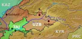
Fergana Valley (highlighted), post-1991 national territories colour-coded
|
|
| Length | 300 km (190 mi) |
| Area | 22,000 km2 (8,500 sq mi) |
| Geography | |
| Location | Kyrgyzstan, Tajikistan, Uzbekistan |
| Rivers | Syr Darya river (Naryn and Kara Darya) |
The Fergana Valley is a large valley in Central Asia. It spreads across eastern Uzbekistan, southern Kyrgyzstan, and northern Tajikistan.
This valley is a very fertile area. Its rich soil comes from two rivers, the Naryn and the Kara Darya. These rivers flow from the east and meet near Namangan, forming the Syr Darya river. The valley has a long history, going back over 2,300 years. Alexander the Great founded a city here called Alexandria Eschate.
For over 2,100 years, Chinese writers have mentioned the valley's towns. It was an important path between different ancient civilizations. Later, Babur, who started the Mughal Dynasty, came from this region. This connected the valley to modern Afghanistan and South Asia.
The Russian Empire took control of the valley in the late 1800s. In the 1920s, it became part of the Soviet Union. The three countries that share the valley today became independent in 1991. Most people in the valley are Muslim. They belong to different ethnic groups like Uzbek, Tajik, and Kyrgyz people. These groups often live mixed together, not always matching the modern country borders.
Today, growing cotton is very important for the valley's economy. This practice was started by the Soviets. Farmers also grow many other crops like grains, fruits, and vegetables. People here have a long history of raising animals and working with leather. There is also a growing mining industry. They find things like coal, iron, sulfur, gypsum, rock-salt, and some oil.
Contents
Understanding the Valley's Name
The Fergana Valley can also be spelled as Farghana or Ferghana. In other languages spoken in the region, it is known by different names:
- Uzbek: Farg‘ona vodiysi (Uzbek)
- Kyrgyz: Фергана өрөөнү (Kyrgyz)
- Tajik: Водии Фарғона (Tajik)
- Russian: Ферганская долина (Russian)
- Persian: وادی فرغانه (Persian)
Land and Landscape of Fergana Valley
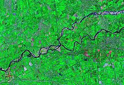
The Fergana Valley is like a big bowl surrounded by mountains. The Tien-Shan mountains are to the north, and the Gissar-Alai mountains are to the south. The valley is about 300 kilometres (190 mi) long and up to 70 kilometres (43 mi) wide. This makes it about 22,000 square kilometres (8,500 sq mi) in total. Its location makes it a special geographic area.
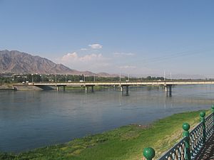
The valley is very fertile because of two rivers: the Naryn and the Kara Darya. They meet near Namangan to form the Syr Darya. Many smaller rivers also flow into these main ones. These rivers bring water for farming. They also carry a lot of sand. This sand builds up, especially near the Syr Darya. Sometimes, strong winds can blow this sand into farming areas.
Deep underground, the valley is like a sunken block of earth. It is filled with layers of sediments (like dirt and rocks) that have built up over millions of years. There are also cracks in the earth called faults. These faults can trap petroleum (oil) and natural gas. Small oil fields have been found in the valley.
Weather in the Valley
The climate in the Fergana Valley is usually dry and warm. In March, the temperature can reach 20 °C (68 °F). It quickly gets hotter, reaching 35 °C (95 °F) in June, July, and August. From April to September, there is not much rain. Rain becomes more common starting in October. In December and January, it can get very cold, with snow and frost. Temperatures can drop to -20 °C (-4 °F).
A Look at Fergana's Past
The Fergana Valley has always been an important place. It sits on the route to the Tarim Basin from the west. This meant it was often on the edge of many powerful ancient empires.
Early Empires and Greek Influence
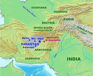
Around 500 BC, the western part of the Fergana Valley was part of a region called Sogdiana. This area was ruled by the Achaemenid Empire (Persians). Sogdiana was a strong border region. It protected the Persians from nomadic groups to the north and east. Later, Alexander the Great captured a fortress here in 327 BC. After a long fight, Alexander combined Sogdiana with another region called Bactria.
In 329 BC, Alexander founded a city called Alexandria Eschate. This means "The Furthest" city. It was located in the southwestern part of the valley, where the modern city of Khujand in Tajikistan is today. This city was settled by Alexander's soldiers. It later came under the rule of the Seleucid Empire.
After 250 BC, the city likely stayed in touch with the Greco-Bactrian Kingdom. This kingdom was based in Bactria. There are signs that Greeks from Alexandria Eschate traveled as far as Kashgar in China. This led to some of the first known contacts between China and the Western world around 220 BC.
Chinese Connections and Heavenly Horses
The Chinese called the Fergana area Dayuan. They believed the people of Dayuan might be descendants of Greek settlers. The region was famous for its amazing "Heavenly Horses." The Chinese wanted these horses very much. They even went to war in 104 BC to get them.
Chinese records describe the Dayuan people as having a developed city life. They were similar to the people of Bactria and Parthia. They grew grain and grapes for wine. The Fergana area was where Chinese and European cultures first met in a big way. This meeting helped open up the famous Silk Road trade route.
The Han dynasty later took control of Dayuan. They set up a local king there.
Kushan and Sassanid Empires
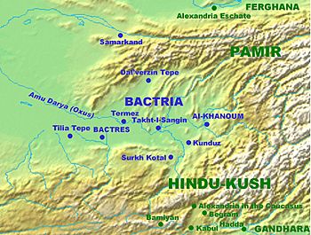
The Kushan Empire grew from the same Yuezhi people who had taken over Hellenistic Fergana. In the 1st century AD, the Kushans expanded. They conquered much of what is now northern India and Pakistan. Kushan rule also helped long-distance trade. It connected Central Asia with Han Dynasty China and the Roman Empire.
The Kushans ruled Fergana until the 3rd century AD. Then, the Zoroastrian Persian Sassanid Empire invaded. Fergana was then ruled by different local leaders. For a while in the 4th and 5th centuries, the Sassanid Empire directly controlled Fergana.
Turkic and Islamic Rule
The Hephthalites briefly ruled Fergana. Then, the Gokturks took over in the mid-6th century. They ruled until the early 700s.
The Ikhshids ruled the Kingdom of Ferghana. They were vassals of the Chinese Tang from 659 to 790. In 715, the Umayyad Caliphate (an Arab Muslim empire) tried to take control. But the Chinese sent troops and put the Ikhshid ruler back on the throne.
During the 8th century, Fergana was a place of strong competition. The Chinese Tang dynasty and the growing Muslim power both wanted control. The Battle of Talas in 751 was a key event. The Abbasids (another Muslim empire) won, and China pulled back from Central Asia. After this, a series of Arab, Persian, and later Turkic Muslim rulers governed Fergana.
Samanids, Karakhanids, and Khwarezmids
The Samanid Empire grew after the Arab Muslim conquest of Persia. They expanded into Fergana from the west. In 819, Ahmad ibn Asad was given authority over Fergana. His family, the Samanids, became powerful rulers of the valley.
When the Samanids declined in the 10th century, the Karakhanids conquered Fergana. Their rule lasted until 1212. Then, the Khwarezmshahs took over the western part of the valley.
Mongol and Turkic Empires
The Mongol ruler Genghis Khan invaded Fergana in 1219. After his death, his son Chagatai received the lands of Western Central Asia. This region became known as the Chagatai Khanate. Over time, Turkic leaders from this region gained power. The Fergana Valley became part of a larger Turco-Mongol empire.
One famous leader from this time was Timur. He founded the Timurid dynasty in the late 14th century. He added the valley to his empire, ruling from Samarkand.
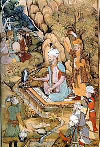
The Fergana Valley was important for the growth of medieval Central Asian Islam. Its most famous person is Babur. He was a descendant of Timur. Babur became a famous conqueror and started the Mughal dynasty in Medieval India. Many Islamic teachers from Fergana helped spread Islam to parts of Russia, China, and India.
From the 16th century, the Shaybanid Dynasty ruled Fergana. Later, in 1709, a local leader named Shahrukh declared independence. He built his capital in the town of Kokand. This new state became the Khanate of Kokand. It grew to cover much of modern eastern Uzbekistan, Tajikistan, southern Kazakhstan, and all of Kyrgyzstan.
Russian Empire Takes Control
In 1876, the Fergana Valley became a province of Russian Turkestan. It was formed from the old Khanate of Kokand. Its borders were set with neighboring regions and countries like Chinese Turkestan and Afghanistan. The total area was about 53,000 km2 (20,463 sq mi).
Not everyone was happy with Russian rule. In 1898, a leader named Muhammed Ali Khalfa called for a holy war against the Russians. He was captured and executed. Later, in 1905, a revolution spread across the Russian Empire. When the Russian government tried to make Muslims join the army, it led to a bigger revolt. This revolt was still going on when the Russian Revolution happened.
The Soviet Era and New Borders
In 1924, the Soviet Union redrew the borders. The Fergana Valley was split between the new Uzbek SSR and Kyrgyz SSR. In 1928, the area around Khujand became part of the Tajik ASSR. These new borders cut off the valley's natural routes to cities like Samarkand.
However, these borders did not matter much under Soviet rule. The whole region was part of one big economy. It focused on growing huge amounts of cotton. People could cross borders easily.
After the Soviet Union
When the Soviet Union broke up in 1991, the republics became independent countries. The new international borders were then strongly enforced. Uzbekistan often closes its borders with Tajikistan and Kyrgyzstan. This makes trade difficult and causes problems for people living in the region.
For example, people in Khujand, Tajikistan, cannot take the direct route through Uzbekistan to their capital, Dushanbe. They have to cross a difficult mountain pass instead. Travel between Bishkek and Osh in Kyrgyzstan also goes through tough mountains.
There have been some disagreements between ethnic groups. In 1990, there were riots in the town of Uzgen, near Osh. This was between Kyrgyz and Uzbek people. There was more violence in 2010 in the Kyrgyz part of the valley. This was due to ethnic tensions, economic problems, and political changes. In June 2010, about 200 people were killed in clashes in Osh and Jalal-Abad. Many people, mostly Uzbek, tried to flee to Uzbekistan.
Farming in the Valley
In the past, much of the farmland in Fergana was watered by irrigation. The soil was very well farmed. The main crops were cotton, wheat, rice, barley, maize, millet, lucerne, tobacco, vegetables, and fruit. People were very skilled at gardening. Many horses, cattle, and sheep were raised.
Large areas were covered with forests. The government even had a farm that gave away young trees to people. Raising Silkworms used to be a big industry, but it declined.
Industries and Resources
The Fergana Valley has deposits of coal, iron, sulfur, gypsum, rock-salt, and naphtha. However, only rock-salt and naphtha have been taken out in large amounts. In the late 1800s, there were some small oil wells, but they are not used anymore.
During the Russian Empire, the main industries were cotton cleaning factories. People also made leather goods, saddles, paper, and cutlery at home. Not much industry was added during Soviet times. Most factories were built in cities like Samarkand and Bukhara.
Trade and Economy
Historically, the Fergana Valley was a key stop on the Silk Road. This was a trade route for goods and people traveling between China, the Middle East, and Europe. After crossing mountain passes from Kashgar, traders found relief in Fergana's rich lands. They could also buy high-quality silk made in Margilan.
The most famous export from the region were the "Heavenly Horses." These horses were so special that the Chinese wanted them very much. In the 1800s, there was a lot of trade with Russia. The valley exported raw cotton, raw silk, tobacco, hides, and fruits. They imported manufactured goods, textiles, tea, and sugar.
Today, trade in the valley faces challenges. It suffers from economic difficulties, especially due to border closures with Uzbekistan. The main international export is cotton. However, a Daewoo car plant in Andijan sends cars all over Uzbekistan.
Getting Around the Valley
Until the late 1800s, people in Fergana used camels, horses, and donkeys to travel. Roads were few and not very good. The Russians built a main road in the 1870s. It connected cities like Andijan, Kokand, and Khujand with Samarkand and Tashkent.
Trade got a boost when the Transcaspian railway reached Andijan in 1898. Another railway, the Trans-Aral Railway, opened in 1906. Before Soviet times, routes to places like Kashgaria were just narrow paths over the mountains. These paths crossed high passes. For example, the Terek-davan pass is 3,720 metres (12,200 ft) (12,205 ft) high.
In 2016, the Angren-Pap railway line was finished. This gave the region a direct train connection to the rest of Uzbekistan. The Pap-Namangan-Andijon railway line is also being updated.
People of the Fergana Valley
In 1897, the valley had about 1.5 million people. Most of them lived in the valley itself. The mountain slopes were home to Kyrgyz people. Some were nomadic herders, while others farmed. Other groups included Kashgarians, Kipchaks, Bukharan Jews, and Romani. The ruling class was mainly Russian. Many merchants and factory workers were also Russian. Most of the people were Muslims.
The way the population was divided in 1897 generally matches the borders drawn after 1924. For example, the area around Khujand mostly spoke Tajik. The hills had Kyrgyz people. One exception is the city of Osh. It had mostly Uzbek people but ended up in Kyrgyzstan.
In 1924, Soviet policy changed how people were identified. All settled Turkic people in Central Asia were called "Uzbeks." This is why the Fergana Valley is now seen as a main Uzbek area.
How the Valley is Divided Today
In 1911, the province was split into five districts. The main towns were Fergana, Andijan, Kokand, Namangan, and Osh.
Today, the valley is shared by Uzbekistan, Kyrgyzstan, and Tajikistan.
- In Tajikistan, it is part of the Soghd Region, with its capital at Khujand.
- In Uzbekistan, it is divided into the Namangan, Andijan, and Fergana regions.
- In Kyrgyzstan, it includes parts of the Batken, Jalal-Abad, and Osh regions. Osh is the main city for the southern part of Kyrgyzstan.
Regions in the Fergana Valley
| Country | Region | Capital | Area (km²) | Population | Population density (/km2) | Wholly within the Valley |
|---|---|---|---|---|---|---|
| Kyrgyzstan | Batken | Batken | 17,000 | 469,700 | 28 | No |
| Jalal-Abad | Jalal-Abad | 33,700 | 1,099,000 | 33 | No | |
| Osh City | Osh | 50 | 265,200 | 5,300 | Yes | |
| Osh Region | Osh | 29,200 | 1,199,900 | 41 | No | |
| Tajikistan | Sughd | Khujand | 25,400 | 2,349,000 | 92 | No |
| Uzbekistan | Andijan | Andijan | 4,303 | 2,805,000 | 652 | Yes |
| Fergana | Fergana | 7,005 | 3,386,000 | 483 | Yes | |
| Namangan | Namangan | 7,101 | 2,504,000 | 353 | Yes | |
| Totals | 123,759 | 14,000,000 | 113 |
Notes: 1). Most people in each region live in the valley, even if the region's total land area is larger. 2). Population numbers are from 2014.
Border Challenges
The Fergana Valley has some of the most complex borders in Central Asia. Many small areas of one country are surrounded by another. Uzbekistan, Kyrgyzstan, and Tajikistan all have historical and economic claims to the region's roads and resources. Talks between these countries are often difficult and can lead to disagreements.
After the Soviet Union broke apart, many Uzbek people found themselves living outside Uzbekistan's new borders. In southwestern Kyrgyzstan, a conflict over land between Kyrgyz and Uzbek people turned into large-scale ethnic violence in 1990. This violence happened again in 2010. When the Soviet Union created countries based on single ethnic groups, it created problems in areas where different peoples had lived together for a long time.
Disputes over water also cause border problems. For example, the border between Kyrgyzstan and Uzbekistan in Jalal-Abad Region is sometimes kept open to help with irrigation. However, disagreements between ethnic groups in border areas often become national border disputes. Even in summer, there are conflicts over water because there is not enough for everyone.
See also
 In Spanish: Valle de Ferganá para niños
 | Frances Mary Albrier |
 | Whitney Young |
 | Muhammad Ali |


