
Limpopo River facts for kids
Quick facts for kids Limpopo River |
|
|---|---|

Limpopo River in Mozambique
|
|

Course and watershed of the Limpopo River
|
|
| Country | South Africa, Botswana, Zimbabwe, Mozambique |
| Physical characteristics | |
| River mouth | Indian Ocean Gaza Province, Mozambique 0 m (0 ft) 25°12′22″S 33°30′40″E / 25.20611°S 33.51111°E |
| Length | 1,750 km (1,090 mi) |
| Basin features | |
| River system | Limpopo River |
| Basin size | 415,000 km2 (160,000 sq mi) |
| Tributaries |
|
The Limpopo River is a famous, long river flowing through the southern part of the continent of Africa. It begins in South Africa and travels in a giant loop toward the east before pouring into the Indian Ocean in Mozambique. It measures about 1,750 km (1,090 mi) in length. That makes it the second longest river on the continent that empties into the Indian Ocean, right behind the mighty Zambezi. The river has a huge drainage basin covering 415,000 km2 (160,000 sq mi). Its discharge, which means how much water flows out, averages hundreds of cubic meters per second at its mouth. People living along its banks have called it the Vhembe for generations. This special name is still used by local Venda communities. Later, the South African government used that name for a local District Municipality.
Contents
Amazing Course and Geography of the Limpopo River


The Limpopo River traces a dramatic path across the land. It flows in a massive curving arc that turns northeast, then eastward, and finally heads southeast toward the ocean.
Natural Borders Between Nations
The river serves as an important natural border for about 640 kilometres (398 mi). It separates South Africa from its neighbors, Botswana to the northwest and Zimbabwe to the north. The river officially gets its name at the confluence, or meeting place, of two smaller waterways: the Marico River and the Crocodile River. As the water drops down from Southern Africa's high inland escarpment, it tumbles through fast-moving rapids.
Tributaries That Feed the Flow
Many smaller streams and rivers, called tributaries, add their water to the Limpopo. The Notwane River begins near the dry Kalahari Desert in Botswana before joining the main flow. Another huge helper is the Olifants River, which translates to "Elephant River." It provides billions of gallons of water every year. Other important tributaries include the Shashe River, the Mzingwani River, the Mwenezi River, and the Luvuvhu River.
Path to the Indian Ocean
Along the northeastern edge of South Africa, the river borders the famous wildlife reserve called Kruger National Park. As it travels through Mozambique, it reaches the coastal port town of Xai-Xai. The lower stretch of the river has deep enough water for boats, making it navigable for travelers. However, a shallow sandbar near the mouth blocks large ships from entering unless the tide is high.
Wildlife and Living in the Limpopo River Basin

The Limpopo River is known for slow-moving water carrying lots of silt and mud. Author Rudyard Kipling famously described it in his Just So Stories as the "great grey-green, greasy Limpopo River." He wrote that the river was surrounded by tall fever-trees and home to a giant Bi-Coloured Python Rock-Snake.
River Wildlife and Animals
Wild creatures thrive all along the river basin. The stretch of water between the Mokolo River and the Mogalakwena River holds the highest number of hippopotamus anywhere along the river. These giant animals love to rest in the cool water during the day. Hundreds of Nile crocodiles swim through the waterways. In 1950, scientists even found a Zambezi shark swimming very far inland at the junction of the Limpopo and Luvuvhu rivers! This species can survive easily in fresh water.
People and Weather Challenges
Around 14 million people live in this vast river basin. The river flows past the ancient Waterberg Massif, which forms an important natural biome full of forests. Rainfall in this region changes drastically throughout the year. In very dry years, the upper river might only flow for about 40 days. However, during the rainy season, strong storms can create dangerous floods. In February 2000, heavy downpours from a powerful cyclone caused the historic 2000 Mozambique flood, which covered huge areas of land in deep water.
History and Discovery Along the River
Humans have lived near the Limpopo for millions of years. Scientists found early human ancestor fossils, known as Australopithecus, near Mokopane that date back roughly 3.5 million years. Thousands of years ago, a massive shift in the Earth's crust called an epeirogenic movement altered the local drainage divide. This event changed how water flowed through the region during the ancient Late Pliocene and Pleistocene periods. The upper Zambezi once poured straight into the Limpopo!
In modern history, the explorer Vasco da Gama became the first European to spot the river mouth in 1498. He named it the River of the Holy Spirit. Centuries later, another explorer named St Vincent Whitshed Erskine mapped out the lower parts of the river between 1868 and 1869. Today, this mighty river remains an essential source of water, life, and adventure for millions of people and animals across Southern Africa.
Images for kids
-

The river as seen from Crook's Corner in Kruger National Park, South Africa. Straight ahead of the river is Mozambique. Across the river is Zimbabwe.
-
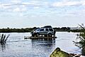
Crossing Limpopo in Mozambique


See also
 In Spanish: Limpopo para niños
- Limpopo border gates
- Great Limpopo Transfrontier Park
- List of international border rivers
- Drainage basin A
