
Gila Bend, Arizona facts for kids
Quick facts for kids
Gila Bend, Arizona
|
|||
|---|---|---|---|

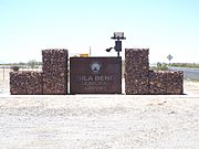
A humorous, numerically outdated sign welcomes people to Gila Bend.
|
|||
|
|||

Location in Maricopa County, Arizona
|
|||

Gila Bend, Arizona
Location in Arizona

Gila Bend, Arizona
Location in the United States
|
|||
| Country | United States | ||
| State | Arizona | ||
| County | Maricopa | ||
| Founded | 1872 | ||
| Incorporated | 1962 | ||
| Area | |||
| • Total | 64.37 sq mi (166.71 km2) | ||
| • Land | 64.37 sq mi (166.71 km2) | ||
| • Water | 0.00 sq mi (0.00 km2) | ||
| Elevation | 696 ft (212 m) | ||
| Population
(2020)
|
|||
| • Total | 1,892 | ||
| • Density | 29.39/sq mi (11.35/km2) | ||
| Time zone | UTC-7 (MST (no DST)) | ||
| ZIP code |
85337
|
||
| Area code(s) | 928 | ||
| FIPS code | 04-27050 | ||
| GNIS feature ID | 2412681 | ||


Gila Bend (pronounced HEE-luh Bend) is a town in Maricopa County, Arizona, United States. It was founded in 1872. The town gets its name from a big, almost 90-degree bend in the Gila River nearby. In 2020, about 1,892 people lived there.
Right outside Gila Bend is the San Lucy district of the Tohono O'odham Nation. This area includes a small settlement called San Lucy, which is right next to the town.
Contents
History of Gila Bend
Early Settlements and Visitors
The town of Gila Bend is close to an ancient village built by the Hohokam people. In 1699, Father Eusebio Francisco Kino was the first European to visit this area. He was exploring the Colorado River. The Hohokam village along the Gila River had been left empty, but other tribes lived nearby.
About 132 Pima people lived in a village called Oyadaibuc near where Gila Bend is today. Father Kino named it San Felipe y Santiago del Oyadaibuc. Other Pima people lived in villages upriver, mixed with the Cocomaricopa or Opa tribes. During his visits, Kino counted 960 Opas living in their own villages downriver from Oyadaibuc. The Opa and Pima tribes used the river's floodwaters to water their crops.
Oyadaibuc was also visited by Juan Bautista de Anza and Father Francisco Tomas Garces in 1774. Even in the 1820s, Maricopa people lived in Gila Bend. Later, due to pressure from other tribes and illnesses, the Maricopa left Gila Bend. They joined the Pima people in the Middle Gila region. By the time of the California Gold Rush, all Maricopa villages were east of the Sierra Estrella mountains.
Travel Routes and Early Stations
During the Mexican–American War, explorers like Kearny (1846) and Cooke (1847) traveled through this area. They didn't find any villages. In 1849, a path that became the Southern Emigrant Trail passed through. By 1854, this area was known as Tezotal or Tesotal. This name came from the desert ironwood tree (Olneya tesota), which was mentioned in a plant report.
From 1857, a place at 33°00′01.87″N 112°41′55.83″W / 33.0005194°N 112.6988417°W was called "Gila Ranch." It was a stop for stagecoaches to get water and camp on the San Antonio-San Diego Mail Line. In 1858, it became "Gila Ranch Station" on the famous Butterfield Overland Mail route to California. This station was 17 miles (27 km) east of Murderer's Grave Station. It was also 40 miles (64 km) west of Maricopa Wells Station, across a dry area called the Forty Mile Desert.
In 1859, Desert Station was built with its own well, about halfway across the Forty Mile Desert. Two water tanks were also set up to water horses. The Gila Ranch station was burned down in 1860 but quickly rebuilt. The Butterfield line closed in 1861. However, during the American Civil War, Gila Ranch remained a stop for travelers and soldiers.
The Town of Gila Bend Grows
After the Civil War, new stagecoach routes started in Arizona Territory in 1866. Gila Ranch Station became a busy stage stop again. A settlement called Gila Bend grew around it starting in 1865. It got its own post office on May 1, 1871.
Many travel and shipping routes met here, especially after the railroad arrived in 1879. In 1880, the railroad drilled wells near their Gila Bend station, which was away from the river. People started moving to a new town about 4 miles (6.4 km) south-southwest of the old one, closer to the station. The postmaster from the old station was one of the first to move and became the postmaster of the new town.
Gila Bend is sometimes called the "Crossroads of the Southwest." This is because it was an important meeting point for transportation routes. These routes helped in the settlement and growth of the American Southwest. Gila Bend was like the "center of a wheel," with many paths leading out from it.
Recent Developments
In October 1995, there was an event where the Amtrak Sunset Limited train was damaged near Gila Bend.
On December 14, 2006, Volkswagen of America, Inc., rented a large area of land (11,900 acres or 48 km²) west of Gila Bend. They plan to build a new testing ground for cars there.
Gila Bend is also known for its fun roadside attractions. Besides its unique welcome sign, the town has several outdoor sculptures. There's also the Space Age Lodge motel and restaurant, which opened in 1963. It's famous for its "Space Age" design and decorations.
In 2010, a company called Abengoa Solar got a big loan to build a large solar power plant in Gila Bend. This plant, called the Solana Generating Station, started providing power in 2013. It created many jobs during its construction and still employs about 85 people.
Geography and Climate
Where is Gila Bend?
Gila Bend is in the southwestern part of Maricopa County. It's located just off Interstate 8 on Arizona State Route 85. This route connects I-8 to Interstate 10 north of Gila Bend. The town's website calls Gila Bend "The Crossroads of the Southwest" because of its important location on old travel routes.
Gila Bend is about 68 miles (109 km) southwest of Phoenix. It's 122 miles (196 km) northwest of Tucson and 116 miles (187 km) east of Yuma. The town covers an area of about 64.4 square miles (167 km²), all of which is land. At 735 feet (224 m) above sea level, Gila Bend has the lowest elevation of any city in Maricopa County.
Weather in Gila Bend
Gila Bend has a very dry desert climate. This means it has extremely hot summers and warm winters. On average, it only rains about 7 inches (177.8 mm) per year.
In the winter months, daytime temperatures are usually between 65°F and 75°F (18°C to 24°C). Like other desert areas, the heat quickly disappears after the sun sets. Temperatures can drop more than 30 degrees in one evening. Winter nights usually have lows around 40°F to 50°F (4°C to 10°C). The coldest temperature ever recorded in Gila Bend was 10°F (−12°C) on January 13, 1963.
Summers in Gila Bend are extremely hot. Temperatures often reach or go above 110°F (41°C) throughout the summer and into early September. Even in May, some days can be over 100°F (38°C). The average high in July is 109°F (43°C), and temperatures over 115°F (46°C) are common. Summer nights are generally warm, in the upper 70s and low 80s. The hottest temperature ever recorded in Gila Bend was 122°F (50°C). This happened on June 26, 1990, and again on July 28, 1995.
| Climate data for Gila Bend, Arizona, 1991–2020 normals, extremes 1892–present | |||||||||||||
|---|---|---|---|---|---|---|---|---|---|---|---|---|---|
| Month | Jan | Feb | Mar | Apr | May | Jun | Jul | Aug | Sep | Oct | Nov | Dec | Year |
| Record high °F (°C) | 90 (32) |
95 (35) |
101 (38) |
110 (43) |
121 (49) |
122 (50) |
122 (50) |
120 (49) |
120 (49) |
114 (46) |
99 (37) |
90 (32) |
122 (50) |
| Mean maximum °F (°C) | 79.5 (26.4) |
83.5 (28.6) |
92.3 (33.5) |
101.0 (38.3) |
107.8 (42.1) |
113.6 (45.3) |
116.1 (46.7) |
114.8 (46.0) |
111.1 (43.9) |
103.6 (39.8) |
90.3 (32.4) |
78.8 (26.0) |
116.8 (47.1) |
| Mean daily maximum °F (°C) | 71.1 (21.7) |
74.8 (23.8) |
81.8 (27.7) |
89.5 (31.9) |
97.8 (36.6) |
107.3 (41.8) |
109.2 (42.9) |
108.6 (42.6) |
103.7 (39.8) |
92.9 (33.8) |
79.7 (26.5) |
69.5 (20.8) |
90.5 (32.5) |
| Daily mean °F (°C) | 56.2 (13.4) |
59.6 (15.3) |
65.6 (18.7) |
72.1 (22.3) |
80.3 (26.8) |
89.5 (31.9) |
95.0 (35.0) |
94.6 (34.8) |
88.7 (31.5) |
76.5 (24.7) |
63.8 (17.7) |
54.8 (12.7) |
74.7 (23.7) |
| Mean daily minimum °F (°C) | 41.3 (5.2) |
44.3 (6.8) |
49.3 (9.6) |
54.7 (12.6) |
62.7 (17.1) |
71.7 (22.1) |
80.7 (27.1) |
80.6 (27.0) |
73.6 (23.1) |
60.1 (15.6) |
47.9 (8.8) |
40.0 (4.4) |
58.9 (15.0) |
| Mean minimum °F (°C) | 29.0 (−1.7) |
34.0 (1.1) |
38.2 (3.4) |
44.2 (6.8) |
52.2 (11.2) |
62.0 (16.7) |
70.3 (21.3) |
70.8 (21.6) |
61.5 (16.4) |
45.5 (7.5) |
34.8 (1.6) |
27.8 (−2.3) |
25.5 (−3.6) |
| Record low °F (°C) | 10 (−12) |
23 (−5) |
25 (−4) |
28 (−2) |
39 (4) |
42 (6) |
47 (8) |
54 (12) |
37 (3) |
31 (−1) |
22 (−6) |
15 (−9) |
10 (−12) |
| Average precipitation inches (mm) | 0.76 (19) |
0.93 (24) |
0.67 (17) |
0.26 (6.6) |
0.35 (8.9) |
0.13 (3.3) |
0.59 (15) |
0.94 (24) |
0.30 (7.6) |
0.37 (9.4) |
0.46 (12) |
0.58 (15) |
6.34 (161.8) |
| Average precipitation days (≥ 0.01 in) | 2.4 | 3.1 | 2.5 | 0.9 | 0.5 | 0.1 | 2.5 | 3.9 | 1.5 | 1.2 | 1.3 | 2.6 | 22.5 |
| Source 1: NOAA | |||||||||||||
| Source 2: National Weather Service | |||||||||||||
Population of Gila Bend
| Historical population | |||
|---|---|---|---|
| Census | Pop. | %± | |
| 1910 | 199 | — | |
| 1920 | 745 | 274.4% | |
| 1930 | 1,275 | 71.1% | |
| 1960 | 1,813 | — | |
| 1970 | 1,795 | −1.0% | |
| 1980 | 1,585 | −11.7% | |
| 1990 | 1,747 | 10.2% | |
| 2000 | 1,980 | 13.3% | |
| 2010 | 1,922 | −2.9% | |
| 2020 | 1,892 | −1.6% | |
| 2022 (est.) | 1,876 | −2.4% | |
| U.S. Decennial Census | |||
In 2000, there were 1,980 people living in Gila Bend. These people lived in 659 households, and 492 of those were families. The town had about 86.7 people per square mile (33.5 per km²).
About 42.8% of households had children under 18. More than half (52.7%) were married couples. About 14.3% of households had a female head with no husband. The average household had 3 people, and the average family had 3.51 people.
The population was quite young. About 32.9% were under 18, and 11.6% were between 18 and 24. The median age was 29 years old. This means half the people were younger than 29, and half were older.
The average income for a household in Gila Bend was $26,895. For families, it was $30,403. About 24.8% of the people lived below the poverty line. This included 29.3% of those under 18.
Historic Places to See
Gila Bend has several old buildings and sites that are important to its history. Here are some of them:
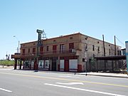
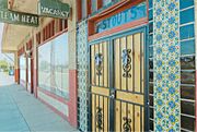
- The Stout Hotel was built in 1927. It's located at 113 East Pima Street. People called it "The Jewel of the Desert." The hotel closed in the 1980s. It is listed as a historical building and was added to the National Register of Historic Places in 2018.
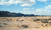
- Gatlin Site is an important historical location. Its exact address is kept private. It was added to the National Register of Historic Places in 1966.
- Gila Bend Overpass was built between 1933 and 1934. It's on Business Route 8, going over the Southern Pacific railroad tracks. It was listed in the National Register of Historic Places in 1966.
- The Gila Bend Steam Locomotive Water Stop was built in 1900. It's located near Murphy Street. This stop provided water for steam trains.
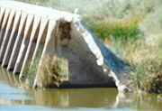
- Gillespie Dam Highway Bridge is northwest of Gila Bend. This bridge was built in 1927 over the Gila River. It was once the longest highway bridge in Arizona. It was added to the National Register of Historic Places in 1981.
- Gillespie Dam – You can see the ruins of the Gillespie Dam from Gila Bend.
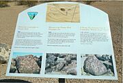
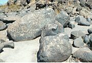
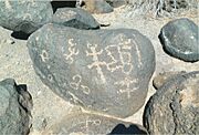
- Painted Rock Petroglyph Site is along Rocky Point Road, northwest of Gila Bend. This site has ancient rock carvings. It was listed in the National Register of Historic Places in 1977.
- The Fortaleza is another historic site whose address is restricted. It was added to the National Register of Historic Places in 1969.
Images for kids
Here are some pictures of the historic buildings and sites in Gila Bend and the areas around it.

-
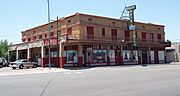
The Stout Hotel
-
Different view of the Stout Hotel
-
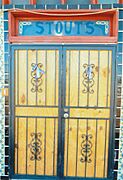
Stout Hotel main door
-
Front view of the Stout Hotel
-
Gatlin site
-
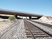
The Gila Bend Overpass
-
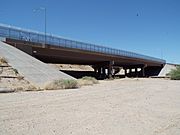
Different view of the Gila Bend Overpass
-
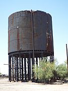
The Gila Bend Steam Locomotive Water Stop was built in 1900 and is located near Murphy Street.
-
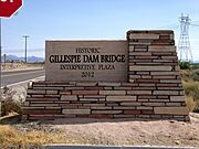
The historic Gillespie Dam Bridge marker
-
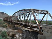
The historic Gillespie Dam Bridge
-
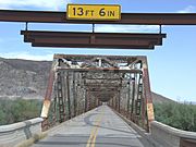
Front view of the historic Gillespie Dam Bridge
-
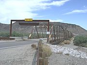
Different view of the historic Gillespie Dam Bridge
-
Ruins of the Gillespie Dam
-
Painted Rock Petroglyph Site
-
Painted Rock Petroglyph Site
-
Painted Rock Petroglyph Site
-
Entrance of the Gila Bend Municipal Airport
-
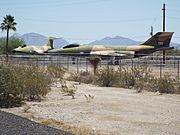
Retired Arizona National Guard Aircraft in the main entrance of the Gila Bend Municipal Airport


See also
 In Spanish: Gila Bend (Arizona) para niños
