
Gillespie Dam facts for kids
Quick facts for kids Gillespie Dam |
|
|---|---|

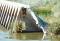
The Gila River flows freely through the breached dam.
|
|
| Official name | Gillespie Dam |
| Location | Maricopa County, Arizona, US |
| Coordinates | 33°13′45″N 112°46′10″W / 33.22917°N 112.76944°W |
| Purpose | Irrigation |
| Status | Decommissioned |
| Opening date | 1921 |
| Demolition date | 1993 |
| Dam and spillways | |
| Type of dam | Gravity dam |
| Impounds | Gila River |
| Height | 80 feet (24 m) |
| Length | 1,700 feet (520 m) |
| Reservoir | |
| Creates | Gillespie Dam Reservoir (former) |
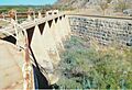
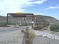
The Gillespie Dam was a large concrete structure built on the Gila River. It was located in Arizona, between the towns of Buckeye and Gila Bend, Arizona.
The dam was built in the 1920s mainly to help with irrigation. This means it helped bring water to farms. It was very important for watering a huge area of land, about 72,000 acres. This land belonged to a wealthy person named W.S. Gillespie. The dam first helped water 10,000 acres of farmland. Sadly, part of the dam broke in 1993 because of very heavy rains.
Contents
Building the Gillespie Dam
The Gillespie Dam was built around 1920. A local rancher named Frank Gillespie started the project. His company, the Gillespie Land and Irrigation Company, built it to replace an older structure.
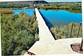
The dam was placed at an important spot where people often crossed the river. This crossing later became part of a major road, U.S. Route 80. The Arizona Highway Department built a concrete area at the bottom of the dam. This allowed cars to drive across the river.
Because the dam was a simple overflow type, water would sometimes flow over the road. During heavy rains, cars had to be pulled across by trucks. When floods happened, no one could cross the river at all.
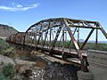
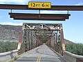
The Gillespie Dam Bridge
In 1926, the U.S. Highway System was being planned. The Highway Department decided to build a new bridge near the dam. This bridge, called the Gillespie Dam Bridge, was a steel truss bridge. It was built just a little bit downstream from the dam.
The bridge was finished and opened on August 1, 1927. It cost about US$320,000, which was a lot of money back then. At the time, it was the longest highway bridge in Arizona. It quickly became part of U.S. Route 80.
The bridge carried traffic for US 80 until 1956. After that, the highway was no longer used as a main route. The bridge then became a county road and was cared for by Maricopa County. Because of its history, the bridge was added to the National Register of Historic Places on May 5, 1981.
A Town That Never Was
The dam was also supposed to support a new town. This town, also named Gillespie, was planned to be built about 12 miles west of Gila Bend. It would have been located along the Southern Pacific Railroad.
W.S. Gillespie reportedly planned to spend $1,000,000 to build this town. His plans included paved streets, sidewalks, shops, a hotel, and many homes. It was also supposed to have modern water and lighting systems. However, the town was never fully built.
Why the Dam Broke
The winter of 1993 had a lot of rain. This caused record amounts of water to flow through rivers in central Arizona. The Salt River, which flows into the Gila River upstream from the dam, had especially high water levels.
On January 9, 1993, at about 10:30 in the morning, the dam broke. A section about 120 feet long collapsed into the river. We don't know the exact reason why it broke, but the extreme flooding was definitely a big part of it.
The flood was so big that the equipment used to measure it broke. But based on a high-water mark, experts guessed the water flow was about 200,000 cubic feet per second. This kind of flood is expected only once every 65 years. The biggest flood before this was in 1980, with 178,000 cubic feet per second.
When the dam broke, three underground natural gas pipes were exposed. The floodwaters later broke these pipes. Luckily, the Gillespie Dam Bridge downstream survived the flood and was still safe to use.
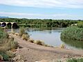
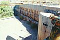
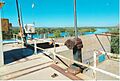
Today, parts of the dam are still there. The area is open to the public. A small dirt wall now helps send water into nearby canals.
Images for kids
-
Ruins of the dam
-
The ruins of the dam
-
Different view of the dam
-
The Gillespie Dam
-
Rusted equipment on the dam
-
More rusted equipment on the dam
-
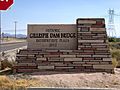
The historic Gillespie Dam Bridge marker
-
The historic Gillespie Dam Bridge
-
Front view of the bridge
-
Different view of the bridge


