Buckeye, Arizona facts for kids
Quick facts for kids
Buckeye, Arizona
|
||
|---|---|---|
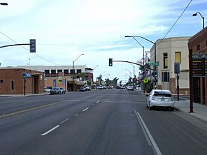
Historic downtown Buckeye as seen from Monroe Avenue in October 2015
|
||
|
||
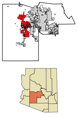
Location in Maricopa County, Arizona
|
||
| Country | United States | |
| State | Arizona | |
| County | Maricopa | |
| Government | ||
| • Type | Council-Manager | |
| Area | ||
| • Total | 393.2 sq mi (1,018.29 km2) | |
| • Land | 393 sq mi (1,017.83 km2) | |
| • Water | 0.18 sq mi (0.45 km2) | |
| Elevation | 1,076 ft (328 m) | |
| Population
(2020)
|
||
| • Total | 91,502 | |
| • Density | 232.84/sq mi (89.90/km2) | |
| Time zone | UTC−7 (MST (no DST)) | |
| ZIP codes |
85326, 85396
|
|
| Area code(s) | 623, 602, 480, 928 | |
| FIPS code | 04-07940 | |
| GNIS feature ID | 2411736 | |
Buckeye is a city in Maricopa County, Arizona, United States. It is the second-largest city in Arizona by land area. Buckeye is also the westernmost suburb of the Phoenix Metropolitan Area.
In 2020, about 91,502 people lived there. This was a big jump from 50,876 people in 2010. Buckeye was the fastest-growing city in the United States in 2017, 2018, and 2021.
Contents
History of Buckeye
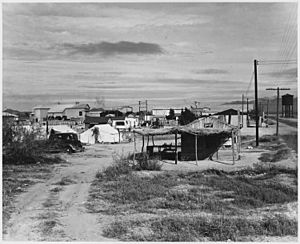
The Buckeye area was first home to the Hohokam people. In 1877, a group of families led by Thomas Newt Clanton moved from Iowa to this area. They were among the first settlers.
An early settler named Malie M. Jackson built the Buckeye Canal. This canal was 10 miles (16 km) long and was built between 1884 and 1886. He named it after his home state of Ohio, which is known as "The Buckeye State."
The town was founded in 1888. It was first called "Sidney" after Jackson's hometown. But because the canal was so important, people started calling the town Buckeye. The name was officially changed to Buckeye in 1910.
Buckeye became an official town in 1929. At that time, it covered about 440 acres (1.8 km²). The town's first mayor was Hugh M. Watson, who served from 1956 to 1958. He also started the Buckeye Valley Bank. Today, Watson Road is a main shopping area in the city.
In 2014, Buckeye officially became a city. In May 2019, it was named the fastest-growing city in the U.S. by percentage. It grew by 8.5% from 2017 to 2018.
Geography and Nature
Buckeye is about 30 miles (48 km) west of downtown Phoenix. It is located in the Buckeye Valley. Interstate 10 runs through the middle of the city.
The city is very large, covering about 393.2 square miles (1,018.4 km²). A small part of this area is water. The Gila River flows through the Buckeye Valley. To the south are the Buckeye Hills and Little Rainbow Valley. The city limits also include parts of the White Tank Mountains to the north. The Hassayampa River also flows through the northern part of Buckeye.
The soil in Buckeye is usually alkaline. It is mostly well-drained loam or clay loam. In some northern areas, the soil is more sandy or gravelly.
Buckeye's Neighborhoods
The original part of Buckeye was built around Monroe Avenue, its main street. Today, there are almost 30 large, planned communities in Buckeye. Some of these communities where people live include Riata West, Sundance, Verrado, Sienna Hills, Westpark, Tartesso, and Festival Ranch.
There are also many planned communities that are not yet built. These include Douglas Ranch, which is planned to have almost 300,000 people. Sundance Towne Center is a shopping area that opened in 2007.
Buckeye's Climate
Buckeye has a hot desert climate. This means it gets a lot of sunshine. Summers are extremely hot. Temperatures often reach over 100°F (38°C). The highest temperature ever recorded was 128°F (53°C) on July 28, 1995. Even in cooler summer periods, it can feel sticky due to higher humidity from the monsoon. However, actual rain from the monsoon is rare.
Winters, from November to March, are warm during the day. Temperatures are usually around 68°F (20°C) or warmer. It can get cold at night, with temperatures sometimes dropping below 32°F (0°C). The coldest temperature ever recorded was 11°F (-12°C) on January 8, 1913. Snowfall is very rare in Buckeye.
| Climate data for Buckeye, Arizona (1971–2000); extremes 1893–2001 | |||||||||||||
|---|---|---|---|---|---|---|---|---|---|---|---|---|---|
| Month | Jan | Feb | Mar | Apr | May | Jun | Jul | Aug | Sep | Oct | Nov | Dec | Year |
| Record high °F (°C) | 100 (38) |
92 (33) |
101 (38) |
106 (41) |
115 (46) |
122 (50) |
125 (52) |
120 (49) |
119 (48) |
108 (42) |
96 (36) |
87 (31) |
125 (52) |
| Mean daily maximum °F (°C) | 68.3 (20.2) |
73.2 (22.9) |
78.7 (25.9) |
87.3 (30.7) |
95.9 (35.5) |
105.8 (41.0) |
108.4 (42.4) |
106.3 (41.3) |
101.0 (38.3) |
90.0 (32.2) |
76.8 (24.9) |
68.2 (20.1) |
88.3 (31.3) |
| Mean daily minimum °F (°C) | 36.7 (2.6) |
40.4 (4.7) |
44.6 (7.0) |
49.6 (9.8) |
57.5 (14.2) |
65.3 (18.5) |
74.2 (23.4) |
73.6 (23.1) |
66.1 (18.9) |
53.1 (11.7) |
41.3 (5.2) |
35.8 (2.1) |
53.2 (11.8) |
| Record low °F (°C) | 11 (−12) |
18 (−8) |
20 (−7) |
29 (−2) |
32 (0) |
42 (6) |
49 (9) |
48 (9) |
41 (5) |
26 (−3) |
20 (−7) |
12 (−11) |
11 (−12) |
| Average rainfall inches (mm) | 0.80 (20) |
0.80 (20) |
0.99 (25) |
0.26 (6.6) |
0.15 (3.8) |
0.07 (1.8) |
0.67 (17) |
1.22 (31) |
0.75 (19) |
0.64 (16) |
0.64 (16) |
0.92 (23) |
7.91 (199.2) |
| Average rainy days (≥ 0.01 inch) | 3.4 | 3.1 | 4.0 | 1.5 | 0.8 | 0.4 | 2.0 | 4.1 | 2.4 | 2.3 | 1.9 | 3.1 | 29 |
| Source: National Oceanic and Atmospheric Administration | |||||||||||||
People of Buckeye
| Historical population | |||
|---|---|---|---|
| Census | Pop. | %± | |
| 1910 | 684 | — | |
| 1920 | 726 | 6.1% | |
| 1930 | 1,077 | 48.3% | |
| 1940 | 1,305 | 21.2% | |
| 1950 | 1,932 | 48.0% | |
| 1960 | 2,286 | 18.3% | |
| 1970 | 2,599 | 13.7% | |
| 1980 | 3,434 | 32.1% | |
| 1990 | 5,038 | 46.7% | |
| 2000 | 6,537 | 29.8% | |
| 2010 | 50,876 | 678.3% | |
| 2020 | 91,502 | 79.9% | |
| 2022 (est.) | 105,567 | 107.5% | |
| U.S. Decennial Census | |||
| Race / Ethnicity (NH = Non-Hispanic) | Pop 2000 | Pop 2010 | Pop 2020 | % 2000 | % 2010 | % 2020 |
|---|---|---|---|---|---|---|
| White alone (NH) | 3,748 | 25,375 | 43,071 | 57.34% | 49.88% | 47.07% |
| Black or African American alone (NH) | 215 | 3,412 | 6,187 | 3.29% | 6.71% | 6.76% |
| Native American or Alaska Native alone (NH) | 86 | 602 | 947 | 1.32% | 1.18% | 1.03% |
| Asian alone (NH) | 24 | 849 | 1,435 | 0.37% | 1.67% | 1.57% |
| Pacific Islander alone (NH) | 0 | 79 | 234 | 0.00% | 0.16% | 0.26% |
| Some Other Race alone (NH) | 4 | 100 | 484 | 0.06% | 0.20% | 0.53% |
| Mixed Race or Multi-Racial (NH) | 64 | 970 | 3,507 | 0.98% | 1.91% | 3.83% |
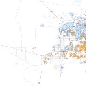
| Hispanic or Latino (any race) | 2,396 | 19,489 | 35,637 | 36.65% | 38.31% | 38.95% |
| Total | 6,537 | 50,876 | 91,502 | 100.00% | 100.00% | 100.00% |
Buckeye first appeared in the U.S. Census in 1910. It became an official city on January 1, 2014.
In 2010, there were 50,876 people living in Buckeye. About 10.8% of the people were born outside the United States.
The population includes many young people. About 30.6% of the people were under 18 years old. Most people, 53%, were between 18 and 64 years old. About 6.7% were 65 years or older. Almost half of the population, 45.4%, were women.
In 2016, the average household income in Buckeye was about $58,711. The average income per person was about $20,446.
Economy and Jobs
Buckeye has many different employers. Here are some of the top places where people work in the city:
| # | Employer | # of Employees |
|---|---|---|
| 1 | State of Arizona | 1,220 |
| 2 | Walmart | 1,120 |
| 3 | Buckeye Union High School District | 500 |
| 4 | City of Buckeye | 480 |
| 5 | Litchfield Elementary School District | 470 |
| 6 | Buckeye Elementary School District | 320 |
| 7 | Clayton Homes Inc. | 300 |
| 8 | Liberty Elementary School District | 230 |
| 9 | Agua Fria Union High School District | 160 |
| 10 | Youngker High School | 150 |
Parks and Fun Things to Do
A popular place for outdoor activities in Buckeye is the Buckeye Hills Regional Park. It is about 7 miles (11 km) south of downtown Buckeye. There are plans to build a large Buckeye Lake, which will be about 900 acres (3.6 km²) in size.
Skyline Regional Park is another great place. It is a huge mountain preserve, about 8,700 acres (35 km²) in size. It is located in the southern White Tank Mountains. As of August 2020, the park has almost 20 miles (32 km) of trails. These trails are perfect for hiking, mountain biking, and horseback riding. The park also has picnic areas and places for camping. Entry to Skyline Regional Park is free.
Schools and Learning
Buckeye is served by several school districts. These districts help educate students from kindergarten through high school.
Some of the school districts include:
- Wickenburg Unified School District
- Saddle Mountain Unified School District #90
- Agua Fria Union High School District
- Buckeye Union High School District
- Arlington Elementary School District
- Buckeye Elementary School District
- Liberty Elementary School District
- Litchfield Elementary School District
- Morristown Elementary School District
- Palo Verde Elementary School District
There are also other schools like The Odyssey Preparatory Academy.
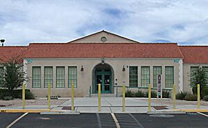
Estrella Mountain Community College has a satellite campus in Buckeye. It is located in the old Buckeye Union High School building. This building is also known as the "A" Wing. Classes started there in the fall of 2011. This center offers college courses, job training, and community classes.
Transportation
Buckeye has good transportation options. It is served by several highways, a local airport, and train lines.
Roads
Major roads that go through Buckeye include:
Buses
Buckeye has bus service provided by Valley Metro. There is a bus line that connects Phoenix, Goodyear, Gila Bend, and Ajo. Valley Metro also offers express bus service for people who commute to downtown Phoenix.
Trains
The railroad first came to Buckeye in 1910. This was a very important event for the town. A steam train line connected Buckeye to Phoenix by 1912. The business district even moved to be closer to the train station. The arrival of the railroad helped Buckeye grow quickly.
Today, Union Pacific operates a train line that runs east to west through the city.
Air Travel
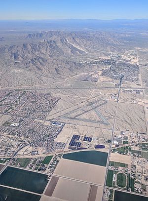
The Buckeye Municipal Airport is owned and operated by the city government. Its code is KBXK.
Famous People from Buckeye
- Kole Calhoun, a professional baseball player for the Cleveland Guardians.
- Upton Sinclair, a famous author.
See also
 In Spanish: Buckeye (Arizona) para niños
 | Emma Amos |
 | Edward Mitchell Bannister |
 | Larry D. Alexander |
 | Ernie Barnes |


