Gillespie Dam Bridge facts for kids
Quick facts for kids Gillespie Dam Bridge |
|
|---|---|
 |
|
| Coordinates | 33°13′38″N 112°46′10″W / 33.227261°N 112.769413°W |
| Carries | Old US 80 Highway |
| Crosses | Gila River |
| Locale | Maricopa County, Arizona, United States |
| Named for | Gillespie Dam |
| Owner | Maricopa County, Arizona |
| Maintained by | Maricopa County Department of Transportation (MCDOT) |
| Inventory No. | 08021 |
| Characteristics | |
| Design | Through truss bridge |
| Material | Steel |
| Pier construction | Concrete |
| Total length | 1,662 ft (507 m) |
| Width | 25 ft (8 m) |
| Longest span | 336 ft (102 m) |
| Number of spans | 9 |
| Piers in water | 8 |
| History | |
| Designer | Ralph Hoffman |
| Constructed by | Lee Moor Construction Company |
| Construction begin | January 1926 |
| Construction end | August 1927 |
| Construction cost | $320,000 |
| Opened | August 21, 1927 |
| Rebuilt | 2011-2012 |
| Replaces | Gillespie Dam auto apron Antelope Hill Highway Bridge |
|
Gillespie Dam Bridge
|
|
| Nearest city | Arlington, Arizona |
| Area | 0.72 acres (0.29 ha) |
| Built | 1927 |
| Built by | Lee Moor Construction Company, Arizona Highway Department |
| MPS | Vehicular Bridges in Arizona MPS |
| NRHP reference No. | 81000136 |
| Added to NRHP | May 5, 1981 |
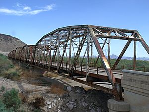
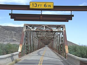
The Gillespie Dam Bridge is a special kind of bridge called a through truss bridge. It crosses the Gila River in Maricopa County, Arizona. This bridge was built to help cars get around the Gillespie Dam. Before the bridge, cars had to drive through the river on a concrete path, which often closed when the river flooded.
Building the bridge started in 1925 and finished in 1927. For many years, until 1956, it was part of U.S. Route 80. This was a very long highway that went all the way across the United States, from San Diego, California, to Tybee Island, Georgia. In 2012, the bridge was fixed up and now has a special area for visitors to learn about its history. It became part of the Historic US 80 route in 2018.
Contents
Bridge History: Building a Path Across the River
In 1911, people from California, Arizona, and New Mexico met in Phoenix. They decided to create a new road called the Ocean-to-Ocean Highway. Their goal was to build a road that could be used in all kinds of weather, connecting the country.
A part of this highway, about 200 miles (320 km) long, went from Yuma to Phoenix. It crossed the Gila River and passed through towns like Arlington and Buckeye.
Early Bridge Attempts and Challenges
In 1912, Lamar Cobb, a state highway engineer, started planning a bridge over the Gila River. He looked at different spots, and finally chose a place near Antelope Hill. Construction on the first bridge, called the Antelope Hill Highway Bridge, began in 1914. It was made of wood and concrete and was about 1,000 feet (300 m) long.
Building this bridge was not easy. The first builder quit, and a flood in the winter of 1914 damaged the unfinished bridge. The state then used unpaid prisoners to finish the work, and the bridge was ready in 1915.
However, the road and the Antelope Hill Bridge faced many problems. The highway was built on weak soil in a floodplain, which is an area that floods easily. Floods in 1919 and 1920 badly damaged the road. The Antelope Hill Bridge itself was often washed out by heavy floods. Its wooden parts had to be replaced, and concrete sections needed constant repairs. Even though it was strong for cars, it couldn't handle the powerful flash floods of the desert.
A New Plan: The Gillespie Dam and a Temporary Fix
Because of all the flooding problems, the Arizona Highway Department decided in 1920 to change the highway's path. The new route would go south of the river through Gila Bend. But since Arlington was on the north side of the river, a new way to cross the Gila was needed.
An interesting solution came from Frank A. Gillespie, a businessman. In 1921, his company built the Gillespie Dam across the Gila River for irrigation. The Highway Department first thought about building a bridge over the dam. But instead, they built a temporary concrete path at the bottom of the dam. This "apron" allowed cars to drive through the river. It opened in 1922.
However, this temporary path had its own issues. When the river was high or dangerous, the path would close. Sometimes, several cars even had to be tied together to cross safely!
Designing the Gillespie Dam Bridge
Three years after the concrete apron was built, the Arizona Highway Department started planning a proper bridge again. In April 1925, they began studying the riverbed. They asked bridge engineer R.V. Leeson for advice.
Because Arizona had so many problems with concrete bridges, Leeson suggested building a steel through truss bridge. This type of bridge uses strong steel frames. Highway Department engineer Ralph Hoffman worked with Leeson to design a "Camelback through truss bridge." This design is also known as a Parker truss.
The bridge's foundations would go deep into the solid rock below the riverbed. Each steel section would be 200 feet (61 m) long and very heavy. The road itself would be made of strong steel and concrete. It was designed to hold two 15-ton trucks at the same time. This new bridge would also be a Federal Aid Project, meaning the government would help pay for it.
Building the Bridge: Challenges and Completion
In January 1926, the Highway Department looked for companies to build the bridge. The Lee Moor Construction Company from El Paso, Texas won the job because they offered the lowest price. Workers immediately started building the piers, which are the supports for the bridge.
Digging the foundations for the piers was tough. Groundwater often filled the holes. Large pumps had to work for five weeks to remove thousands of gallons of water every minute until the piers were finished. On November 11, 1926, the Ocean-to-Ocean Highway became part of the new U.S. Route 80. This was a new system of numbered federal highways that stretched across the country.
In February 1927, a huge flood hit the Gila River. It was so bad that the US 80 dam apron closed for six days. The flood also washed away a lot of equipment and materials needed for the bridge. This delayed construction by two months.
The Lee Moor team returned in the spring of 1927. They finished putting up the steel truss sections. Then, they poured the concrete for the road, painted the steel, and installed guard rails. The new Gillespie Dam Bridge officially opened on August 1, 1927. Cars could finally cross the Gila River without worrying about floods. The whole project cost $320,000.
The Bridge's Legacy and Restoration
When it was finished, the Gillespie Dam Bridge was one of the longest highway structures in Arizona. It was also the longest steel bridge at the time. The bridge was added to the National Register of Historic Places on May 5, 1981, recognizing its importance.
Even though US 80 was updated over the years, the Gillespie Dam Bridge remained a main part of the highway until 1956. That's when a new road was built to the east. Today, this newer road is part of Arizona State Route 85. The US 80 name was removed from Maricopa County in 1977.
In 1993, a powerful flood on the Gila River destroyed the Gillespie Dam. The rush of water also caused some minor damage to the bridge's support piers. But because of its strong steel design and deep foundations, the bridge did not collapse. Its design is a big reason why it has lasted so long.
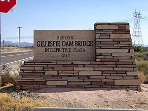
From 2011 to 2012, the Gillespie Dam Bridge underwent a $7.3 million restoration by Maricopa County. This project made the concrete piers and steel sections even stronger. They also replaced parts and built the Gillespie Dam Interpretive Plaza, a place for visitors to learn. The Gillespie Dam Bridge is one of only two multiple-span steel through truss bridges still standing in Arizona. On September 21, 2018, the Gillespie Dam Bridge and Old US 80 Highway were officially named part of Historic U.S. Route 80.
 | John T. Biggers |
 | Thomas Blackshear |
 | Mark Bradford |
 | Beverly Buchanan |


