Tajique, New Mexico facts for kids
Quick facts for kids
Tajique, New Mexico
|
|
|---|---|

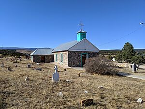
San Antonio Catholic Church
|
|

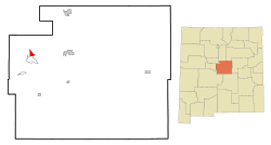
Location of Tajique, New Mexico
|
|
| Country | United States |
| State | New Mexico |
| County | Torrance |
| Area | |
| • Total | 2.70 sq mi (7.00 km2) |
| • Land | 2.70 sq mi (7.00 km2) |
| • Water | 0.00 sq mi (0.00 km2) |
| Elevation | 6,844 ft (2,086 m) |
| Population
(2020)
|
|
| • Total | 106 |
| • Density | 39.20/sq mi (15.14/km2) |
| Time zone | UTC-7 (Mountain (MST)) |
| • Summer (DST) | UTC-6 (MDT) |
| ZIP code |
87016
|
| Area code(s) | 505 |
| FIPS code | 35-76060 |
| GNIS feature ID | 2410052 |
Tajique is a small, unincorporated community located in Torrance County, New Mexico, in the United States. It is a special area that the United States Census Bureau defines as a census-designated place (CDP) for counting people. Tajique is also part of the larger Albuquerque metropolitan area. In 2020, about 106 people lived there.
Contents
Discovering Tajique's Location
Tajique is located in the state of New Mexico. It covers a total area of about 2.7 square miles (7.0 square kilometers). All of this area is land, with no water.
A Look into Tajique's Past
Early Pueblo Life and Missions
Tajique was originally a village of the Tiwa Puebloans, who are Native American people. The name "Tajique" might have come from the Tiwa language. We don't know exactly when the first people settled here.
In the early 1600s, Tajique was home to the San Miguel Mission. This was a religious center. In 1674, a group called the Apache raided the area. Because of this, people from the nearby Quarai village joined the Tajique pueblo. This made the population grow to over 600 people. However, another Apache raid in 1675 forced everyone to leave the Tajique pueblo.
Facing Wildfires in Tajique
In recent times, Tajique has faced challenges from wildfires. In April 2008, the Trigo Fire came close to the area. This fire burned about 13,709 acres (55.48 square kilometers) and destroyed 59 homes.
Later that same year, in June 2008, the community of Tajique had to be evacuated because of the Big Spring Fire. This fire burned 5,478 acres (22.17 square kilometers). It sadly destroyed six homes and 10 other buildings in Tajique.
Understanding Tajique's Population
| Historical population | |||
|---|---|---|---|
| Census | Pop. | %± | |
| 2020 | 106 | — | |
| U.S. Decennial Census | |||
In the year 2000, there were 148 people living in Tajique. These people lived in 48 households, and 39 of these were families. The population density was about 54.7 people per square mile (21.1 people per square kilometer).
Most households had families living together. About 41.7% of households had children under 18 years old. About 56.3% were married couples. The average household had about 3 people, and the average family had about 3.28 people.
The population of Tajique in 2000 included people of different ages. About 35.8% were under 18 years old. About 10.1% were 65 years or older. The average age of people in Tajique was 31 years.
See also
 In Spanish: Tajique (Nuevo México) para niños
 | Mary Eliza Mahoney |
 | Susie King Taylor |
 | Ida Gray |
 | Eliza Ann Grier |


