
Duran, New Mexico facts for kids
Quick facts for kids
Duran, New Mexico
|
|
|---|---|
|
Census-designated place
|
|

Duran, New Mexico
Location in New Mexico
|
|
| Country | United States |
| State | New Mexico |
| County | Torrance |
| Area | |
| • Total | 4.69 sq mi (12.15 km2) |
| • Land | 4.69 sq mi (12.15 km2) |
| • Water | 0.00 sq mi (0.00 km2) |
| Elevation | 6,221 ft (1,896 m) |
| Population
(2020)
|
|
| • Total | 44 |
| • Density | 9.38/sq mi (3.62/km2) |
| Time zone | UTC-7 (Mountain (MST)) |
| • Summer (DST) | UTC-6 (MDT) |
| Area code(s) | 575 |
| GNIS feature ID | 2584090 |
Duran is a small community in Torrance County, New Mexico, United States. It's a special kind of place called a census-designated place. This means it's a community that the government counts for population, but it's not officially a city or town. Duran is found where two important roads meet: U.S. Route 54 and New Mexico State Road 3. It's about 14 miles (23 km) southwest of a town called Vaughn. In 2010, only 35 people lived here. By 2020, the population grew slightly to 44 people.
History of Duran
-
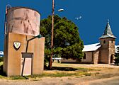
Water tower and church

Duran was first established in 1902. This happened when a railroad line was built and extended to this location. The railroad was very important back then for connecting places and moving goods. A post office also opened in Duran in 1902. This helped people send and receive mail, which was a big deal before emails and phones!
Education in Duran
Students living in Duran attend schools run by the Vaughn Municipal Schools district. This district provides education for the local area.
Population of Duran
| Historical population | |||
|---|---|---|---|
| Census | Pop. | %± | |
| 2020 | 44 | — | |
| U.S. Decennial Census | |||
The number of people living in Duran has been counted by the United States Census. In 2010, there were 35 residents. By the time of the 2020 census, the population had increased to 44 people.
See also
 In Spanish: Duran (Nuevo México) para niños
